Features of the Polish climate
what weather and climate are;
what the weather components are;
what instruments are used to measure each weather component;
how to read information on climatic charts;
what factors affect the Polish climate;
how do climate‑forming factors affect the weather components and the climate components in Poland.
name the features of Poland's transitional climate;
analyse climate maps;
what the climatic seasons of the year are;
how the foehn wind and the sea breeze are formed;
what effect air masses have on the vegetative season.
Description of climate in a specific location requires describing its main components. The most important components of any climate are average air temperature and total precipitation volume. Of lesser importance are winds, cloudiness, atmospheric pressure, air humidity, occurrence of storms, mists or other weather phenomena. How to characterise the Polish climate, taking all these factors into account?
Average air temperatures in Poland
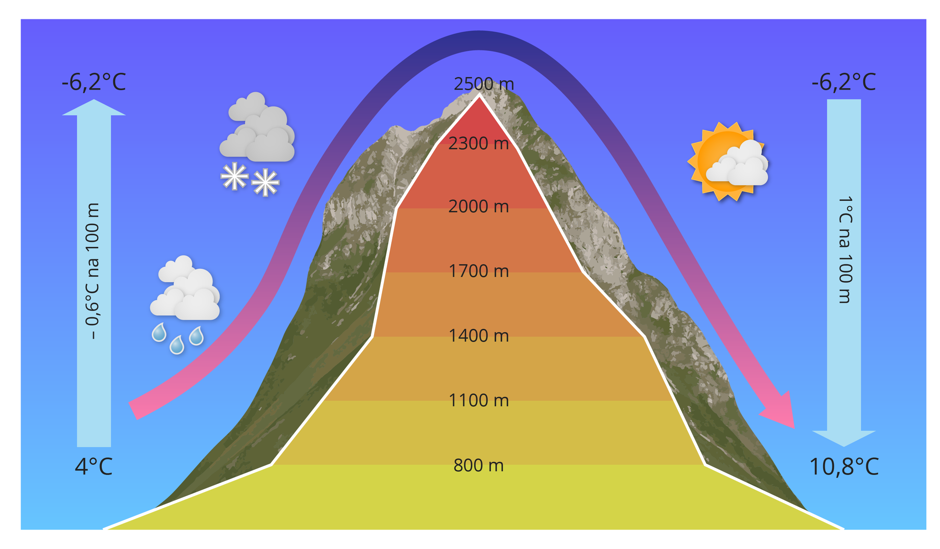
Average air temperatures are primarily affected by latitude – it affects falling angle of sun rays reaching the Earth’s surface, and therefore general amount of heat. Distance from the sea or the ocean is also very important. Humid marine air accumulates heat slower in comparison to dry inland air. Their temperature is also affected by the surface. Water heats up slower than land, and also loses heat slower. Therefore, at the sea, it is cooler in summer and warmer in winter, in comparison to inland area. Another factor affecting air temperature is absolute altitude. Temperature drops, on average, by 0.6° per 100 m – this is the reason it is usually colder in the mountains than in the lowlands.
On a map, air temperatures are presented by isothermsisotherms. They are lines connecting points with identical temperature values. Additionally, for better comprehension, area between isotherms are filled with colours – “warmer” or “colder”.
Draw on the outline map of Poland the isotherm system in winter.
Match the seasons with their specific daily average temperatures (°C)
5-15, 5-0, Below 0, 0-5, Above 15, 15-5
| Winter | |
| Early spring | |
| Spring | |
| Summer | |
| Autumn | |
| Early winter |
The following infographic contains information about the vegetative season of plants in Poland.
Total annual precipitation
Humid masses of marine polar air from above the Atlantic Ocean, oncoming from the west, bear essential influence on the amount and intensity of precipitation. They bring significant amounts of steam which condenses or freezes and falls to Earth in the form of rain or snow. In area of Poland, one can notice a dependency of amount of precipitation on local land morphology. The largest volumes of precipitation are recorded over higher terrains – in the mountains, on highlands and the lakelands. Over such areas, air motion may be prevented by hills, being natural obstacles. The lowest volumes, however, occur on flat lands in central Poland, particularly in Kuyavia and Greater Poland. These regions lie in so‑called “precipitation shadow” of the lakelands.
Both the map and the climatic charts display clearly increased precipitation over mountain areas. High terrain obstacles, such as the mountains, not only prevent humid air masses from the movement, but also favour emergence of convection currents. Within this currents, air which heated up at the ground level rises high and suddenly cools down which leads to condensation of steam.
Looking at climatic charts, one also needs to pay attention to annual precipitation distribution in Poland. It is more or less the same all over the country, i.e. summer precipitation is prevalent.
Winds in Poland
Air temperature difference triggers pressure difference which, in turn, causes air motion – wind.
Apart from winds originating from major barycentres, local winds appear in Poland as well. One of them is , locally called “halny”. It is formed as a result of pressure difference between two sides of a mountain ridge. Mostly, it occurs in the high mountains – the Tatra Mountains or Karkonosze. From the side where the pressure is higher, the air climbs on the slopes (lifts). Next, this air mass rises up and cools down, forming dense cumulus clouds out of condensed steam. Rain falls down, drying up air. Such dry air flows over the mountain chain to the other side where it “slips down” and warms up. Usually, the pressure difference is high which means that warm and dry halny may reach huge speed (often > 100 km/h) and therefore is able to inflict serious damage.
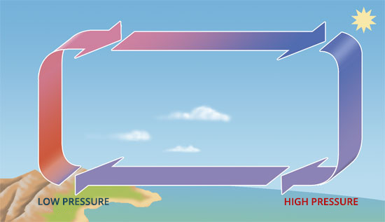
Another local wind is breezebreeze, occurring at the sea. Breezes are formed as a result of the difference of air pressure between land area and water area. Humid air over water changes its temperature more slowly than dry air over land. Therefore, during daylight hours it is warmer over land, and warmed up air rises up, leaving lower pressure below which attracts air from above water. This is a sea breeze (onshore breeze). At night, conditions reverse – it is warmer over water because air above this area cools down more slowly; lower air pressure is formed, attracting air from above land. This is a land breeze (offshore breeze).
What kind of wind is specific for the area visible in the picture?
- Land breeze (offshore breeze)
- Sea breeze (onshore breeze)
- Halny
- Bora
Choose the correct type of wind occurring in a specific region of Poland.
- Sea breeze (onshore breeze)
- Land breeze (offshore breeze)
- Foehn
- Sirocco
Fill in gaps in the text, using given options.
lower, higher, pressure, hurricane, west, horizontal
Wind is a .................... movement of atmospheric air. It is caused by .................... difference. Wind always blows from the area with .................... pressure to the area with .................... pressure. In Poland, most winds are .................... winds. An example of an extreme weather phenomenon is a .................... which may cause extensive devastation within its area of activity.
Try and remember how the following lines are named.
| Contour lines on a map, connecting points with the same temperature values. | ISOTHERMS |
| Contour lines on a map, connecting points with the same precipitation values. | ISOHYETS |
| Contour lines on a map, connecting points with the same atmospheric pressure values. | ISOBARS |
Keywords
isotherms, wind, climate
Glossary
amplituda temperatury – różnica między najwyższą a najniższą temperaturą w danym miejscu; najczęściej oblicza się amplitudy dobowe i roczne
bryza – wiatr nadmorski powstający w wyniku różnicy ciśnień między powietrzem nad lądem a powietrzem nad wodą; bryza morska wieje w dzień od morza w stronę lądu, a bryza lądowa wieje w nocy od lądu w stronę morza
fen – silny wiatr górski powstający w wyniku różnicy ciśnienia atmosferycznego pomiędzy dwiema stronami grzbietu górskiego; w Polsce nazywany jest wiatrem halnym
inwersja temperatury – odwrócenie zasady, że im wyżej, tym zimniej; występuje czasami w dolinach i kotlinach górskich, gdzie osiada zimne powietrze, które jest cięższe od powietrza ciepłego
izoterma – linia na mapie łącząca punkty o takiej samej wartości temperatury