Rocks, present in crust, are usually arranged in layers. The rule of thumb is that older rocks lie at higher depths, and younger rocks lie at lower depths. Of course, some deviations might happen, for example, in folds, faults, shifts or other deformations of rock layers. On maps, profiles, diagrams and other drawings, older rocks are usually marked with darker colours, and younger ones are marked with brighter colours.
Task 1
There are various rocks in vicinity of your place of residence. Using the available resources find out which rocks are typical for this area. Assign them to appropriate categories.
There are various rocks in vicinity of your place of residence. Using the available resources find out which rocks are typical for this area. Assign them to appropriate categories.
There are various rocks in vicinity of your place of residence. Using the map below find out which rocks are typical for this area. Assign them to appropriate categories. Make an appropriate note in your notebook.
R1JG9JVU0x8dN
Mapa przedstawiająca rodzaje i wiek skał Polski oraz podział na ery. 1. Poland. Types of rocks and their age , 2. Precambrian, Paleozoic, Mesozoic, Cainozoic
Mapa przedstawiająca rodzaje i wiek skał Polski oraz podział na ery. 1. Poland. Types of rocks and their age , 2. Precambrian, Paleozoic, Mesozoic, Cainozoic
Poland. Types of rocks and their age
Source: Wydawnictwo Edukacyjne Wiking, licencja: CC BY 3.0.
Knowledge of geological structure enables human to perform various activities in everyday life, such as:
drawing water from underground sources;
extraction of mineral resources;
correct erection of buildings.
Knowledge of geological structure geological structuregeological structuregeological structure may also help find interconnections occurring in natural environment: rock – soil – water – vegetation – animals. The area of the Central Poland Plains and the Lakelands, covered in many places with Quaternary post‑glacial sands, may be an example. These layers triggered formation of rather infertile podzol soils, overgrown mainly by coniferous forests, what, in turn, led to development of specific vegetation and specific fauna.
Geological structure of Poland is a consequence of our geographical location in Central Europe, in a junction of large geological units of the continent:
the zone of young Alpine folding;
the zone of old Paleozoic foldings (Caledonides, Variscides);
the Precambrian platform.
Widespread East European Platform of Precambrian origin, overlaps with the North‑East part of the territory of Poland. The edge of this platform, called the Tornquist Zone (T‑T zone), spans from Koszalin to Tomaszów Lubelski. Old Precambrian igneous rocks and metamorphic rocks in this area are covered with horizontal layers of sedimentary rocks from later periods. The zone of Paleozoic foldings contains Sudetes with the fore‑Sudetic block, the Holy Cross Mountains, and the Upper Silesian basin. The area, stretching from these mountains to the East European Platform is so‑called Paleozoic West Europe Platform which includes old folded formations covered with younger sediments, slightly folded in late Mesozoic EraeraEra. These include the following:
the Central Poland bank;
the shoreline basin and the Szczecin‑Miechów basin;
the fore‑Sudetic Monocline.
Currently, these unites are covered with Caenozoic formations. The zone of Alpine folding in our country includes Carpathians and pre‑Carpathian cavity, located northward.
Rzmt69DrlALQK
Mapa przedstawiająca strefy tektoniczne Polski. Wyróżnić można: powierzchnię fałdów kenozoicznych, Area of Cenozoic folds, platformę paleozoiczną, Paleozoic platform, powierzchnię późnych fałd paleozoicznych, rea of Late Paleozoic folds, powierzchnię wczesnych fałd paleozoicznych, Area of Early Paleozoic folds. Północno-wschodnia część Polski to Platforma Prekambryjska. Centralna i zachodnia część Polski tworzy niecki i wyniesienia. Południowo- zachodnia część tworzy monokliny oraz kompleksy skalne. Południowo-wschodnia część tworzy kompleksy skalne.
Mapa przedstawiająca strefy tektoniczne Polski. Wyróżnić można: powierzchnię fałdów kenozoicznych, Area of Cenozoic folds, platformę paleozoiczną, Paleozoic platform, powierzchnię późnych fałd paleozoicznych, rea of Late Paleozoic folds, powierzchnię wczesnych fałd paleozoicznych, Area of Early Paleozoic folds. Północno-wschodnia część Polski to Platforma Prekambryjska. Centralna i zachodnia część Polski tworzy niecki i wyniesienia. Południowo- zachodnia część tworzy monokliny oraz kompleksy skalne. Południowo-wschodnia część tworzy kompleksy skalne.
Poland. Main tectonic zones
Source: Wydawnictwo Edukacyjne Wiking, licencja: CC BY 3.0.
Task 2
Wyjaśnij jak powstają góry.
Wyjaśnij jak powstają góry.
Watch the film. Pay attention to how the rock material is formed and how do mountains uplift - what is the reason for their formation? Write your answers here or in a notebook.
RDicjWss53bMY
Film za pomocą prostego doświadczenia pokazuje jak powstają góry. Do doświadczenia użyto: maki pszennej, mąki kukurydzianej, łyżeczki, wody, piasku i nożyczek oraz butelki. Rozcinamy butelkę w 2/3 wysokości. Większą część rozcinamy wzdłuż. Obie części łączymy- jedna za druga. Wsypujemy piasek, dodajemy wody, mąkę kukurydzianą, ponownie dodajemy wody, mąkę pszenną, dodajemy wodę. Czekamy godzinę, symulujemy nakładanie się płyt tektonicznych poprzez wciskanie wyciętych części butelek jednej w drugą. Podczas tej czynności widać jak napierające na siebie mieszanki piasku z mąką tworzą wzniesienia.
Film za pomocą prostego doświadczenia pokazuje jak powstają góry. Do doświadczenia użyto: maki pszennej, mąki kukurydzianej, łyżeczki, wody, piasku i nożyczek oraz butelki. Rozcinamy butelkę w 2/3 wysokości. Większą część rozcinamy wzdłuż. Obie części łączymy- jedna za druga. Wsypujemy piasek, dodajemy wody, mąkę kukurydzianą, ponownie dodajemy wody, mąkę pszenną, dodajemy wodę. Czekamy godzinę, symulujemy nakładanie się płyt tektonicznych poprzez wciskanie wyciętych części butelek jednej w drugą. Podczas tej czynności widać jak napierające na siebie mieszanki piasku z mąką tworzą wzniesienia.
Film za pomocą prostego doświadczenia pokazuje jak powstają góry. Do doświadczenia użyto: maki pszennej, mąki kukurydzianej, łyżeczki, wody, piasku i nożyczek oraz butelki. Rozcinamy butelkę w 2/3 wysokości. Większą część rozcinamy wzdłuż. Obie części łączymy- jedna za druga. Wsypujemy piasek, dodajemy wody, mąkę kukurydzianą, ponownie dodajemy wody, mąkę pszenną, dodajemy wodę. Czekamy godzinę, symulujemy nakładanie się płyt tektonicznych poprzez wciskanie wyciętych części butelek jednej w drugą. Podczas tej czynności widać jak napierające na siebie mieszanki piasku z mąką tworzą wzniesienia.
R1VYLTnxQleqe
Film analysis: "How are mountains formed?". How is the rock material formed? (Uzupełnij). What is cause of the uplift of mountains? (Uzupełnij).
Film analysis: "How are mountains formed?". How is the rock material formed? (Uzupełnij). What is cause of the uplift of mountains? (Uzupełnij).
Film analysis: "How are mountains formed?"
Geological history of Poland throughout the history of the Earth
Currently, there is sea in the north of Poland, and the mountains in the south. However, it was not always like that. For millions of years, the shape of Earth’s crust and distribution of lands and oceans underwent regular changes. Climate, and thus vegetation, underwent changes as well. Depending on which era to analyse, landscapes of modern territory of Poland differed to great extent.
The most important events from the geological history of Poland, with breakdown to specific eras, are provided in the following table.
R1YNz3RPpN6ck
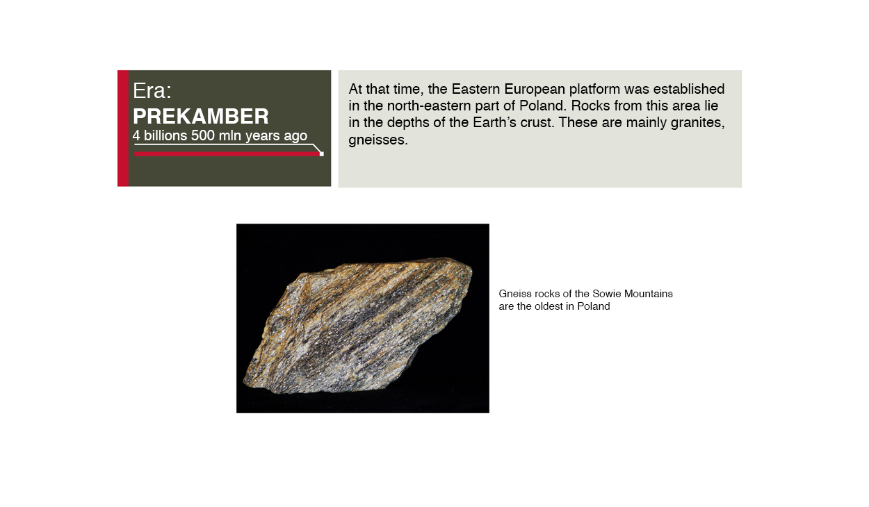
Grafika zawiera informacje: Era prekambryjska, era prekamber - cztery miliardy pięćset milionów lat temu. 4 billions 500 mln years ago. At that time, the Eastern Europe platform was established in the north-eastern part of Poland. Rocks from this area lie in the depths of the Earth’s crust. These are mainly granites, gneisses. Gneiss rocks of the Sowie Mountains are the oldest in Poland.
RSWnBlHncXx7L
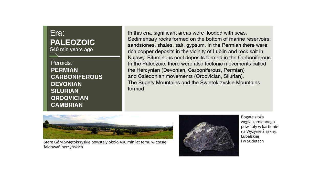
Grafika zawiera informacje: Era: Paleozoic 540 mln years ago. Periods Permian, Carboniferous, Devonian, Silurian, Ordovician, Cambrian. In this area, significant areas were floated with seas. Sedimentary rocks formed on the bottom of marine reservoirs: sandstones, shales, salt, gypsum. In the Permian there were rich copper deposits in the vicinity of Lublin and rock salt in Kujawy. Bituminous coal deposits formed in the Carboniferous. In the Paleozoic, there were also tectonic movements called the Hercynian (Devonian, Carboniferous, Permian) and Caledonian movements (Ordovician, Silurian). The Sudety Mountains and the Świętokrzyskie Mountains formed. Stare Góry Świętokrzyskie powstały około 400 mln lat temu w czasie fałdowań hercyńkskich. Bogate złoża węgla kamiennego powstały w karbonie na Wyżynie Śląskiej, Lubelskiej i w Sudetach.
Rb2A16EgayWIX
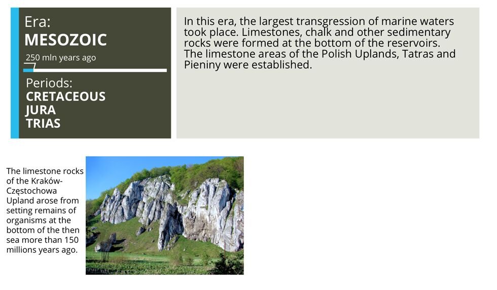
Grafika zawiera informacje: Era: mesozoic 250 mln years ago. Periods Cretaceous, Jura, Trias. In this era, the largest transgression of marine waters took place. Limestones, chalk and other sedimentary rocks were formed at the bottom of the reservoirs. The limestone areas of the Polish Uplands, Tatras and Pieniny were established. The limestone rocks of the Kraków - Częstochowa uplands arose from setting remains of organisms at the bottom of the sea more than 150 millions years ago.
R17tA7De4fznv
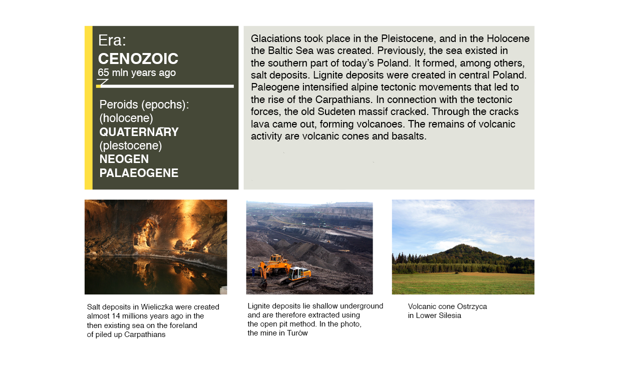
Grafika zawiera informacje: Era: Cenozoic 65 mln years ago. Periods (epochs): (holocene) Quaternary (Plestocene) Neogen Palaeogene. Glaciations took place in the Pleistocene, and in Holocene the Baltic Sea was created. Previously, the sea existed in the southern part of today’s Poland. It formed, among others, salt deposits. Lignite deposits were created in central Poland. Paleogene intensified alpine tectonic movements that led to the rise of the Carpathians. In connection with the tectonic forces, the old Sudenten massif cracked. Through the cracks lava came out, Forman volcanoes. The remains of volcanic activity are volcanic cones and basalts.
Employing knowledge gained during the lessons, do the following exercises.
Exercise 1
R2ZyIGuV9dtCp
Match the following rocks with their locations. Gneiss, Jurassic limestone, Granite.
Możliwe odpowiedzi: 1. Tatras, 2. The Pieniny, 3. The Owl Mountains
Match the following rocks with their locations. Gneiss, Jurassic limestone, Granite.
Możliwe odpowiedzi: 1. Tatras, 2. The Pieniny, 3. The Owl Mountains
Match the following rocks with their locations.
The Owl Mountains, Tatras, The Pieniny
Gneiss
Jurassic limestone
Granite
Exercise 2
R9vIn30o0bA1V
Indicate categories relevant to a specific rock. Basalt, Rocks: Limestone, Marble, Gneiss, Gravel, Granite, Sulphur, Black coal. Categories: Metamorphic rock, Igneous intrusive rock, Igneous extrusive rock, Organic sedimentary rock, Chemical sedimentary rock, Metamorphic rock, Clastic sedimentary rock, Organic sedimentary rock.
Indicate categories relevant to a specific rock. Basalt, Rocks: Limestone, Marble, Gneiss, Gravel, Granite, Sulphur, Black coal. Categories: Metamorphic rock, Igneous intrusive rock, Igneous extrusive rock, Organic sedimentary rock, Chemical sedimentary rock, Metamorphic rock, Clastic sedimentary rock, Organic sedimentary rock.
Indicate categories relevant to a specific rock.
Gneiss
Metamorphic rock
Granite
Igneous intrusive rock
Basalt
Igneous extrusive rock
Black coal
Organic sedimentary rock
Sulphur
Chemical sedimentary rock
Marble
Metamorphic rock
Gravel
Clastic sedimentary rock
Limestone
Organic sedimentary rock
R12h5Iau3apw9
Exercise 3
Jakie znasz typy skał?
Jakie znasz typy skał?
Summary
Events from the geological history were decisive factors with regard to types of rocks and their arrangement in crust.
Rocks emerged in various eras, places, and environmental conditions. Therefore, their composition and structure provide information on the date of formation. Arrangement of rock strata allows to reconstruct chronological sequence of geological events on the territory of Poland. Fossils may also prove useful for this purpose.
In general, older rocks lie at higher depths, and younger rocks lie at lower depths.
Processes occurring in geological history led to formation of, inter alia, various mineral resources, such as metallic, energy, and rock resources.
Knowledge of geological structure of Poland may prove useful in everyday life as well as in economy.
Poland lies on the border of three large geological units in Europe: the pre‑Cambrian East European Platform, the Paleozoic folded structure, the Alpine folded structure.