Glacial landforms in Poland. Young and old glacial landscapes.
that glacial periods in Poland occurred in the Pleistocene (earlier of the two epochs that constitute the Quaternary Period in the Cenozoic Era);
that glaciation through geological surface processes has contributed to shaping the contemporary landforms;
that a glacier can take the form of an ice sheet (continental glacier) or a mountain glacier;
that an ice sheet or a mountain glacier activity results in particular landforms.
to distinguish young and old glacial landscapes;
to name glacial landforms and show them on the map of Poland;
to name glacial landforms occurring in mountain areas.
The course of glaciation in Poland
Ice sheets and glaciers form under the following conditions:
prolonged low (below 0 degrees Celsius) air temperatures;
snowfall larger than its loss through melting;
landforms enabling accumulation of snow (flat or concave landscape areas).
Over thousands of years of the Pleistocene, the climate changed, as cooler periods interspersed with warmer ones. When it was relatively cooler over a long period of time, the Scandinavian Ice Sheet increased its size. The ice slid over the neighbouring areas, including Poland (see map above) in the process of so called ice sheet advanceice sheet advance. The period when a particular area has been covered by an ice sheet is called a glacial, glaciation or simply ice age. In Poland there were four glaciations: Podlaskie (corresponding temporarily to Elbe glaciation in Northern Europe and Beestonian Stage in the British Isles) (the oldest), South Polish (Elster or Anglian Stage), Middle Polish (Saalian) and North Polish (Vistulian or Weichselian) (the most recent). Between them there were warmer periods called interglacials (that is periods between glaciations), when the ice sheet retreated from our area. It is believed that currently we observe such an interglacial.
In the table below you can find detailed data on each of the glacials and interglacials. Note that each of these periods has a few names used by geographers and geologists interchangeably. All of these names relate to the locations reached by the ice sheet in its maximum advance.
DURATION | GLACIAL |
10–110 | NORTH POLISH GLACIATION |
110–130 | Eemian interglacial |
130–310 | MIDDLE POLISH GLACIATION |
310–360 | Holstein (Mazovian) interglacial |
360–620 | SOUTH POLISH GLACIATION |
620–700 | Przasnysz (Cromerian) interglacial |
700–800 | PODLASKIE GLACIATION |
Glacial landforms in Poland
Several advances of the ice sheet on the territory of Poland have transformed its landscape. Numerous landforms emerged as a result of erosion and deposition by mountain and continental glaciers (ice sheets).
Glacial erosion is:
abrasion of the glacier bed by the rock debris carried by the glacier and the water flowing underneath;
erosion of the bed caused by the sheer pressure of the moving ice (mostly in the mountains);
physical erosion (mostly by freeze‑thaw weathering) of the rocks near the glacier.
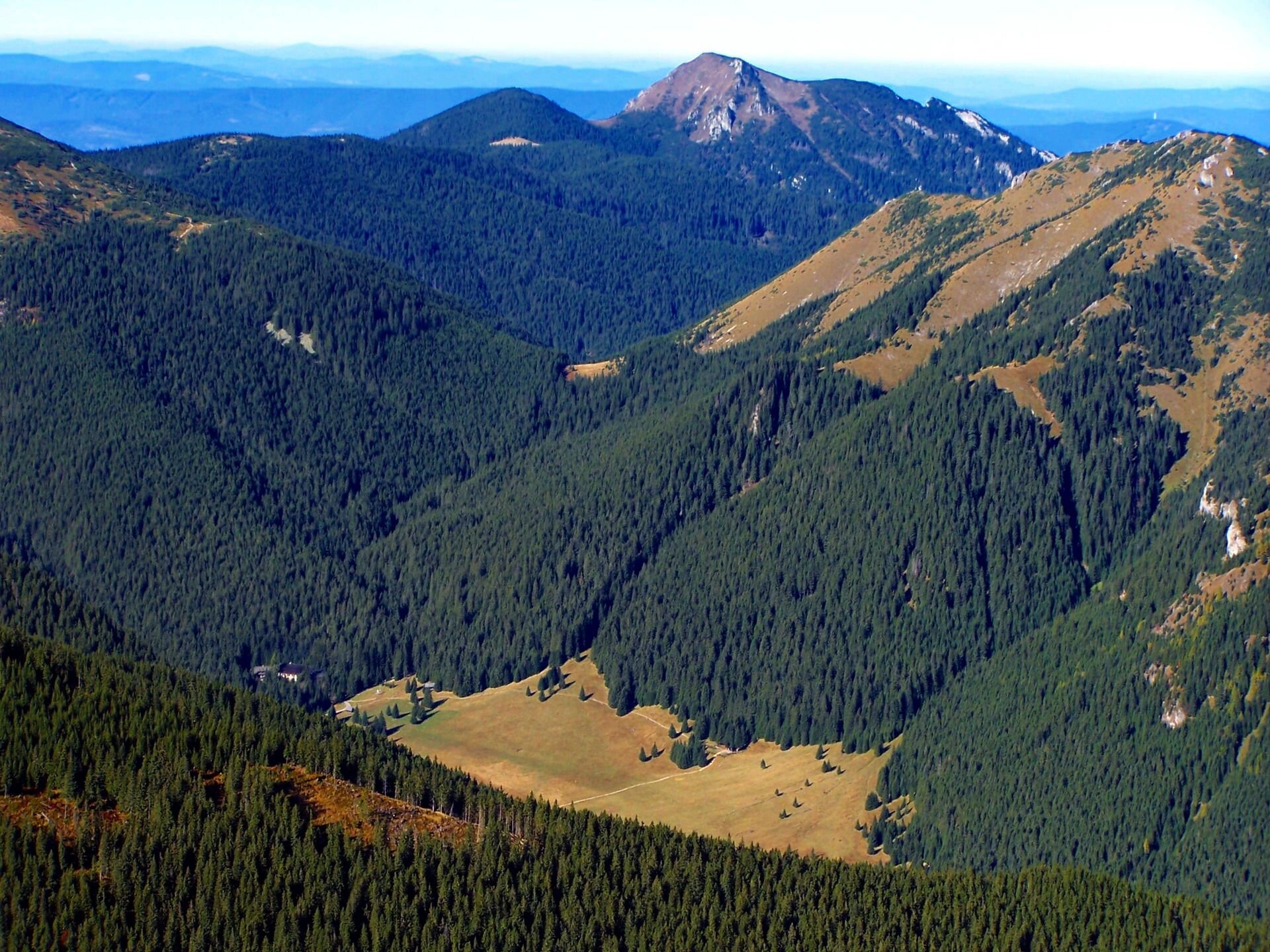
Wide U‑shaped mountain valleys – e.g. Chochołowska Valley or Kościeliska Valley in Tatra Mountains – have been carved by valley glaciers and waters flowing from them. The slopes have accumulated layers of weathered rocks, so called stone runsstone runs. On lowlands, in front of the ice sheet margin, wide meltwater valleys, so called ice‑marginal valleysice‑marginal valleys have developed, filled by large rivers. Also on lowlands, glacial meltwaters have carved deep, long and narrow hollows called tunnel valleystunnel valleys, which were later filled by water to form ribbon lakesribbon lakes.
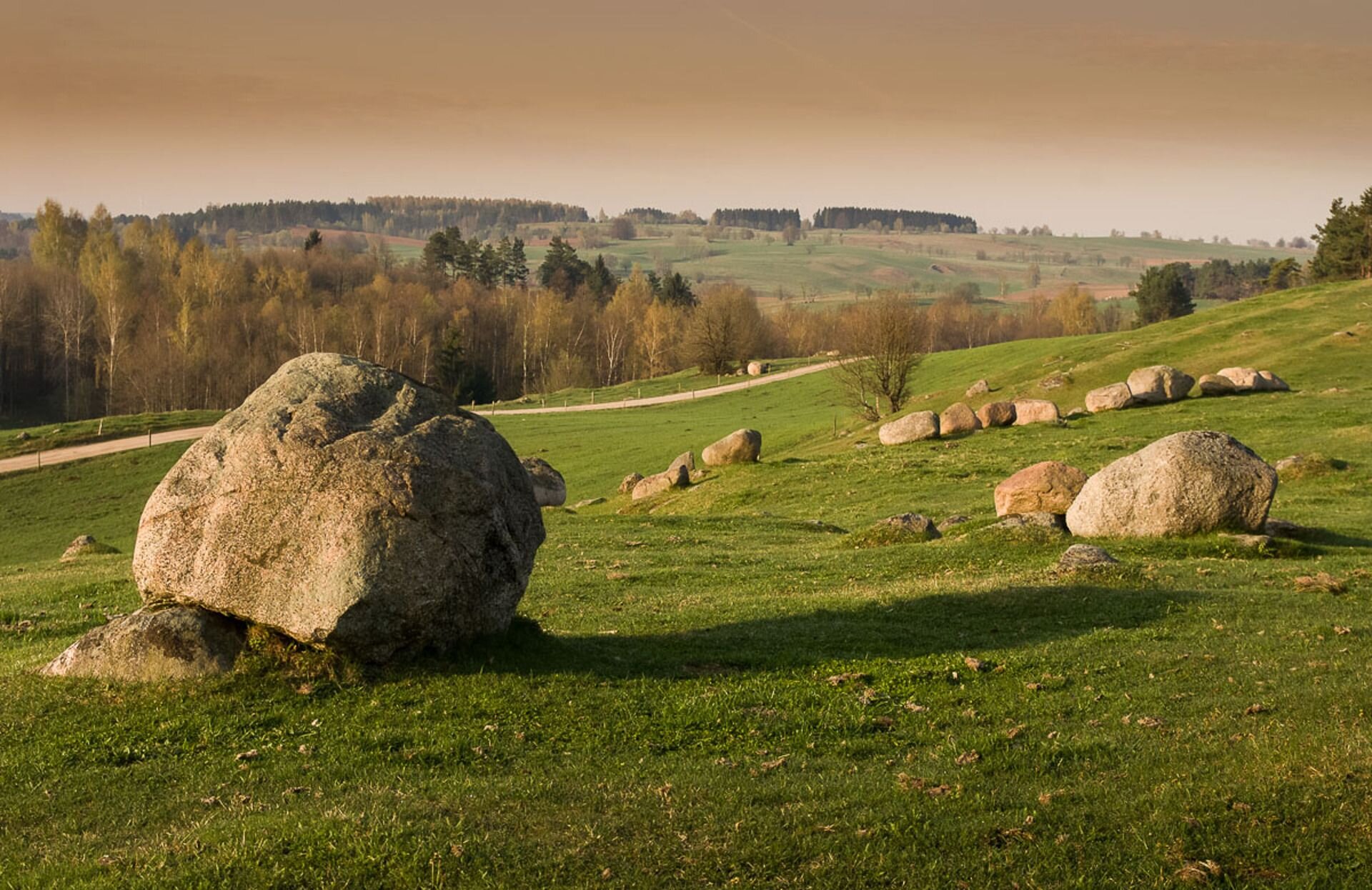
Glacial deposition is accumulation of rock debris in various places around the glacier. This process has lead to the formation of, among others, undulating landscape forms – moraines, e.g. terminalterminal, groundground, and in the mountains also laterallateral and medialmedial. On lowlands, the ice sheet has left behind erraticserratics that is scattered pieces of rocks varying in size. There have also been formed large flat sandy outwash plains also called sandurssandurs.
Young and old glacial landscapes.
Nowadays, glacial landforms can be found almost all over Poland. However, in various regions, they have remained in various condition. Glacial landforms in its best form can be found in lake districts, because these were the areas reached by the last North Polish glaciation. The landscape there is referred to as young glacial landscapeyoung glacial landscape, characterised by strongly undulating terrain and numerous glacial landforms such as: moraines, lakes sandurs, eskers, kames, drumlins etc.
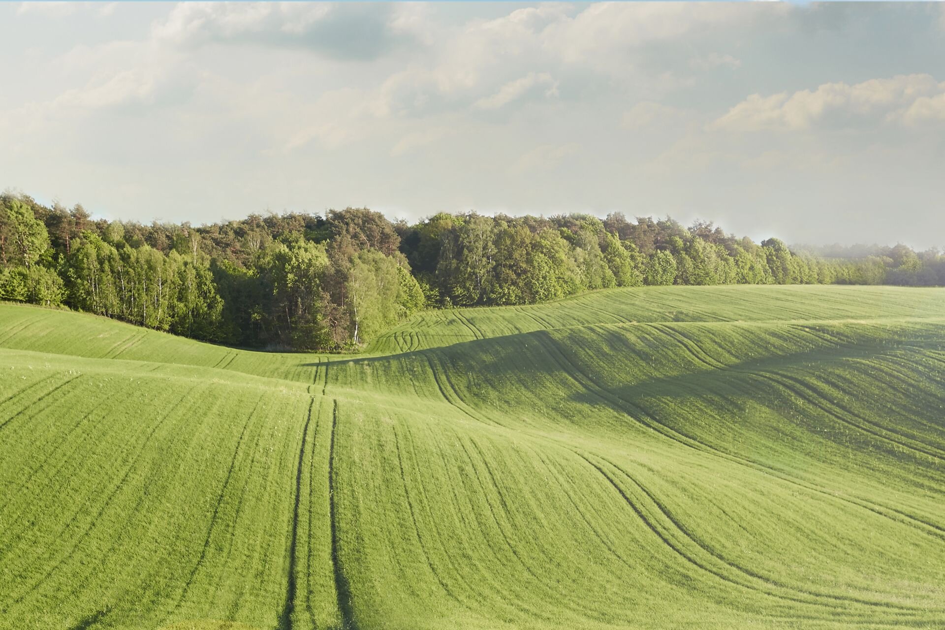
South of the lake districts, there are areas of old glacial landscapesold glacial landscapes. They include mostly the lowlands (Polish Plain) and the uplands belt. During the last glaciation, this was the area near the edge of the ice sheet that is the periglacial zoneperiglacial zone. It had a cold climate, which caused intense weathering of rocks due to freeze‑thaw and other erosive processes occurring under the conditions of permanently frozen ground (permafrost). The combination of geological processes in the periglacial environment resulted in the reworking of the earlier glacial landforms. At the same time, other forms emerged, which are characteristic for this zone: stone runs, loess sedimentsloess sediments, inland dunesinland dunes.
Match the name of the terminal moraine with the region
Masurian Lake District, Kashubian Lake District, Chełmińsko-Dobrzyńskie Lake District
| Dylewska Góra | |
| Wieżyca | |
| Szeska Góra |
Indicate two forms being a result of the accumulation activity of the glacier
- erratic blocks
- roche moutonnée, sheepback
- moraine
- ice floe
Summary
On our territory, we had four glaciations (glacials), of which the North Polish Glaciation had the strongest impact on the present landscape.
The North Polish Glaciation ended only 10 thousand years ago and shaped the young glacial landscape of the lake districts.
The young glacial landscape of our lake districts is characterised by strongly undulating terrain with numerous landforms, e.g.: lakes, ice‑marginal valleys, sandurs, terminal and ground moraines as well as other types of hills (eskers, kames, drumlins).
The old glacial landscape is found mostly on lowlands (Polish Plains), dominated by flat terrain diversified here and there by ice‑marginal valleys, morainic ridges and inland dunes.
Keywords
glaciation, ice‑marginal valleys, stone runs, old glacial landscape, young glacial landscape, glacial period, interglacial, moraine
Glossary
rzeźba młodoglacjalna – rzeźba terenu powstała w wyniku ostatniego zlodowacenia, w której dobrze zachowały się formy glacjalne, np. moreny, jeziora, sandry; w Polsce obejmuje pas pojezierzy i pobrzeży
rzeźba staroglacjalna – rzeźba terenu powstała w czasie dawnych zlodowaceń, której formy zostały już znacząco wyrównane; w Polsce obejmuje Niziny Środkowopolskie i pas wyżyn i kotlin; obszar ten znajdował się na przedpolu (w strefie peryglacjalnej) ostatniego zlodowacenia i pod wpływem zimnego klimatu powstały tam m.in. gołoborza, wydmy śródlądowe, pokrywy lessowe
strefa peryglacjalna – przedpole lodowca, gdzie panuje zimny klimat sprzyjający m.in. wietrzeniu mrozowemu i innym procesom geologicznym zachodzącym w warunkach zamarzniętego podłoża (wieloletniej zmarzliny)
transgresja lodowca – powiększanie się rozmiarów lodowca pod wpływem zimnego klimatu i pokrywanie lodem coraz to nowych terenów
kocioł polodowcowy (cyrk, kar) – zagłębienie terenu powstałe pod polami firnowymi wskutek długotrwałego działania mas lodu; miejsce, z którego wypływa jęzor lodowca górskiego; po ustąpieniu lodowca często wypełnia go woda, tworząc jezioro cyrkowe (karowe), którego przykładem jest Czarny Staw pod Rysami w Tatrach
morena czołowa – wał lub ciąg pagórków tworzący się przed czołem lodowca podczas jego dłuższego postoju, np. Wieżyca, Wzgórza Szeskie, Wzgórza Trzebnickie
morena denna – płaski lub falisty obszar urozmaicony zagłębieniami bezodpływowymi (w których po stopieniu lodu utworzyły się jeziora moreny dennej); powstaje w wyniku akumulacji materiału skalnego pod lądolodem
morena boczna – wał materiału skalnego tworzący się obok jęzora lodowca górskiego
morena środkowa – dwie połączone moreny boczne; powstaje, gdy dwa lodowce górskie znajdują się blisko siebie
głaz narzutowy (eratyk) – pojedynczy blok skalny o wielkości nawet kilku metrów występujący w różnych miejscach na obszarze polodowcowym; najczęściej był wyrwany ze skalnego podłoża przez lądolód; uwięziony w lodzie mógł zostać przetransportowany na duże odległości, np. głazy narzutowe występujące w Polsce pochodzą ze Skandynawii
sandr – duży, płaski stożek napływowy powstały na przedpolu moren czołowych; budują go głównie piaski i żwiry; naniosła je woda wypływająca z topniejącego lądolodu
pradolina – szeroka dolina o płaskim dnie, którą kiedyś płynęły wody z topniejącego lądolodu oraz rzeki; utworzyła się wzdłuż czoła lądolodu, w miejscu dłuższego jego postoju
rynna polodowcowa – długa, wąska i na ogół głęboka forma terenu o stromych zboczach i nierównym dnie; powstała wskutek działania wód podlodowcowych płynących w szczelinach lądolodu; zalana wodą tworzy jezioro rynnowe
jezioro rynnowe – powstało w wyniku wypełnienia wodą rynny polodowcowej; jest na ogół głębokie i ma wydłużony kształt, np. Gopło, Jeziorak, Wigry
jezioro wytopiskowe – utworzyło się w wyniku wytopienia brył martwego lodu, które były zagrzebane w osadach glacjalnych; ma zazwyczaj małą powierzchnię, kolisty kształt i stosunkowo dużą głębokość
jezioro moreny dennej – powstało poprzez wypełnienie wodą zagłębienia w morenie dennej; charakteryzuje się urozmaiconą linią brzegową i raczej małą głębokością, np. Śniardwy, Mamry, Wielimie
jezioro zastoiskowe – utworzyło się przed czołem lądolodu w wyniku zatamowania odpływu wód roztopowych
gołoborze – rumowisko ostrokrawędzistych głazów (bloków) skalnych powstałe w wyniku wietrzenia mrozowego; gołoborza znane są przede wszystkim z Gór Świętokrzyskich, jednak występują też w Tatrach, Karkonoszach i na Babiej Górze
osad lessowy – forma powstała w wyniku wywiewania pyłu kwarcowego przez wiatr wiejący od lądolodu; na obszarze Polski najwięcej lessu nagromadziło się na Wyżynie Lubelskiej, Wyżynie Sandomierskiej, w Niecce Nidziańskiej oraz na Nizinie Śląskiej; grubość pokładów lessu sięga miejscami nawet 30 m
wydma śródlądowa – najwięcej ich utworzyło się na piaszczystych terenach pradolin (w Puszczy Kampinoskiej i Noteckiej) oraz na rozległych sandrach; występują w postaci wydm parabolicznych oraz nieregularnych pagórków; obecnie są one przeważnie porośnięte lasami i unieruchomione