How to present absolute and relative altitude and land sculpture? What do you think?
How to present absolute and relative altitude and land sculpture? What do you think?
Source: licencja: CC 0.
Creators of historic maps did not manage presentation of land morphology and its altitude above sea level with ease. They would draw little mounds, hatched and shadowed mountains slopes which aimed to show variation of land sculpture.
Finally, invention of contour line method turned out to be a breakthrough. Contour lines (also called isohypses) are lines on a map, connecting points with identical altitude, above or below sea level. The closer two contour lines are, the steeper is the slope. The farther they are, the milder the slope.
Rt2eXjhZknnFR
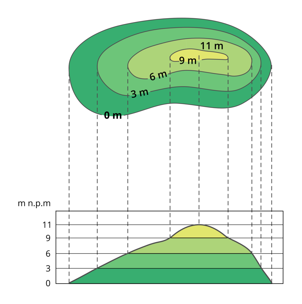
Ilustracja przedstawia metodę tworzenia profilu hipsometrycznego na podstawie mapy poziomicowej. W górnej części ilustracji mapa poziomicowa wzgórza o wysokości 11 metrów z poziomicami na zerowym metrze, trzecim, szóstym, dziewiątym i jedenastym. Od poziomic w dół poprowadzone przerywane linie prowadzące do profilu. Profil wzgórza umieszczony na wykresie. Oś pionowa to skala wyrażona w metrach nad poziomem morza. Skala kończy się na jedenastu metrach. Liniami zaznaczone kolejne poziomy wysokości wzgórza, kolejno: 3, 6, 9 i 11 metrów.
The method of creating a hypsometric profile based on a contour map.
Source: Krzysztof Jaworski, Andrzej Bogusz, licencja: CC BY 3.0.
This method evolved into the hypsometric method, consisting in combination of contour lines, showing land morphology, with appropriate colouration. In this method, spaces between contour lines are coloured according to the hypsometric colour scale, using cold and warm colours. The hypsometric method employs properties of human vision. Warm colours, e.g. yellow, orange, red, seem to be closer to the observer, and cold colours, e.g. green, blue, seem to be more distant. Therefore, convex forms, such as mountains and highlands, are marked with warm colours, and concave forms or forms lying at lower altitude, are marked with cold colours.
With application of contour line map or hypsometric map, it is possible to determine altitude differences between adjacent objects on a map with quite good accuracy. Altitude difference between two objects (e.g. between a mountain peak and a valley lying at its base) is called relative altituderelative altituderelative altitude. It is also possible to read altitude difference between a selected point and the sea level – this difference is called absolute altitudeabsolute altitudeabsolute altitude
R1YlxTT0zM9iO
Grafika przedstawiająca różnicę pomiędzy wysokością względną i wysokością bezwzględną w stosunku do poziomu morza. Po lewej stronie grafiki widoczny klif, stanowiący brzeg morza. Nad morzem widnieje podpis: Sea level. Dalej na klifie znajduje się biała flaga, a po prawej od niej, na wyższym klifie – domek. Od domku, dalej na prawo, teren zaczyna się podnosić, a następnie znów opada, tworząc wzniesienie. Nad szczytem wzniesienia poprowadzona jest pozioma, przerywana linia, która łączy się ze szczytem w jego najwyższym punkcie. Od przerywanej linii do poziomu gruntu poprowadzona jest strzałka, obok niej podpis: relative height. Od poziomu moża poprowadzona jest kolejna pozioma, przerywana linia. Między przerywanymi liniami strzałka, obok podpis: absolute height.
Way of calculating the relative and absolute altitude.
Source: tylko do użytku edukacyjnego, [online], dostępny w internecie: http://www.epodreczniki.pl.
Task 1
Wybierz jedno zagadnienie opisane w abstrakcie. Poszerz swoją wiedzę na jego temat, szukając dodatkowych informacji w dostępnych ci źródłach (np. w internecie, encyklopedii lub specjalistycznych publikacjach).
Wybierz jedno zagadnienie opisane w abstrakcie. Poszerz swoją wiedzę na jego temat, szukając dodatkowych informacji w dostępnych ci źródłach (np. w internecie, encyklopedii lub specjalistycznych publikacjach).
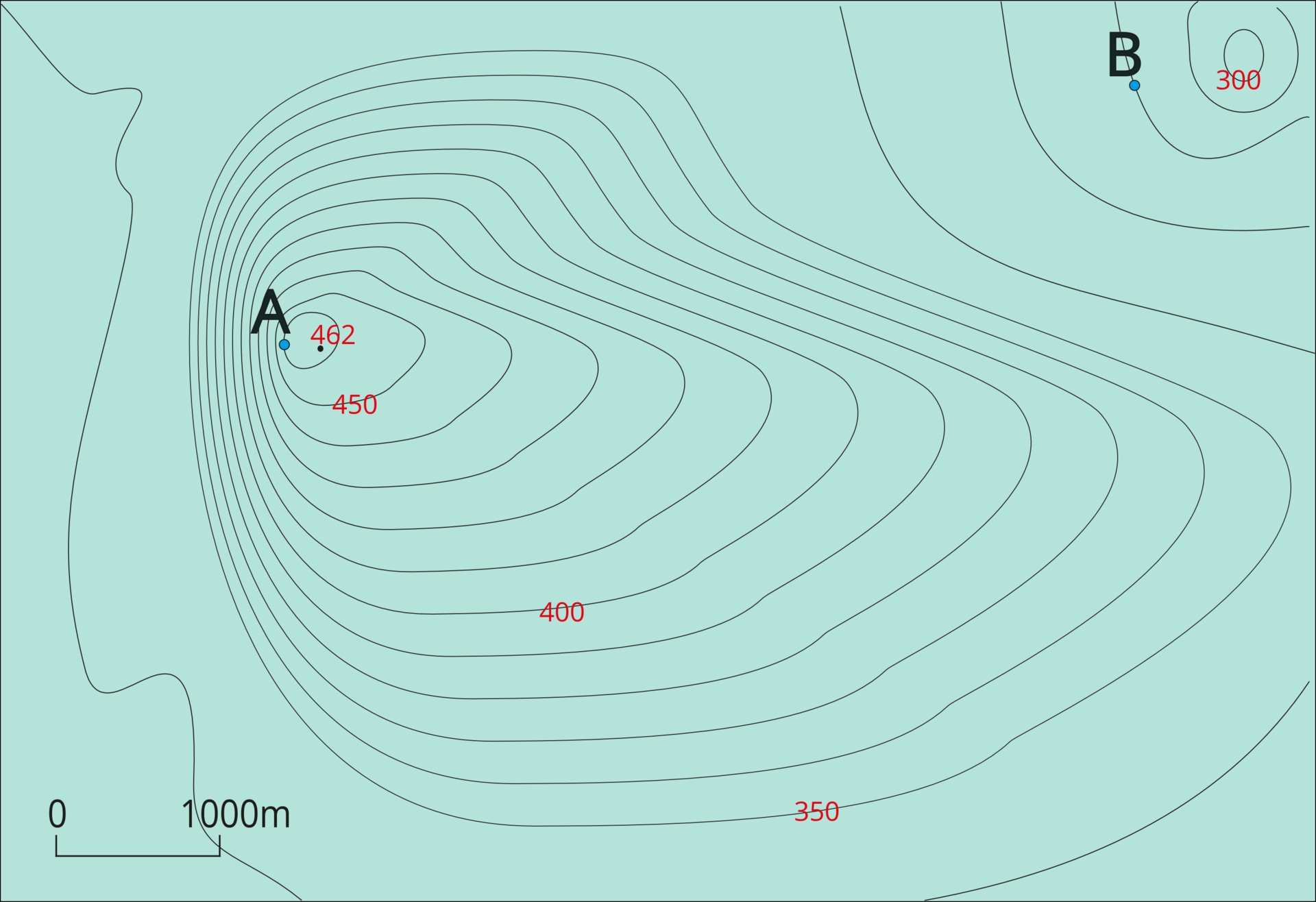
Based on attached part of a contour line map, describe sculpture of presented land.
Read absolute altitude of points A and B on attached map.
Calculate relative altitude of point A, in relation to point B.
Identify hill slopes with the highest and the lowest inclination.
R1S33Gcp4JegN
Grafika przedstawiająca mapę poziomicową wzgórza.
Map of the hill
Source: tylko do użytku edukacyjnego, [online], dostępny w internecie: http://www.epodreczniki.pl.
Task 2
Wyobraź sobie, że masz okazję przeprowadzić wywiad z naukowcem - specjalistą w dziedzinie, której dotyczy abstrakt. Sformułuj pytania, które chciałbyś mu zadać.
Wyobraź sobie, że masz okazję przeprowadzić wywiad z naukowcem - specjalistą w dziedzinie, której dotyczy abstrakt. Sformułuj pytania, które chciałbyś mu zadać.
Drawin a contour line drawing of the moutain, taking into account contour lines placed 20 m from each other. The highest point is 620 m above sea level, and the mountain base is at 380 m above sea level.
R3hU7slTwlEDa
Exercise 1
Explain the term – absolute altitude.
Explain the term – absolute altitude.
RixiF9PqeA4J9
Exercise 2
Explain the term – relative altitude.
Explain the term – relative altitude.
Task 3
Prepare three questions connected with the topic of the lesson.
Prepare three questions connected with the topic of the lesson.
Prepare a crossword, the main password is ALTITUDE. Remember that the questions and answers must be related to the topic of the class.
RaeTSr5L8Mo72
Wykonaj zadanie zgodnie z poleceniem.
Wykonaj zadanie zgodnie z poleceniem.
Make a crossword. Write down questions and answers.
Keywords
map, relative altitude, absolute altitude
RKaUZx89Xcdh5
Exercise 3
Match the pairs: English words with Polish definition. absolute altitude Możliwe odpowiedzi: 1. to różnica wysokości między wybranym obiektem a uśrednionym poziomem morzal, 2. to różnica wysokości między wybranym obiektem a punktem odniesienia innym niż poziom morza, 3. linie na mapie łączące punkty o tej samej wysokości powyżej lub poniżej poziomu morza relative altitude Możliwe odpowiedzi: 1. to różnica wysokości między wybranym obiektem a uśrednionym poziomem morzal, 2. to różnica wysokości między wybranym obiektem a punktem odniesienia innym niż poziom morza, 3. linie na mapie łączące punkty o tej samej wysokości powyżej lub poniżej poziomu morza contour lines --- isohypses Możliwe odpowiedzi: 1. to różnica wysokości między wybranym obiektem a uśrednionym poziomem morzal, 2. to różnica wysokości między wybranym obiektem a punktem odniesienia innym niż poziom morza, 3. linie na mapie łączące punkty o tej samej wysokości powyżej lub poniżej poziomu morza
Match the pairs: English words with Polish definition. absolute altitude Możliwe odpowiedzi: 1. to różnica wysokości między wybranym obiektem a uśrednionym poziomem morzal, 2. to różnica wysokości między wybranym obiektem a punktem odniesienia innym niż poziom morza, 3. linie na mapie łączące punkty o tej samej wysokości powyżej lub poniżej poziomu morza relative altitude Możliwe odpowiedzi: 1. to różnica wysokości między wybranym obiektem a uśrednionym poziomem morzal, 2. to różnica wysokości między wybranym obiektem a punktem odniesienia innym niż poziom morza, 3. linie na mapie łączące punkty o tej samej wysokości powyżej lub poniżej poziomu morza contour lines --- isohypses Możliwe odpowiedzi: 1. to różnica wysokości między wybranym obiektem a uśrednionym poziomem morzal, 2. to różnica wysokości między wybranym obiektem a punktem odniesienia innym niż poziom morza, 3. linie na mapie łączące punkty o tej samej wysokości powyżej lub poniżej poziomu morza
Match the pairs: English words with Polish definition.
linie na mapie łączące punkty o tej samej wysokości powyżej lub poniżej poziomu morza, to różnica wysokości między wybranym obiektem a punktem odniesienia innym niż poziom morza, to różnica wysokości między wybranym obiektem a uśrednionym poziomem morzal