Land-forming factors and processes. Summary
you can show tectonic plates on the map of world;
you can give the differences between a shield volcano and a volcanic cone;
you can name the types of mass movements;
you can name and point out examples of the land‑forming activity of the wind: destructive, building and accumulative;
name three types of deserts and give their examples;
show the largest deserts on the map of world;
divide and provide examples of bottom, headward and lateral erosion;
name the types of river estuaries and indicate their examples on the map;
divide and show examples of coasts using the map of world;
give differences between glaciers and ice sheets, show examples on the map of world;
explain what the perpetual snow line is;
name post‑glacial forms.
you will repeat and consolidate your knowledge and skills in the theme of: Land‑forming factors and processes.
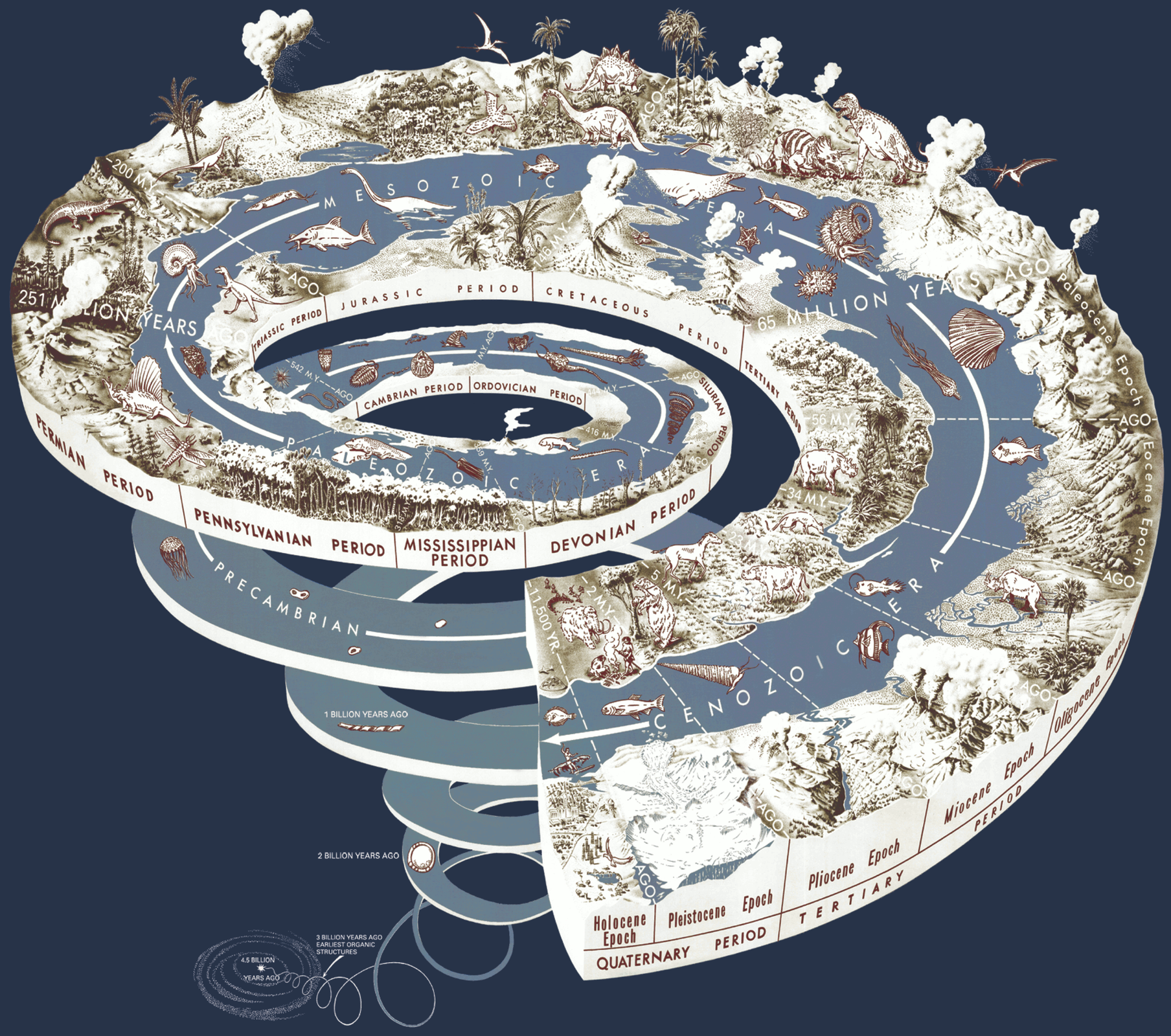
The Earth is comprised of concentric layers – the crust, the mantle and the core. Each and every layer has different physical and chemical properties. Their heterogeneity is the source of many natural phenomena, e.g. volcanic eruptions and earthquakes. Rocks are records of our planet’s long history. By examining rocks, we learn where deserts, volcanoes and seas were located in the past. Earth’s surface is constantly transforming. These changes result mainly from natural processes, which had shaped the Earth before mankind and which will continue to mould our planet even after humans cease to exist.
Earth‑forming activity of glaciers and ice sheets
On the Earth, many areas are covered with mountain glaciers and ice sheets, which are formed in appropriate climatic conditions and in places where the shape of the surface is favourable. Ice sheets cover almost the whole of Antarctica and a major part of Greenland. Glaciers form above the perpetual snow line in the mountains of all continents except Australia. As a result of the destructive and building activity of glaciers, many post‑glacial forms are created, e.g. cirque, moraines, sanders or glacial lakes.
Land‑forming activity of rivers and seas
Moving water can mechanically destroy rocks. This phenomenon is called erosion. The upper course of a river is dominated by deep erosion and headward erosion, in the middle course – lateral erosion, and meanders can form there. In the lower course, especially at the mouth of the sea or a lake, the river no longer has its erosive force, it gradually loses its ability to transport material and settles it – this is called accumulation. There are two types of river mouths: estuary and delta.
The sea or the ocean have a strong impact on a narrow strip of land called coast. Waves are constantly moving smaller fragments of rocks on the shore, increasingly crumbling them, creating a beach. This process is called abrasion. As a result of various processes, some coasts grow, others are receding. Depending on the shape of the bottom of the sea and land shores, geological processes, sea currents and some organisms, we distinguish many types of coasts. The most known are: fjord, cliff, Dalmatian, reef, lagoon or skerry.
Land‑forming activity of the wind
The wind can have destructive, transporting and building activities. For these processes to take place, the following conditions must simultaneously occur:
a strong enough wind must blow;
rocks in the ground must be finely crumbled;
the ground must not be wet;
the ground cannot be covered with abundant vegetation.
These conditions are met in the deserts almost all year round and the land‑forming activity is the strongest there. There are three main types of deserts: erg (sandy desert), serir (gravel desert), hamada (rocky desert). Blowing of fine rock material by the wind is called deflationdeflation. Blown sand can be moved even over long distances. Mounds made this way are called dunes (e.g. barchan or parabolic dunes). Sand grains carried by the wind can hit rocks, grind, groove, smoothen and scratch them – this is corrasion. Closer to the surface of the Earth, the process of corrasion is the strongest. Various, very fanciful rock forms are created, for example rocky mushrooms, yardangs or ventifacts.
Weathering of rocks
Weathering of rocks is the process of chemical or physical disintegration. Physical (mechanical), chemical (e.g. karst), and biological weathering has been distinguished. Each type of rock weathering occurs under specific climatic conditions. Karst phenomena are all processes and forms, both on the surface and underground, occurring in areas built of soluble rocks (limestones, dolomites, gypsum, chalk, salt).
Mass movements appear on most land areas. Loose rock masses and weathering products (eluvium) can move down the slope under the influence of gravity. Mass movements include: sliding, exfoliating, ripping, creeping.
Volcanism and earthquakes
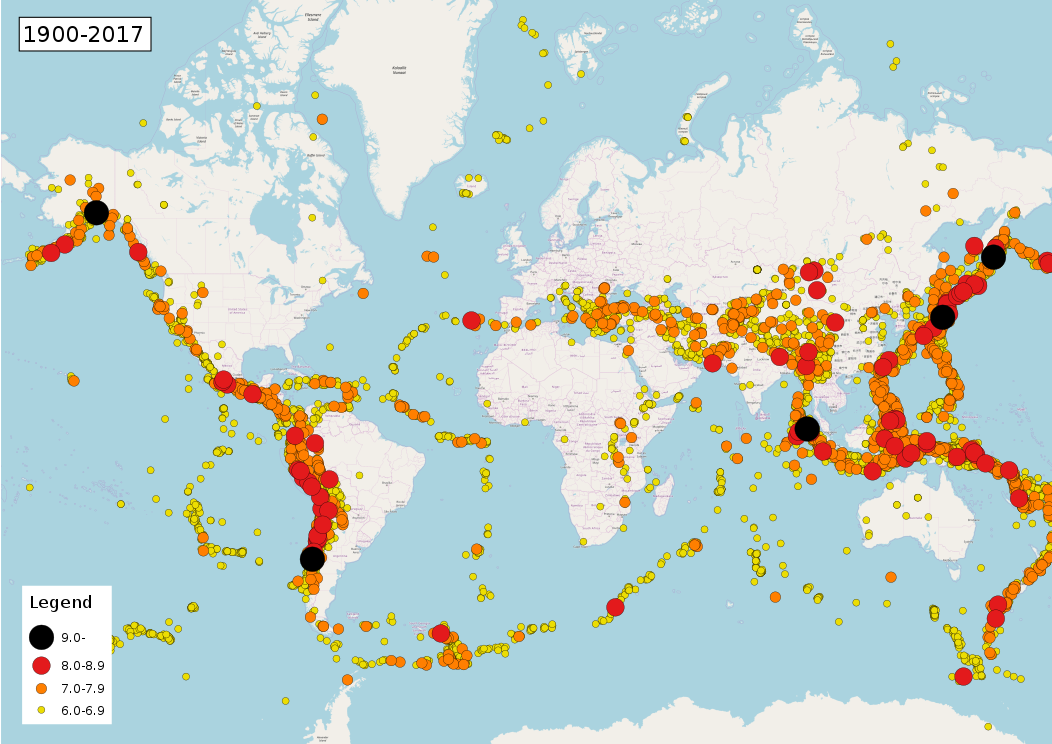
Volcanism and earthquakes are phenomena that are well known to many inhabitants of our planet. Most of the active volcanoes of the globe are in the Pacific ring of firePacific ring of fire. Volcanoes are also found in Europe, Africa, Hawaii and the Caucasus mountains.
A place where lavalava and other volcanic products escape to the surface of the continents or to the bottom of the sea is called volcano. Magma is hot, molten rocks with an admixture of large amounts of water and gases located under the surface of the ground. Lava is molten rock mass spilling onto the surface. We distinguish conical and shield volcanoes.
The largest and most powerful earthquakes (shakes of the Earth’s crust) are created at the contact zones of the lithosphere plates. The source of the seismic wave propagation has been called the focus of the earthquake. The place located directly above it on the surface of the Earth is the epicentre.
Organizing items. Set the mountains in the correct order from the oldest to the youngest.
- Sudetes
- Swietokrzyskie (Holy Cross) Mountains
- Carpathians
Organizing items. Set the Paleozoic era periods in the correct order, the oldest period should be the lowest.
- Carboniferous
- Ordovician
- Devonian
- Silurian
- Permian
- Cambrian
Make a crossword. Write down questions and answers.
Keywords
earthquake, volcano, weathering rocks
Glossary
deflacja - proces wywiewania drobnego materiału skalnego
pacyficzny pierścień ognia - strefa częstych trzęsień ziemi i erupcji wulkanów
lawa - ciekły produkt aktywności wulkanicznej
litosfera - zewnętrzna, skalna powłoka Ziemi, tworząca sztywną, ale niejednolitą (podzieloną na płyty litosferyczne) warstwę; litosfera > obejmuje skorupę ziemską oraz górną część płaszcza; jej miąższość (grubość) wynosi od kilku do ponad 100 km; nazwa litosfera pochodzi od greckiego słowa lithos, czyli 'kamień'
skorupa ziemska - górna, sztywna część litosfery o grubości od dziesięciu do kilkudziesięciu kilometrów, zbudowana z minerałów i skał
płaszcz ziemski - warstwa o grubości ok. 2,9 tys. km międzyskorupą ziemską ajądrem Ziemi
rdzeń Ziemi - najbardziej wewnętrzna część naszej planety. Obecnie uważa się, że jądro ma średnicę ok. 3,5 tys. km i jest stopem żelaza i niklu
stopień geotermiczny - głębokość (mierzona w metrach), na której temperatura wzrasta o 1°C w stosunku do punktu początkowego. Różni się w zależności od miejsca i głębokości. Średnia wartość stopnia geotermicznego w skali globalnej wynosi 33 m, zaś dla Polski 47,2 m (do głębokości 5000 m).
skała - naturalne skupisko jednego lub wielu minerałów
zasoby mineralne - skały lub minerały naturalnie występujące w środowisku, wydobywane przez człowieka dla celów gospodarczych
dolina ryftowa - ryft to podłużne obniżenie terenu długości setek lub nawet tysięcy kilometrów, leżące wzdłuż szczeliny powstającej wskutek spreadingspreading
dryft kontynentalny - ruch kontynentów względem siebie i względem powierzchni globu pod wpływem ruchu płyt litosfery, który wywołany jest prądami konwekcyjnymi w płaszczu Ziemi
góry fałdowe – góry zbudowane ze skał, które przeszły proces fałdowania w wyniku ruchu płyt litosfery i zostały wypiętrzone podczas procesów górotwórczych
góry zrębowe - góry powstałe w efekcie naprężeń w skorupie ziemskiej spowodowanych ruchami płyt litosfery; ruchy te doprowadziły do pękania i przemieszczania się mas skalnych
orogeneza (ruchy górotwórcze) – proces tektoniczny wynikający z kolizji płyt litosfery, prowadzący do tworzenia się wielkich struktur tektonicznych, m.in. gór takich, jak Alpy, Karpaty czy Himalaje
prądy konwekcyjne – powolne ruchy mas skalnych w płaszczu Ziemi, spowodowane ciepłem pochodzącym z jądra naszej planety
ryft – obniżenie terenu ograniczone co najmniej dwoma uskokami, ciągnące się na długości dziesiątek, a nawet setek kilometrów, powstałe w wyniku ruchów górotwórczych
ruchy epejrogeniczne – powolne ruchy wznoszące lub obniżające duże fragmenty skorupy ziemskiej; ruchy te nie powodują wyraźnych deformacji ani fałdowania skał
spreding – proces rozsuwania się płyt litosfery i tworzenia nowych powierzchni skorupy ziemskiej, najczęściej w dnie oceanicznym
subdukcja – proces wciągania fragmentów płyt litosfery w głąb płaszcza ziemskiego; zwykle jest to wciąganie płyty oceanicznej pod kontynentalną
Nagranie dostępne na portalu epodreczniki.pl
Nagranie słówka: theory of tectonics of the lithospheric plates
teoria tektoniki płyt litosferycznych – teoria, która tłumaczy przyczyny i skutki ruchu płyt litosfery, w tym także zjawisko dryfu kontynentów
teoria Wegenera – inna nazwa teorii dryfu kontynentówdryfu kontynentów
zrąb – deformacja mas skalnych powstająca w wyniku pionowego lub poziomego przesunięcia masywu skalnego wzdłuż rozdzielającej je płaszczyzny
blok tektoniczny – podłużne wypiętrzenie mas skalnych ograniczone co najmniej dwoma uskokami, powstałe w wyniku ruchów górotwórczych