South‑East Asia
that the components of a natural environment interact with each other;
that farming methods adapt to the conditions of the natural environment;
what the characteristics of a monsoon climate are.
to identify the geographical location of South‑East Asia;
which countries are found in this region;
what influence the monsoon climate has on the crop pattern in South‑East Asia;
what causes rice to dominate crops in South‑East Asia;
South‑East Asia – geographical location and terrain
Three regions belong to South‑East Asia. The largest is the Indochinese Peninsula, which is strongly bound to Asia's mainland. To the South, extends the Malay Peninsula with a length of 1100 km and a width ranging from just 40km to 300km. These two peninsulas have a combined surface area of 2.2 million kmIndeks górny 22. The third region is the Malay Archipelago – the largest concentration of islands on Earth (around 20 thousand). From the several dozen large islands, two stand out: Borneo with an area of 736 thousand kmIndeks górny 22 (the third largest island in terms of size in the world) and Sumatra which has an area of 435 thousand kmIndeks górny 22. As you can see, each of them is significantly larger than Poland.
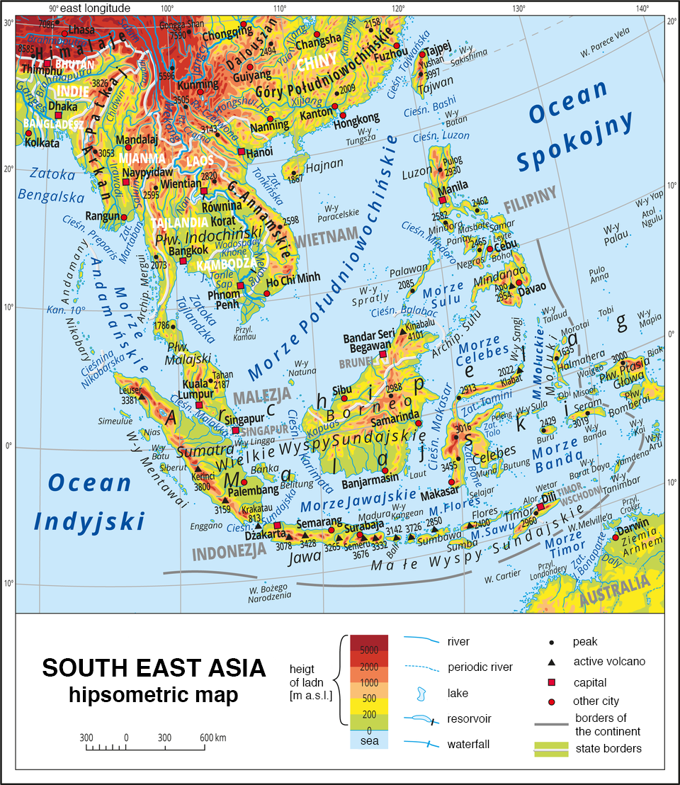
South‑East Asia is located between the Pacific Ocean to the East and the Indian Ocean to the West. The islands of the Malay Archipelago which are found on the shelf seas between Australia and Asia reach 11°S, and the northern border of the region up to 28°N (the border of Myanmar, or Burma, with China).
This region has a very highly fragmented coastline. Numerous coastal and inter‑island seas, bays, straits and archipelagos of islands occur there. This is one of the characteristics which differentiates this region from the rest of the regions in Asia.
The terrain is also distinct. The entire South‑East Asian region is seismically active, and there are numerous active volcanoes on the islands and on the ocean floor. Seperate massifs of active and extinct volcanoes are a feature of the terrain on many of the islands. The Malay Archipelago is located on the edge of the Eurasian lithospheric plate. Deep sea trenches occur on the ocean floor – the deepest is the Phillipine Trench, which reaches 10 830 metres below sea level.
Using the knowledge you have acquired, solve Exercise 1
South‑East Asia – political division
South‑East Asia is divided into a dozen or so states, which differ greatly between themselves. The differences between the countries concern geographical locations, surface areas and terrains, populations and their traits (ethnic, religious, cultural) and economies.
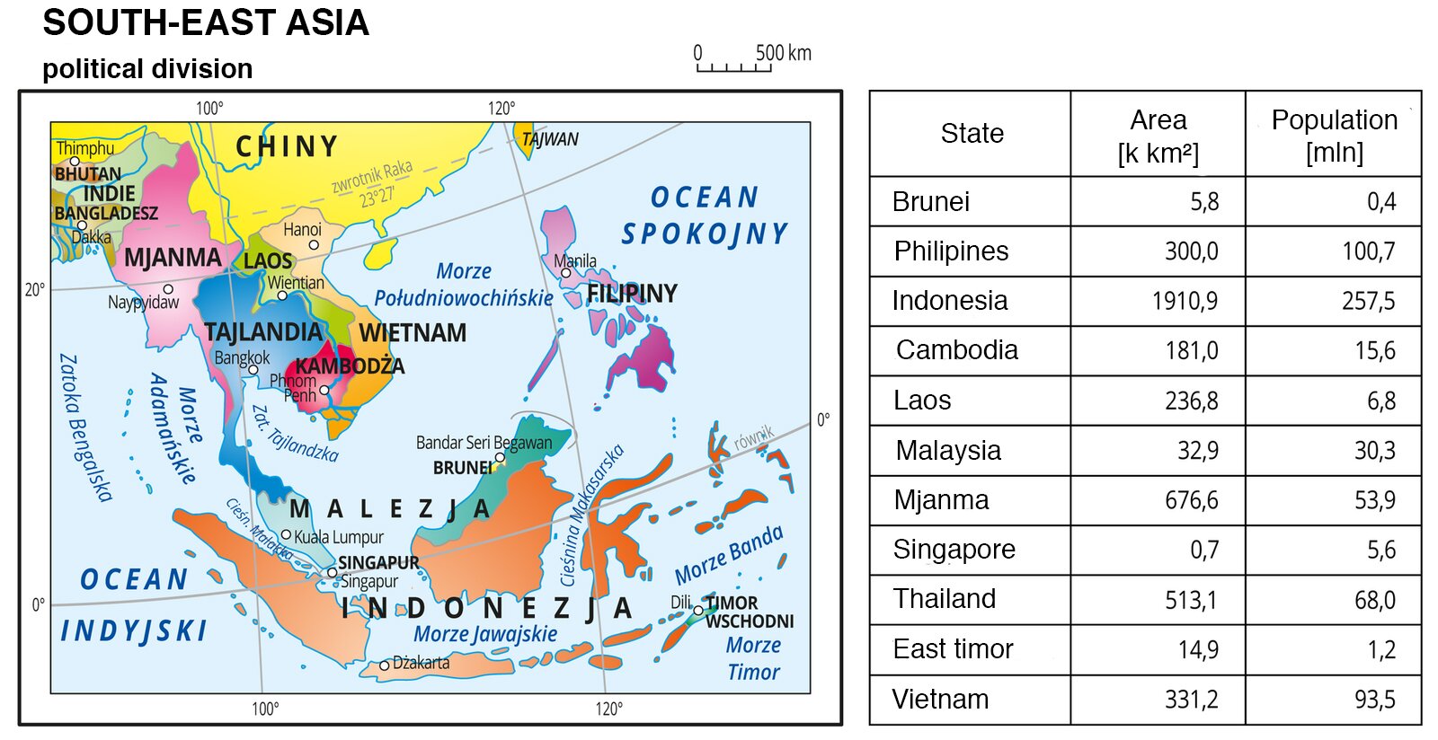
The largest country in South‑East Asia in terms of surface area is Indonesia, which has an area of 1 million 914 thousand kmIndeks górny 22. It is also the most populous country in the region – 257.5 million inhabitants puts Indonesia at 4th place in the world in this respect. Other countries with a large population are: The Philippines – 100.7 million, Vietnam – 93.5 million and Thailand 68.0 million (all data are from 2015). The combined land area of all of the South‑East Asian countries measures 4.5 million kmIndeks górny 22, and the combined population is over 600 million.
The map below contains information about the capitals of South‑East Asian countries. Read the information below.
South‑East Asia – agriculture
Two types of climate occur in South‑East Asia:
a humid tropical climate – a monsoon climate – which prevails in the central and northern part of the region;
an extremely humid equatorial climate which prevails in the southern part.
One common trait of both types of climate is a high air temperature year‑round. The yearly total precipitation is also high: from 1500 mm to 2500 mm, but its range varies throughout the course of the year. The yearly total of precipitation in equatorial climates is even. In a monsoon climate, two seasons of precipitation occur: in the period from December to April, there is low precipitation and from May to November – high.
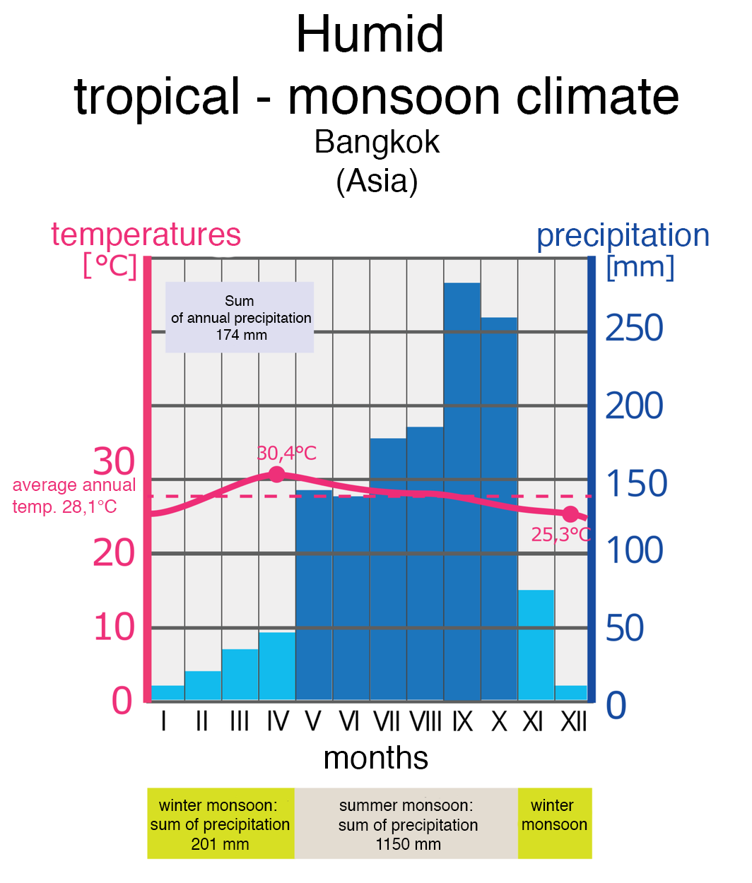
The features of South‑East Asia's climate allow plants to grow all year round. They have also influenced the creation of a specific type of irrigated agriculture in this region.
Rice cultivation requires a great amount of work. Preparing the seedlings, flooding the fields with water and collecting the plants when the grains have matured have led to the formation of certain behaviours called rice culture. These behaviours influence farming methods and the ties between people.
In South‑East Asia, rice is cultivated in small fields, and most of the work is carried out by hand. Animal power is used on flat terrains located in river valleys and river deltas. In mountain areas, slope terracing is used in order to obtain a larger cultivated area. On extremely steep slopes the terraces are narrow and on gentle slopes they are wider, sometimes reaching 50 m. All work on narrow terraces is carried out by hand. Water is led to the fields from mountain streams via trenches, sometimes from long distances, and then distributed with the help of channels, trenches or hollow pipes made of wood or bamboo stems. First, rice is sown in seedbeds in which the soil is carefully prepared: it is crumbled and moistened until it reaches the consistency of thin mud. Next, it is fertilised with animal fertiliser, faeces, silt from ponds and aquatic vegetation. This hard work is carried out alongside relations, neighbours and sometimes entire rural communities participate. After 20–30 days, the seedlings are transported to the appropriate field, at which time the rice plant is flooded. The level of water, however, must be constantly monitored. An important factor which influences the size of harvests is people's experience and the long‑standing tradition of rice cultivation.
2 weeks before harvest, the water is drained from the fields, which helps the grains to ripen faster. The rice harvest and the threshing and peeling of grains is also hard work and is often done by hand. In many regions of South‑East Asia, climate conditions guarantee a constant growing season, which allows for at least two rice harvests a year. In periods of lower precipitation, the fields are often used to grow plants which do not require irrigation.
Rice is the most important crop in all South‑East Asian countries, occupying the largest area, and acting as a staple grain used for human nourishment. China and India – great producers of rice, are also the two most populous countries on Earth.
To better understand the issues raised in the lesson, analyse the charts: main producers of rice, a map depicting rice harvests.
Complete exercise 2 from the e‑textbook.
Put the names of the islands and peninsulas which have been marked on the chart below.
Indochinese Peninsula, Sumatra, Malay Peninsula, Java, Island of Borneo
Order the South-East Asian states in terms of their population, from the highest to the lowest number.
- Vietnam
- Myanmar
- Thailand
- The Philippines
- Indonesia
Keywords
Asia, rice culture, monsoon climate
Glossary
kultura ryżowa – charakterystyczne zachowania społeczne związane ze wspólną uprawą, przygotowaniem i utrzymaniem pól.
monsun – układ wiatrów, które zmieniają swój kierunek na przeciwny w zależności od pory roku. Są to wiatry sezonowe wiejące między oceanem a lądem. Wyróżniamy monsun letni i monsun zimowy.