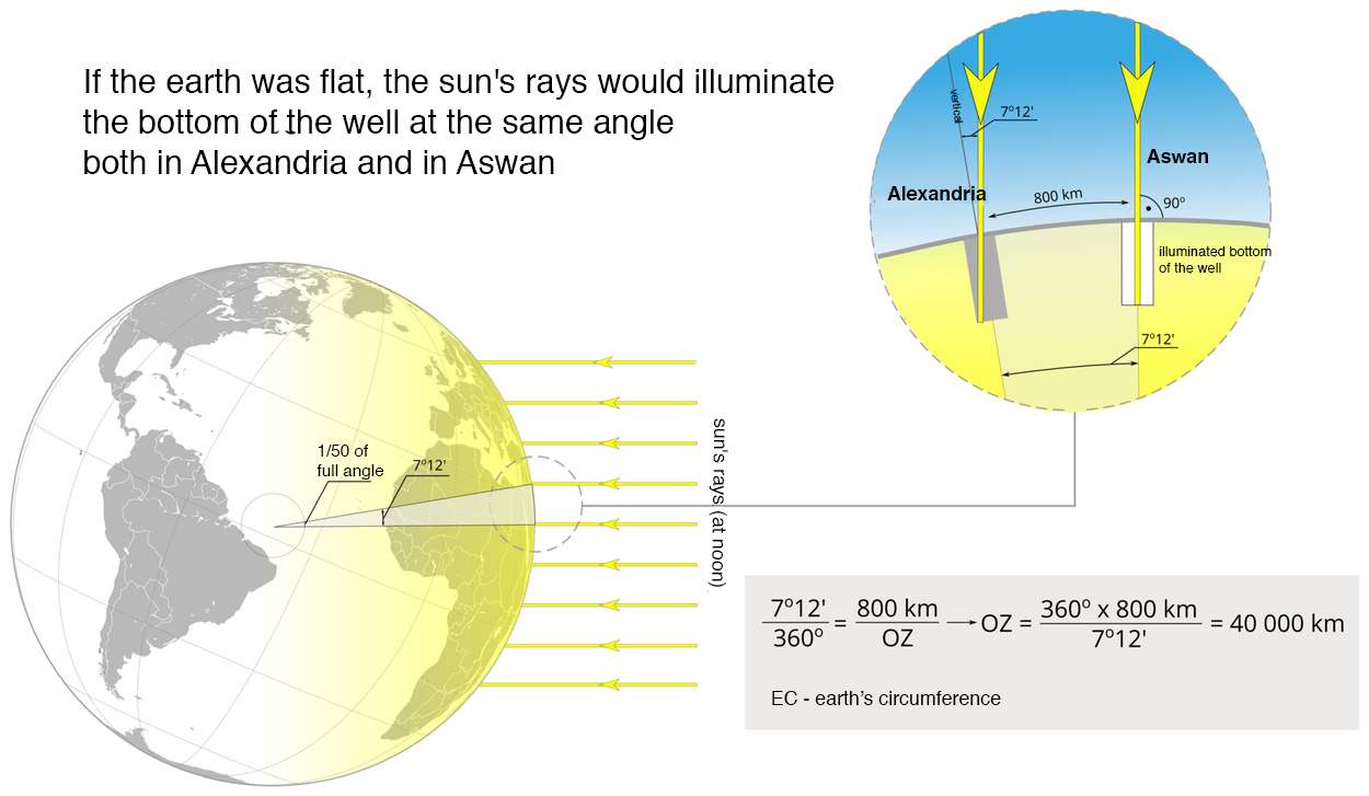
Upon thousands of years of perceiving the Earth as a flat object, people finally concluded (as a result of many observations, calculations and reasoning attempts) that our planet is a sphere or a solid closely resembling a sphere. The first successful attempt to determine the Earth’s size was completed by Eratosthenes, a philosopher, a geographer, an astronomer and a mathematician of Greek origin, living most of his life in Egypt. He compared lengths of shadows cast at noon during the summer solstice in two Egyptian locations which, as he had presumed, lied on the same meridian: Syene (modern Aswan, south Egypt) and Alexandria (at the shore of the Mediterranean Sea). When sun rays lit the bottom of a deep well in Aswan (which means they were perpendicular to the Earth’s surface), in Alexandria they fell under the angle of 7.2 degrees (which is 7.2/360 or 1/50 of a full angle). Eratosthenes measured that the distance between these locations was about 800 km (497 mi) (in modern units of length). He concluded that the Earth’s circumference should be 50 times that which was about 40,000 km (24,855 mi). This is astonishingly close to modern measurements of the Earth’s circumference according to which it measures 40,075.017 km (24,901 mi), and the average radius is 6,371.0 km (3959 mi).
R2j6rBoqTZztd
Schemat ilustrujący pomiary Eratostenesa. Po lewej, na górze napis: If the Earth was flat, the sun’s rays would illuminate the bottom of the well at the same angle both in Alexandria and in Aswan. Pod napisem kula ziemska oświetlona promieniami słonecznymi. Po prawej, na górze, wycinek kuli ziemskiej. Zaznaczono na nim studnie w Aleksandrii i Asuanie oraz dzielącą je odległość, wynoszącą 800 kilometrów. Na dno studni w Aleksandrii padają promienie słoneczne pod kątem 7 stopni 12 minut. Dno studni w Asuanie oświetlone promieniami słonecznymi skierowanymi prostopadle do powierzchni Ziemi, czyli pod kątem 90 stopni (illuminated bottom of the well). Poniżej działania matematyczne: 7 stopni 12 minut dzielone przez 360 stopni równa się 800 kilometrów dzielone przez OZ, przy czym OZ oznacza obwód Ziemi; więc: OZ równa się 360 stopni razy 800 kilometrów dzielone przez 7 stopni 12 minut, równa się 40000 kilometrów.
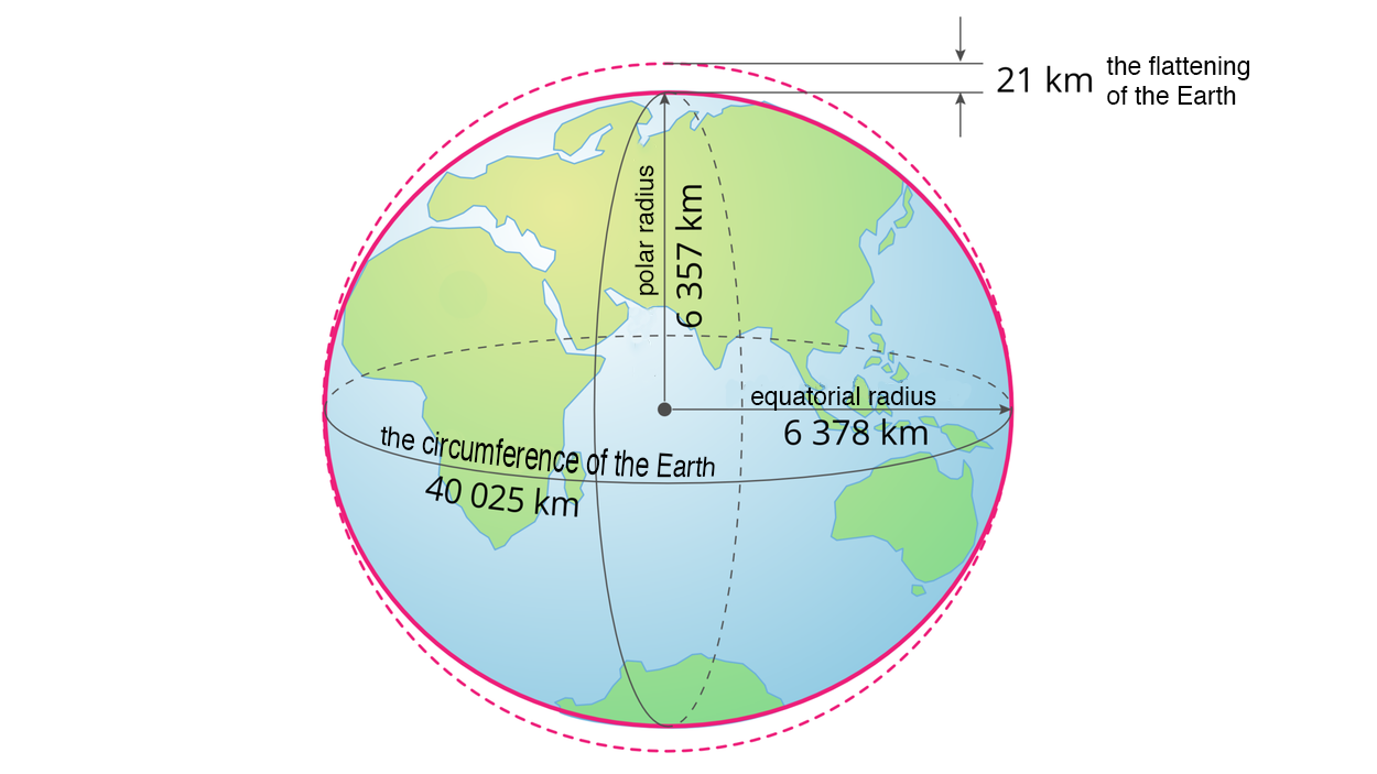
The Earth is not an ideal sphere. The Earth’s rotation around its own axis results in a centrifugal force which acts the strongest on the equator and makes the Earth’s radius, measured from its centre to the equator (ca. 6,378 km / 3963 mi), to be greater than the radius measured from its centre to the pole (ca. 6,357 km / 3950 mi). Such a solid is called a rotational ellipsoidrotational ellipsoidrotational ellipsoid Due to the fact that land elevates from the ocean level, the Earth’s shape is neither an ideal sphere nor it is an ideal rotational ellipsoid. This is a shape typical exclusively for our planet, with no equivalent in geometric solids, and therefore called a geoidgeoidgeoid.
R16d6KJI7Q0fQ
Ilustracja przedstawiająca Ziemię o kształcie zbliżonym do elipsoidy obrotowej, czyli kuli lekko spłaszczonej na biegunach. Na ilustracji zaznaczono: obwód Ziemi (the circumference of the Earth) wynoszący 40025 kilometrów, promień biegunowy (polar radius) wynoszący 6357 kilometrów, promień równikowy (equatorial radius) wynoszący 6378 kilometrów oraz różnicę między promieniami wynoszącą 21 kilometrów, odpowiadającą spłaszczeniu Ziemi (the flattening of the Earth).
Elipsoida
Source: Andrzej Bogusz, licencja: CC BY-NC 3.0.
Task 1
Work in groups.
RBtrCgA2ecqSK
Using a globe or maps in a geographical atlas, estimate the value of the angle at the midday of the summer solstice formed by the direction of the sunrays in Aswan with the direction of sunrays (same day and time) in Kiev or another European city near the same meridian as Aswan. (Uzupełnij). Measure the distance between these places, e.g. using Google Maps. (Uzupełnij). Based on Eratosthenes' calculations, calculate the Earth's circumference based on the data obtained for Aswan and the selected European city. (Uzupełnij).
Using a globe or maps in a geographical atlas, estimate the value of the angle at the midday of the summer solstice formed by the direction of the sunrays in Aswan with the direction of sunrays (same day and time) in Kiev or another European city near the same meridian as Aswan. (Uzupełnij). Measure the distance between these places, e.g. using Google Maps. (Uzupełnij). Based on Eratosthenes' calculations, calculate the Earth's circumference based on the data obtained for Aswan and the selected European city. (Uzupełnij).
R6nUwnAcxOKD0
Animacja przedstawiająca związek pomiędzy siłą odśrodkową a kształtem ciała niebieskiego. Na ekranie kręcąca się planeta Ziemia widziana z kosmosu. Następnie rysunek kuli z zaznaczonym kierunkiem obracania, osią obrotu, siłą odśrodkową działającą na kulę i promieniami zaznaczonymi w dwóch miejscach: pośrodku kuli i bliżej bieguna północnego. Promień bliżej bieguna r = jedna druga R, promień pośrodku r = R. Zaznaczony wektor siły F przy biegunie krótszy niż pośrodku kuli. Na ekranie napis: R – average radius of the Earth, r – distance between the axis of rotation of the Earth and the point on its surface, F – centrifugal force acting at a given point on the Earth’s surface. W kolejnym ujęciu znów kręcąca się Ziemia widziana z kosmosu. Po prawej i po lewej stronie Ziemi pojawiają się strzałki wskazujące kierunek działania siły odśrodkowej. Ziemia ulega niewielkiemu spłaszczeniu, strzałki wydłużają się.
Animacja przedstawiająca związek pomiędzy siłą odśrodkową a kształtem ciała niebieskiego. Na ekranie kręcąca się planeta Ziemia widziana z kosmosu. Następnie rysunek kuli z zaznaczonym kierunkiem obracania, osią obrotu, siłą odśrodkową działającą na kulę i promieniami zaznaczonymi w dwóch miejscach: pośrodku kuli i bliżej bieguna północnego. Promień bliżej bieguna r = jedna druga R, promień pośrodku r = R. Zaznaczony wektor siły F przy biegunie krótszy niż pośrodku kuli. Na ekranie napis: R – average radius of the Earth, r – distance between the axis of rotation of the Earth and the point on its surface, F – centrifugal force acting at a given point on the Earth’s surface. W kolejnym ujęciu znów kręcąca się Ziemia widziana z kosmosu. Po prawej i po lewej stronie Ziemi pojawiają się strzałki wskazujące kierunek działania siły odśrodkowej. Ziemia ulega niewielkiemu spłaszczeniu, strzałki wydłużają się.
Animacja przedstawiająca związek pomiędzy siłą odśrodkową a kształtem ciała niebieskiego. Na ekranie kręcąca się planeta Ziemia widziana z kosmosu. Następnie rysunek kuli z zaznaczonym kierunkiem obracania, osią obrotu, siłą odśrodkową działającą na kulę i promieniami zaznaczonymi w dwóch miejscach: pośrodku kuli i bliżej bieguna północnego. Promień bliżej bieguna r = jedna druga R, promień pośrodku r = R. Zaznaczony wektor siły F przy biegunie krótszy niż pośrodku kuli. Na ekranie napis: R – average radius of the Earth, r – distance between the axis of rotation of the Earth and the point on its surface, F – centrifugal force acting at a given point on the Earth’s surface. W kolejnym ujęciu znów kręcąca się Ziemia widziana z kosmosu. Po prawej i po lewej stronie Ziemi pojawiają się strzałki wskazujące kierunek działania siły odśrodkowej. Ziemia ulega niewielkiemu spłaszczeniu, strzałki wydłużają się.
R1FESnmhRO3rS
Exercise 1
Based on lessons, choose sentences which are true. Możliwe odpowiedzi: 1. Eratosthenes was the first to calculate the Earth’s circumference with surprisingly good accuracy., 2. Eratosthenes compared lengths of shadows cast at noon during the summer solstice in two towns which, as he had presumed, lied on the same meridian., 3. If the Earth was flat, then, at the same time, sun rays would fall on its surface at the same angle in all towns lying on the same meridian., 4. According to measurements he had completed, Eratosthenes hypothesised that the Earth is flat, and this opinion survived until today.
Based on lessons, choose sentences which are true. Możliwe odpowiedzi: 1. Eratosthenes was the first to calculate the Earth’s circumference with surprisingly good accuracy., 2. Eratosthenes compared lengths of shadows cast at noon during the summer solstice in two towns which, as he had presumed, lied on the same meridian., 3. If the Earth was flat, then, at the same time, sun rays would fall on its surface at the same angle in all towns lying on the same meridian., 4. According to measurements he had completed, Eratosthenes hypothesised that the Earth is flat, and this opinion survived until today.
Based on lessons, choose sentences which are true.
Eratosthenes was the first to calculate the Earth’s circumference with surprisingly good accuracy.
Eratosthenes compared lengths of shadows cast at noon during the summer solstice in two towns which, as he had presumed, lied on the same meridian.
If the Earth was flat, then, at the same time, sun rays would fall on its surface at the same angle in all towns lying on the same meridian.
According to measurements he had completed, Eratosthenes hypothesised that the Earth is flat, and this opinion survived until today.
RLxgL6dV6Gq1Y
Exercise 2
Match each effect with corresponding cause. Causes: Earth’s rotation, centrifugal force effect, spherical shape of the Earth. Effects: 1. generation of centrifugal force, 2. varied shadow length in different locations lying at the same meridian, 3. flattening of the Earth’s poles
Match each effect with corresponding cause. Causes: Earth’s rotation, centrifugal force effect, spherical shape of the Earth. Effects: 1. generation of centrifugal force, 2. varied shadow length in different locations lying at the same meridian, 3. flattening of the Earth’s poles
Match each effect with corresponding cause.
flattening of the Earth’s poles, varied shadow length in different locations lying at the same meridian, generation of centrifugal force
elipsoida obrotowa - bryła powstająca przez obrót elipsy wokół jednej z jej osi; elipsoida Ziemi powstaje w wyniku obrotu elipsy wokół krótszej osi, jaką jest oś ziemska
geoida - bryła obrazująca kształt Ziemi, niemająca odpowiednika w bryłach geometrycznych; jej powierzchnia w każdym miejscu jest prostopadła do kierunku działania siły ciężkości; kształt geoidy jest zbliżony do rzeczywistego kształtu Ziemi