New technologies which enabled deep‑sea travel were discovered in the 15th century. Navigation devices were invented. More accurate maps were developed. New types of vessels were built (e.g. three‑mast caravelscaravelcaravels and carrackscarrackcarracks).
RINnKik0e8kch1
Obraz przedstawiający domniemany portret Krzysztofa Kolumba. Jest to mężczyzna w starszym wieku. Ma smutną zmęczoną twarz, podkrążone oczy. Ma kręcone włosy. Ubrany jest w czarną szatę i białą koszulę. Lewą rękę trzyma na piersiach.
Alleged portrait of Christopher Columbus
Source: Sebastiano del Piombo, Portrait of a Man, Said to be Christopher Columbus, 1519, oil on canvas, domena publiczna.
The desire for profit is at the root of the great geographical discoveries. The Spanish and Portugese rulers tried to find a seaway to India in order to pass over the land route leading through the lands controlled by Muslim Turks. For this purpose, in 1492 an expedition set off under the command of Christopher Columbus. He reached the coast of a new continent, later called America or the New WorldNew WorldNew World. Columbus was not aware of the importance of his discovery until the end of his life. He believed that he had actually arrived in India. That is why the indigenous inhabitants of the New World were called Indians. In the years 1519–1522, Ferdinand Magellan's expedition took place, proving the roundness of the globe.
Task 1
Read the text carefully and answer the questions:
Why did great geographical discoveries take place?
What did Europeans search for in remote lands?
Portuguese and Spanish merchants wanted to find a new way to India and the countries of the East in order to import goods sought in Europe cheaply from there. They were particularly interested in maritime routes, because land trade routes became expensive and dangerous. Land routes were captured by the Turks, who imposed high charges on the carried goods. Thanks to merchants and travelers, the Europeans’ geographical knowledge became more and more extensive. Stories about distant countries stimulated their imagination. Europeans imagined that unknown lands were full of gold and silver, and anyone who came to them would become a rich person. At the beginning of the 15th century, the Portuguese moved to the coast of Africa, from where they imported ivory and gold. Long‑distance sea expeditions were therefore an opportunity to gain fame and property.
Exercise 1
Read the text and then do the exercise.
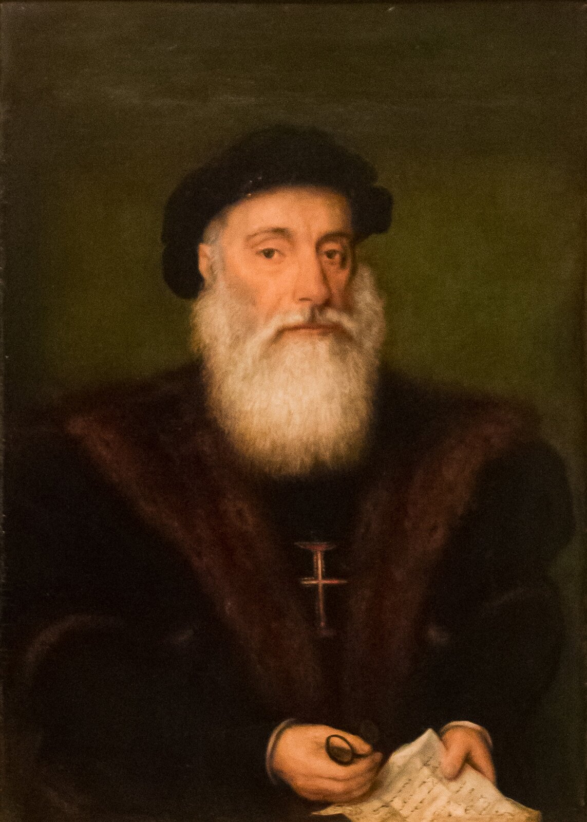
RDwZW8xTKvjFa1
Obraz przedstawiający postać Vasco da Gama. Jest to starszy człowiek z długą siwą brodą i długimi siwymi wąsami. Ubrany jest w czarną czapkę, oraz czarną szatę, ma na piersiach krzyż. W dłoniach trzyma kartkę papieru.
Alleged portrait of Vasco da Gama
Source: Gregório Lopes, Vasco da Gama, oil on oak panels, domena publiczna.
Alvaro VelhoRelacja z wyprawy Vasco da Gamy do Indii
„Szlachcic z waszego dworu przybył do mojego kraju, czemu jestem rad. W moim kraju jest dużo cynamonu, goździków, imbiru, pieprzu i drogich kamieni. Z twojego kraju chciałbym dostać złoto, srebro, korale i szkarłat [czerwony barwnik]”.
velho Source: Alvaro Velho, Relacja z wyprawy Vasco da Gamy do Indii, Gdańsk 1996.
R1Vjchu5skSZO
Indicate what Europeans were looking for in India. What did the people of India expect in return? What did Europeans search for? Możliwe odpowiedzi: 1. coral, 2. gold, 3. ginger, 4. pepper, 5. silver, 6. cinnamon, 7. scarlet, 8. cloves What did the people of India want from Europeans? Możliwe odpowiedzi: 1. coral, 2. gold, 3. ginger, 4. pepper, 5. silver, 6. cinnamon, 7. scarlet, 8. cloves
Indicate what Europeans were looking for in India. What did the people of India expect in return? What did Europeans search for? Możliwe odpowiedzi: 1. coral, 2. gold, 3. ginger, 4. pepper, 5. silver, 6. cinnamon, 7. scarlet, 8. cloves What did the people of India want from Europeans? Możliwe odpowiedzi: 1. coral, 2. gold, 3. ginger, 4. pepper, 5. silver, 6. cinnamon, 7. scarlet, 8. cloves
Indicate what Europeans were looking for in India. What did the people of India expect in return?
Familiarize yourself with old navigation devices and ships used by geographical discoverers.
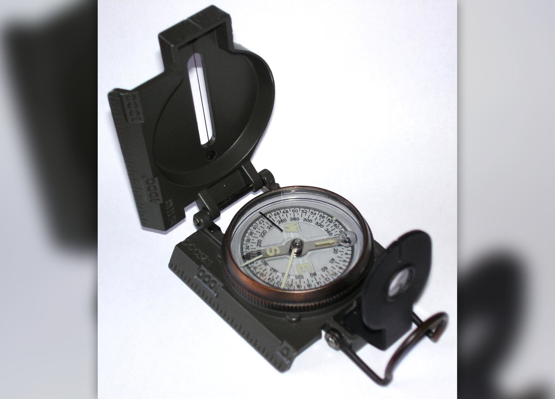
R17WBpwN065eQ
Fotografia przedstawia przyrząd do pomiaru kierunków świata - busolę
Magnetic compass - a navigation device used to determine the direction of the magnetic pole. Magnetic compass, similarly to a common compass, is equipped with a magnetic needle. The difference between the magnetic compass and the common compass is that the magnetic compass has an aiming device that helps to determine the azimuth.
Source: Nicolas Kaiser, Wikimedia Commons, licencja: CC BY-SA 2.0.
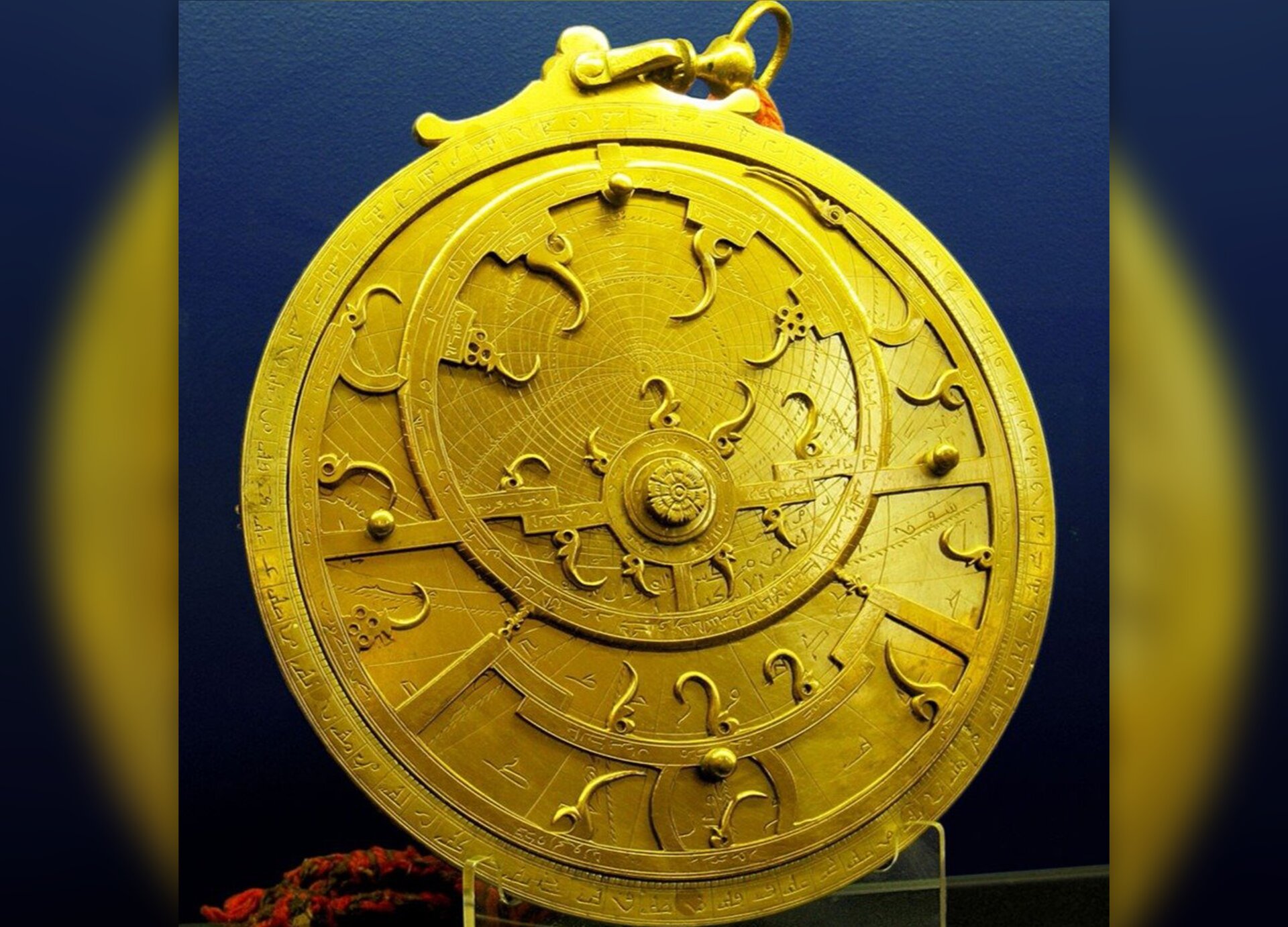
R1C4pP1mIx89t
Fotografia przedstawia przyrząd pomiarowy astronomiczny - astrolabium.
Astrolabe is an astronomical measuring instrument used in navigation until the beginning of the 18th century to determine the position of celestial bodies above the horizon, the predecessor of sextant.
Source: Andrew Dunn, licencja: CC BY-SA 2.0, [online], dostępny w internecie: http://commons.wikimedia.org.
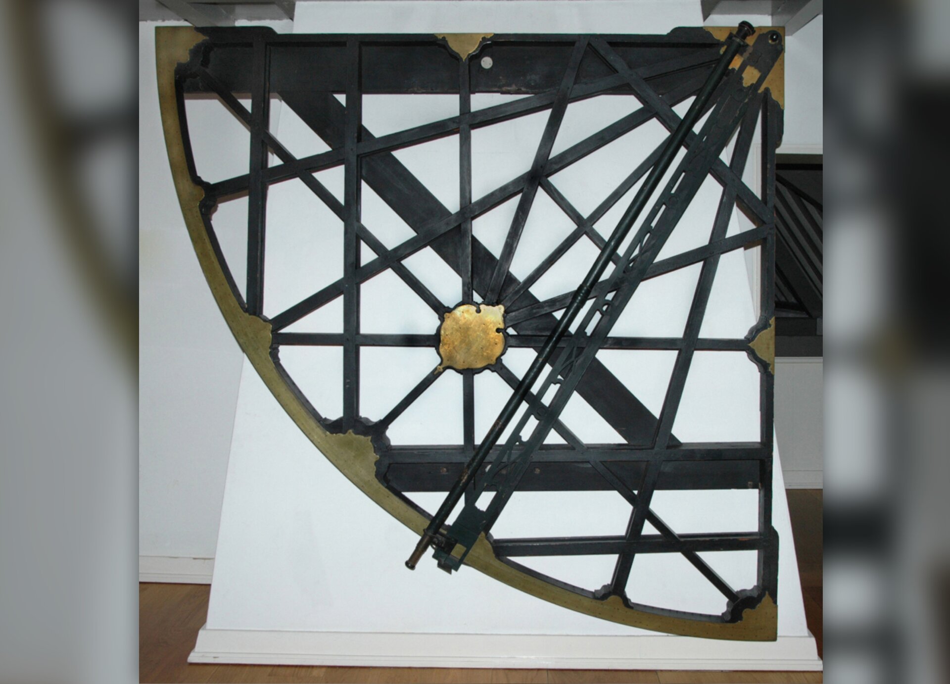
R11AnZmvutTWH
Fotografia przedstawia przyrząd do wyznaczania położenia geograficznego - kwadrant.
Quadrant is an old instrument for determining the position of stars. In maritime navigation, a simple quadrant was used parallel with Jacob's staff until the end of the 16th century. Some early quadrants had marked latitudes of important ports instead of graduation in degrees.
Source: Jos van den Broek, licencja: CC BY-SA 3.0, [online], dostępny w internecie: http://commons.wikimedia.org.
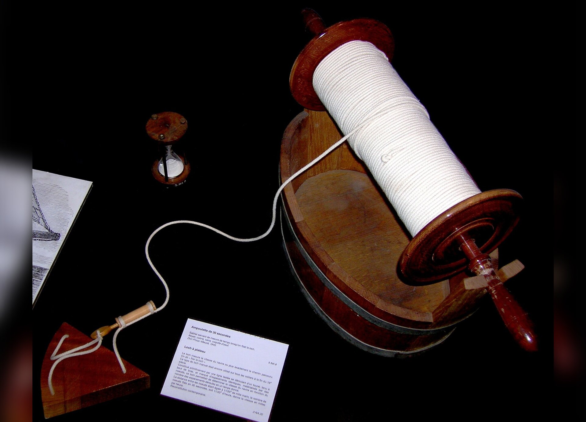
R3SJEKASZ5pWt
Fotografia przedstawia przyrząd pomiarowy określający prędkość poruszania się statku - log.
Chip log is a measuring instrument that measures the speed and distance traveled of a vessel.
Source: Rémi Kaupp, licencja: CC BY-SA 3.0, [online], dostępny w internecie: http://commons.wikimedia.org.
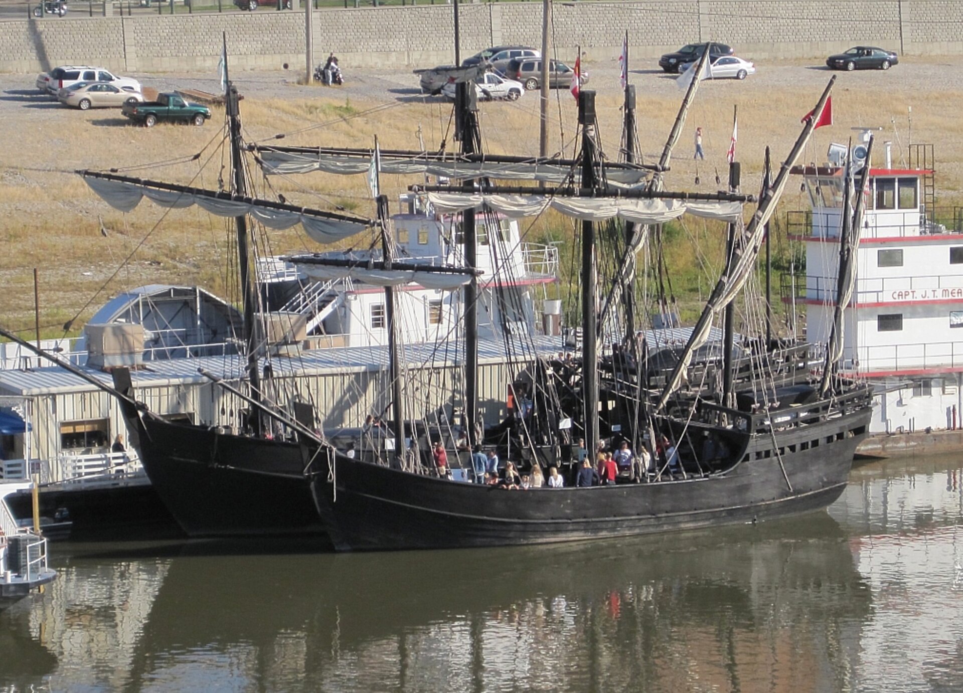
R1K7NUyo5sliv
Fotografia przedstawia żaglowiec.
Replica of La Pinta
Source: Thomas R. Machnitzki, Wikimedia Commons, licencja: CC BY-SA 3.0.
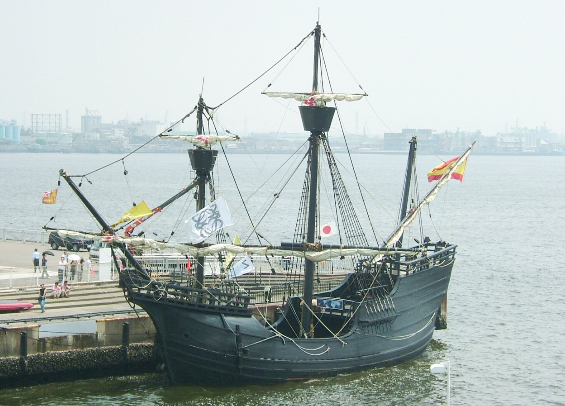
RUgqlYDIrV57k
Fotografia przedstawia żaglowiec pod hiszpańską banderą.
Replica of the Victoria, Magellan's carrack
Source: Gnsin, Wikimedia Commons, licencja: CC BY-SA 3.0.
Exercise 2
Wysłuchaj nagrania abstraktu, ułóż do niego pytania i zadaj je koledze.
Wysłuchaj nagrania abstraktu, ułóż do niego pytania i zadaj je koledze.
Read the text and then do the exercise.
The picture below shows a carrackcarrackcarrack, one of the ships (“Santa Maria”) on which Christopher Columbus set off on his expedition. It had square rigs on its front and on the main mast. Latin‑rig was on the rear mast. The larger sail area allowed the carrackscarrackcarracks to achieve a higher speed and thus a greater range. On the main mast, there was an observation point – mars, popularly called the crow's nest.
RJGM3ryM9Eox4
Fotografia przedstawia model karaki. Trzymasztowy okręt wykonany z drewna. Ma zaokrągloną rufę z wysoką nadbudowką zwaną kasztelem, oraz drugą, niższą, na dziobie. Na żaglach widnieje symbol czerwonego krzyża.
Fotografia przedstawia model karaki. Trzymasztowy okręt wykonany z drewna. Ma zaokrągloną rufę z wysoką nadbudowką zwaną kasztelem, oraz drugą, niższą, na dziobie. Na żaglach widnieje symbol czerwonego krzyża.
Model karaki "Santa Maria"
Source: domena publiczna.
Exercise 3
Analyze the route of the first voyage of Columbus and do the exercise.
Analyze the route of the first voyage of Columbus and do the exercise.
Look at the map and then do the exercise.
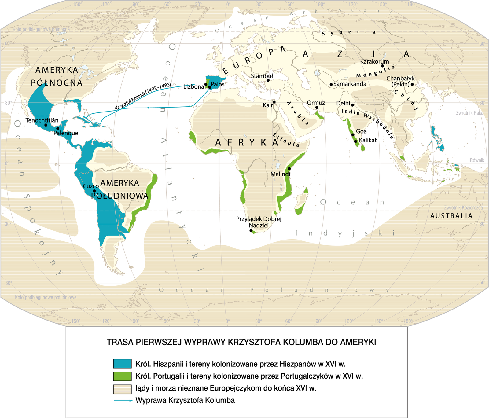
RdPEpRyiNAUc7
Mapa prezentuje przebieg pierwszej wyprawy Kolumba. Podróż rozpoczyna się w Palos w Portugalii, na południu półwyspu iberyjskiego. Pierwszym etapem były Wyspy Kanaryjskie. Następnie wyprawa dociera do wysp Bahama. Następnie na Kubę, a potem na Haiti. W 1493 roku Kolumb wraca do Palos.
The route of the first expedition of Christopher Columbus to America.
Source: licencja: CC BY 3.0.
R1Uo6nD6obG6D
Which of these sentences are true? Columbus sailed westward.
Columbus set off from Spain.
Columbus sailed through the Indian Ocean.
During his first journey, Columbus reached islands close to the American continent.
Which of these sentences are true? Columbus sailed westward.
Columbus set off from Spain.
Columbus sailed through the Indian Ocean.
During his first journey, Columbus reached islands close to the American continent.
Mark the following sentences as true or false.
During his first journey, Columbus reached islands close to the American continent., Columbus sailed westward., Columbus sailed through the Indian Ocean., Columbus set off from Spain.
true
false
Exercise 4
Read the text and then do the exercise.
Jan KieniewiczListy o odkryciu Ameryki
W przeciągu 33 dni dopłynąłem z Wysp Kanaryjskich do Indii, z flotą, jaką powierzyli mi najmiłościwiej panujący Król i Królowa [Ferdynand i Izabela]. Znalazłem wielką obfitość wysp zamieszkanych przez niezliczone rzesze ludzi. Wszystkie je zająłem w imieniu Ich Wysokości. Obwieściłem to przy rozwiniętym sztandarze, a nikt się nie sprzeciwił.
kieniewicz Source: Jan Kieniewicz, Listy o odkryciu Ameryki, Gdańsk 1995.
RqJ9QR3T4EbCx
Which of these sentences are true?
Columbus set off on a cruise from the Canary Islands.
Columbus discovered plenty of islands.
The islands discovered by Columbus were deserted.
When discovering new lands inhabited by pagans, the Europeans believed that they were becoming owners thereof.
Columbus's journey lasted less than a month.
Columbus believed that the discovered islands were owned by the King and the Queen of Spain.
Mark the following statements as true or false.
When discovering new lands inhabited by pagans, the Europeans believed that they were becoming owners thereof., Columbus set off on a cruise from the Canary Islands., The islands discovered by Columbus were deserted., Columbus's journey lasted less than a month., Columbus discovered plenty of islands., Columbus believed that the discovered islands were owned by the King and the Queen of Spain.
true
false
Exercise 5
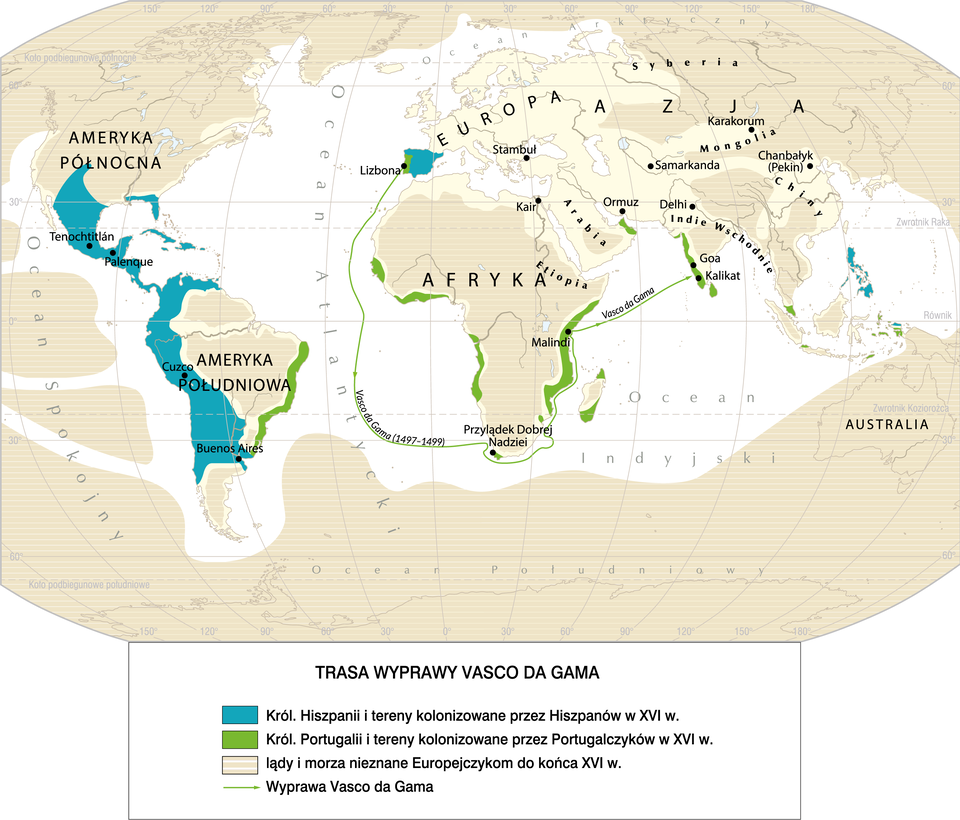
Analyze the route of Vasco Da Gama's voyage and do the exercise.
Analyze the route of Vasco Da Gama's voyage and do the exercise.
Look at the map and then do the exercises.
R1IEHTvev6roi
Mapa prezentuje przebieg wyprawy Vasco da Gama. Podróż rozpoczyna się w Lizbonie w Portugalii. Pierwszym etapem jest opłynięcie Afryki od południa, miajając Przylądek Dobrej Nadziei. Następnie dopłynął do Malindi, na wschodnim wybrzeżu kontynentu, po czym popłynął do zachodniego wybrzeża Indii.
Expedition trail of Vasco Da Gama.
Source: Contentplus.pl sp. z o.o., licencja: CC BY 3.0.
RAl808mT3yoKz
Which of these sentences are true?
Vasco da Gama first came to India and then sailed around Africa.
Vasco da Gama reached the Cape of Good Hope in the south of Africa.
Vasco da Gama’s ship sailed to India.
Which of these sentences are true?
Vasco da Gama first came to India and then sailed around Africa.
Vasco da Gama reached the Cape of Good Hope in the south of Africa.
Vasco da Gama’s ship sailed to India.
Mark the following sentences as true or false.
Vasco da Gama’s ship sailed to India., Vasco da Gama reached the Cape of Good Hope in the south of Africa., The map shows the route of the Vasco da Gama’s expedition., Vasco da Gama first came to India and then sailed around Africa.
true
false
Exercise 6
Analyze the route of Magellan's voyage and do the exercise.
Analyze the route of Magellan's voyage and do the exercise.
Look at the map and then do the exercises.
R9aMe6IWd7Rjz
Mapa prezentuje przebieg wyprawy Magellana. Podróż rozpoczyna w Sewilli w Hiszpanii. Odkrywca płynie na południowy-zachód, docierając do Buenos Aires w Ameryce Południowej. Następnie opływa kontynent od południa, przez dzisiejszą Cieśninę Magellana i płynie na dzisiejsze Filipiny, gdzie umiera w 1521 roku. Od tego momentu wyprawa trwa pod przewodnictwem Juana Sebastiána Elcaño, który płynie na południe przez wody dzisiejszej Indonezji, po czym kieruje się na zachód przez Ocean Indyjski. Opływa Afrykę od południa, mija Przylądek Dobrej Nadziei i wraca do Hiszpanii.
Expedition route of Ferdinand Magellan.
Source: licencja: CC BY 3.0.
Ru7UmvWJDlLXk
Arrange the stages of the Magellan’s journey in the correct order. Elementy do uszeregowania: 1. Spain – set off, 2. Philippines, 3. Indonesia, 4. The Cape of Good Hope, 5. Spain – return, 6. Indian Ocean, 7. South America and the Strait of Magellan, 8. Atlantic Ocean
Arrange the stages of the Magellan’s journey in the correct order. Elementy do uszeregowania: 1. Spain – set off, 2. Philippines, 3. Indonesia, 4. The Cape of Good Hope, 5. Spain – return, 6. Indian Ocean, 7. South America and the Strait of Magellan, 8. Atlantic Ocean
Arrange the stages of the Magellan’s journey in the correct order.
Philippines
Spain – return
Indian Ocean
Atlantic Ocean
Spain – set off
South America and the Strait of Magellan
The Cape of Good Hope
Indonesia
R13ptRg3YCf96
Exercise 7
Complete the sentences with the words listed below. At the end of the {tu uzupełnij} Możliwe odpowiedzi: 1. 15th, 2. Ferdinand Magellan, 3. Christopher Columbus, 4. 1492, 5. geographical, 6. vessels century, Europeans discovered new unknown lands on three continents: Asia, Africa and America. The discoveries were made possible thanks to development of {tu uzupełnij} Możliwe odpowiedzi: 1. 15th, 2. Ferdinand Magellan, 3. Christopher Columbus, 4. 1492, 5. geographical, 6. vessels sciences, interest in the world and advances in marine technology: the invention of new {tu uzupełnij} Możliwe odpowiedzi: 1. 15th, 2. Ferdinand Magellan, 3. Christopher Columbus, 4. 1492, 5. geographical, 6. vessels and navigation devices. In {tu uzupełnij} Możliwe odpowiedzi: 1. 15th, 2. Ferdinand Magellan, 3. Christopher Columbus, 4. 1492, 5. geographical, 6. vessels 1. 15th, 2. Ferdinand Magellan, 3. Christopher Columbus, 4. 1492, 5. geographical, 6. vessels set off on a journey to look for a new way to India. He discovered a new continent - America. {tu uzupełnij} Możliwe odpowiedzi: 1. 15th, 2. Ferdinand Magellan, 3. Christopher Columbus, 4. 1492, 5. geographical, 6. vessels organized the expedition, which was the first one to sail around the globe.
Complete the sentences with the words listed below. At the end of the {tu uzupełnij} Możliwe odpowiedzi: 1. 15th, 2. Ferdinand Magellan, 3. Christopher Columbus, 4. 1492, 5. geographical, 6. vessels century, Europeans discovered new unknown lands on three continents: Asia, Africa and America. The discoveries were made possible thanks to development of {tu uzupełnij} Możliwe odpowiedzi: 1. 15th, 2. Ferdinand Magellan, 3. Christopher Columbus, 4. 1492, 5. geographical, 6. vessels sciences, interest in the world and advances in marine technology: the invention of new {tu uzupełnij} Możliwe odpowiedzi: 1. 15th, 2. Ferdinand Magellan, 3. Christopher Columbus, 4. 1492, 5. geographical, 6. vessels and navigation devices. In {tu uzupełnij} Możliwe odpowiedzi: 1. 15th, 2. Ferdinand Magellan, 3. Christopher Columbus, 4. 1492, 5. geographical, 6. vessels 1. 15th, 2. Ferdinand Magellan, 3. Christopher Columbus, 4. 1492, 5. geographical, 6. vessels set off on a journey to look for a new way to India. He discovered a new continent - America. {tu uzupełnij} Możliwe odpowiedzi: 1. 15th, 2. Ferdinand Magellan, 3. Christopher Columbus, 4. 1492, 5. geographical, 6. vessels organized the expedition, which was the first one to sail around the globe.
Complete the sentences with the words listed below.
Christopher Columbus, 15th, 1492, geographical, vessels, Ferdinand Magellan
At the end of the ........................................ century, Europeans discovered new unknown lands on three continents: Asia, Africa and America. The discoveries were made possible thanks to development of ........................................ sciences, interest in the world and advances in marine technology: the invention of new ........................................ and navigation devices. In ........................................ ........................................ set off on a journey to look for a new way to India. He discovered a new continent - America. ........................................ organized the expedition, which was the first one to sail around the globe.
R1ThjpwG5qbPD
Exercise 8
Match the discoverers with the country they were in service of and their discovery. Doscoverers: Bartolomeu Dias, Christopher Columbus, Vasco da Gama, John Cabot, Amerigo Vespucci, Jacques Cartier, Ferdinand Magellan. Countries: Portugal, Spain, England, France. Discoveries: Cape of Good Hope, San Salvador, Cuba and the Bahamas, Maritime route to India, New Funland, The East Coast of South America, the St. Lawrence River valley, Expedition around the world.
Match the discoverers with the country they were in service of and their discovery. Doscoverers: Bartolomeu Dias, Christopher Columbus, Vasco da Gama, John Cabot, Amerigo Vespucci, Jacques Cartier, Ferdinand Magellan. Countries: Portugal, Spain, England, France. Discoveries: Cape of Good Hope, San Salvador, Cuba and the Bahamas, Maritime route to India, New Funland, The East Coast of South America, the St. Lawrence River valley, Expedition around the world.
Complete the table by entering the name of the discoverer, the country he served, and the location discovered in the appropriate field.
Christopher Columbus, Vasco da Gama, Jacques Cartier, Ferdinand Magellan, Spain, Portugal, England, Spain, Cape of Good Hope, San Salvador, Cuba and the Bahamas, New Funland, The East Coast of South America, the St. Lawrence River valley
Discoverer
In service of
Expedition and discovery
Cape of Good Hope
Christopher Columbus
Spain
San Salvador, Cuba and the Bahamas
Vasco da Gama
Portugal
England
New Funland
Spain
The East Coast of South America
Jacques Cartier
the St. Lawrence River valley
Ferdinand Magellan
Keywords
geographical discoveries, Christopher Columbus, Ferdinand Magellan, Vasco da Gama, Bartolomeu Dias
astrolabium – astronomiczny przyrząd nawigacyjny służący do wyznaczania położenia ciał niebieskich nad horyzontem. Wynaleziony w starożytności, w Europie pojawił się dopiero w XIV/XV wieku.