The principle climate factors forming types of climate in America are a result of:
geographical location;
great meridional extent;
meridional arrangement of the orographic barrier of the North America Cordillera and the Andes along west coast;
influence of both oceans, including ocean currents along coasts.
Rt74V2tuRfY7C
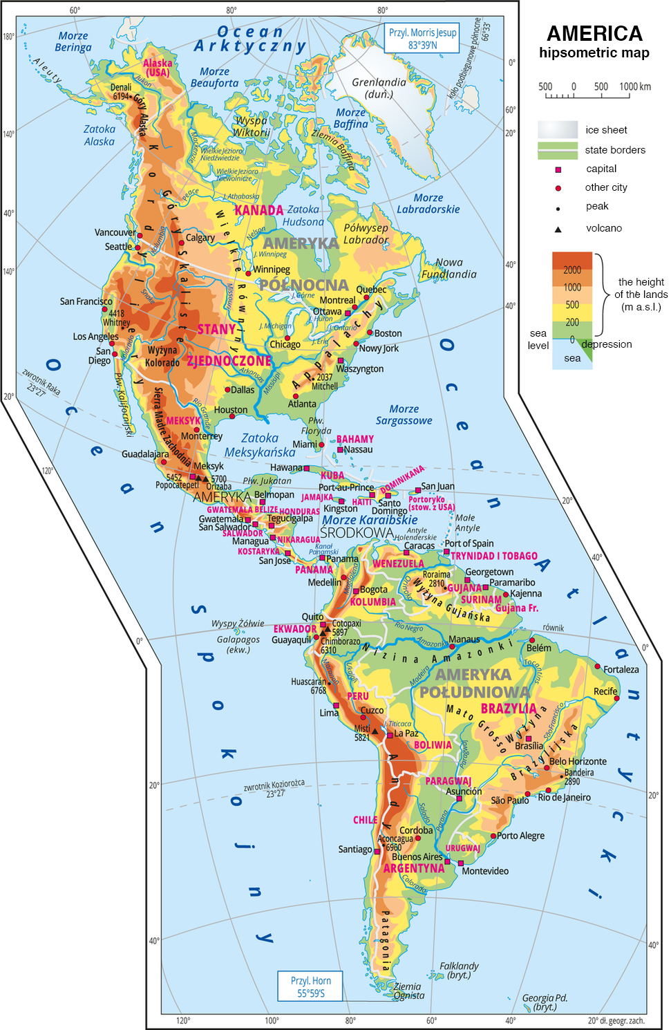
Ilustracja przedstawia mapę hipsometryczną Ameryki Północnej oraz Południowej, America hipsometric map. W obrębie lądów oznaczono wysokości nizin, wyżyn i gór. Na zachodnich wybrzeżach dominują pasma górskie o przebiegu południkowym. Rozległe niziny wzdłuż największych rzek. Na mapie opisano nazwy półwyspów, np. Półwysep Kalifornijski, Półwysep Labrador, wysp – np. Bahamy, Jamajka, Kuba, nizin – np. Nizina Amazonki, wyżyn np. Wyżyna Gujańska, Wyżyna Kolorado, Wyżyna Brazylijska, i pasm górskich – np. Andy, Kordyliery, Góry Skaliste, mórz – Morze Baffina, Morze Beauforta, zatok, np. Zatoka Alaska, Meksykańska, rzek – Missisipi, Missouri, Amazonka i jezior – Michigan, Ontario. Oznaczono i opisano stolice np. Ottawa, Waszyngton, Caracas i główne miasta, np. Nowy Jork, Vancouver, Manaus. Opisano nazwy państw, np. Kanada, Ekwador, Brazylia i czynne wulkany, np. Chimborazo, Cotopaxi. Podano współrzędne geograficzne skrajnych punktów: północ – Przylądek Morris Jesup, 83°39’N, południe – Przylądek Horn, 55°59’S. Zachodnie wybrzeża Ameryki otacza Ocean Spokojny, wschodnie wybrzeża Ocean Atlantycki. Najwyższe tereny znajdują się na zachodnich wybrzeżach kontynentów. W Ameryce Północnej: Sierra Madre Zachodnia, Wyżyna Kolorado, Góry Skaliste, Góry Alaska. W Ameryce Południowej to pasmo górskie Andy.
America’s hypsometric tints map
Source: Wydawnictwo Edukacyjne Wiking, licencja: CC BY 3.0.
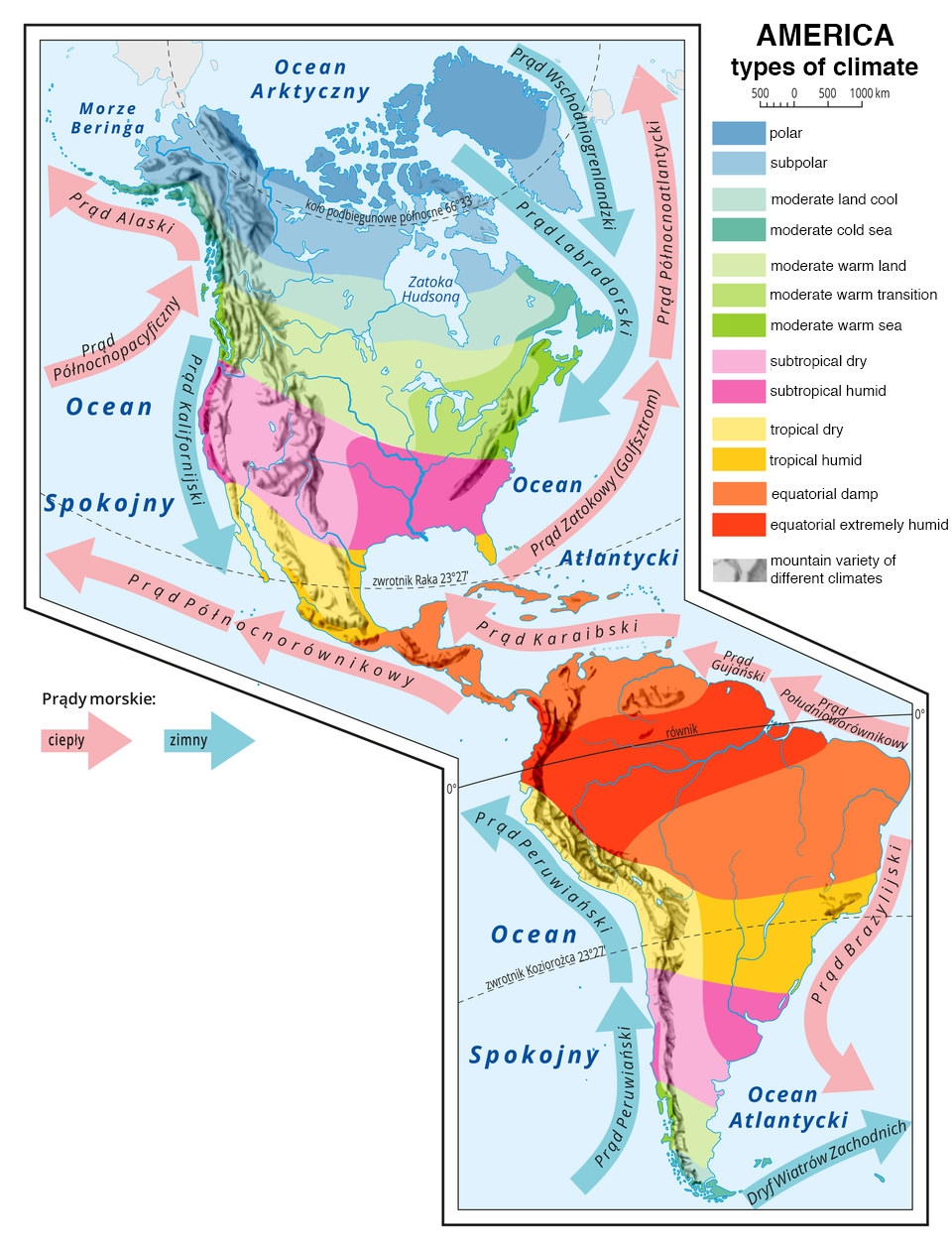
In North America climate is influenced by an extremely well‑developed coastline with two big bays – Hudson Bay filled with cold water in the north, and the Gulf of Mexico with warm water in the south.
In South America climate is strongly influenced by the situation of the major part of the land in the tropics and huge Amazon Basin covered with tropical rainforest.
R1IOntLJEtD5c
Ilustracja przedstawia mapę typów klimatu w Ameryce, America types of climate. Układają się one pasami o przebiegu równoleżnikowym. Wzdłuż równika klimat równikowy wybitnie wilgotny, equatorial damp i podrównikowy wilgotny, equatorial extremely humid. Na zwrotnikach klimat zwrotnikowy suchy, tropical damp i zwrotnikowy wilgotny, tropical humid. Na północ od zwrotnika Raka i na południe od zwrotnika Koziorożca klimat podzwrotnikowy suchy, subtropical damp i podzwrotnikowy wilgotny, subtropical humid. Dalej strefa klimatów umiarkowanych (lądowe i morskie, ciepłe i chłodne oraz przejściowy). Na północy klimat polarny, polar i subpolarny, subpolar. Wzdłuż wybrzeży kontynentu strzałkami przedstawiono prądy morskie. Ciepłe płyną od równika na północ: Prąd Południoworównikowy, Prąd Gujański, Prąd Karaibski, Prąd Zatokowy, Prąd Północnoatlantycki, Prąd Północnorównikowy, Prąd Północnopacyficzny, Prąd Alaski. Na południe płynie ciepły Prąd Brazylijski. Prądy zimne płyną z północy i południa ku równikowi. Są to Prąd Kalifornijski, Prąd Peruwiański, Prąd Labradorski, Prąd Wschodniogrenlandzki, Dryf Wiatrów Zachodnich.
America – types of climate
Source: Wydawnictwo Edukacyjne Wiking, licencja: CC BY 3.0, [online], dostępny w internecie: http://creativecommons.org/licenses/by/3.0/pl/legalcode.
The shape and climate have a significant impact on the water network of America. The Atlantic Ocean has the largest basin, because the main water section runs along the ridges of the North America Cordillera and the Andes. On both continents, the river network is distinguished by long rivers and a large surface of the river basins. In addition, in North America there are numerous lakes that were formed after the last glaciation (just as in Europe). The largest river system in North America consists of Mississippi and Missouri. Mississippi is 3658 km long, and together with Missouriit counts 5969 km. In the central eastern part of the continent there is a group of five Great Lakes which form the largest freshwater reservoir on Earth with an area of 250 thousand km Indeks górny 22 . The largest is Lake Superior with an area of 82.1 thousand km Indeks górny 22. The big rivers in South America are: the Amazon, the Paraná River and the Orinoco River. The Amazon River basin is located in the equatorial humid climate zone. The powerful tributaries on the left and right form the largest basin in the world with an area of 7 million km Indeks górny 22 . The Amazon is the river with the largest water resources on Earth – the average annual flow at the estuary is 175 thousand m Indeks górny 33 / s, which is about 160 times greater than the flow of the Vistula. For years, there have been disputes as to which of the two, the Nile or the Amazon, is the longest river in the world. The most recent measurements indicate that it is the Amazon River, as its length is 6,992 km (the Nile is 6,853 km).
Task 1
Wysłuchaj nagrania abstraktu, ułóż do niego pytania i zadaj je koledze.
Wysłuchaj nagrania abstraktu, ułóż do niego pytania i zadaj je koledze.
Divide vertical landform of both Americas. List the examples of the biggest forms.
RjvOovPac4qy4
Przypomnij sobie tytuł abstraktu, wysłuchaj nagrania i spróbuj zaproponować własny temat dla dzisiejszej lekcji.
Przypomnij sobie tytuł abstraktu, wysłuchaj nagrania i spróbuj zaproponować własny temat dla dzisiejszej lekcji.
RZ7ZE5IMfBNTb
Exercise 1
These names form the vertical landscape of North and South America. Indicate mountains, highlands and plains. Brazilian the Andes The North American Cordillera Gulf Coastal The Appalachian The Coast Orinoco The Guiana the Rockies the Amazon Cascades Patagonian la Plata.
These names form the vertical landscape of North and South America. Indicate mountains, highlands and plains. Brazilian the Andes The North American Cordillera Gulf Coastal The Appalachian The Coast Orinoco The Guiana the Rockies the Amazon Cascades Patagonian la Plata.
These names form the vertical landscape of North and South America. Mark mountains in red, highlands in yellow and plains in green.
red
yellow
green
Brazilian the Andes
The North American Cordillera Gulf Coastal The Appalachian
The Coast Orinoco The Guiana
the Rockies the Amazon Cascades
Patagonian la Plata
RcX2l9dmVULFG
Exercise 2
Put in the correct order climate types in North America starting from the northern region of the continent. Elementy do uszeregowania: 1. warm temperate continental, 2. cold temperate continental, 3. subpolar, 4. subtropical, 5. tropical, 6. polar
Put in the correct order climate types in North America starting from the northern region of the continent. Elementy do uszeregowania: 1. warm temperate continental, 2. cold temperate continental, 3. subpolar, 4. subtropical, 5. tropical, 6. polar
Put in the correct order climate types in North America starting from the northern region of the continent.
subpolar
cold temperate continental
tropical
polar
warm temperate continental
subtropical
RYz3AJMRwHlwF
Exercise 3
Point out three great rivers of South America. Możliwe odpowiedzi: 1. Amazon, 2. Parana, 3. Orinoko, 4. Pilcomayo, 5. Maroni
Point out three great rivers of South America. Możliwe odpowiedzi: 1. Amazon, 2. Parana, 3. Orinoko, 4. Pilcomayo, 5. Maroni
Point out three great rivers of South America
Amazon
Parana
Orinoko
Pilcomayo
Maroni
1
Keywords
America, climate types, North America, South America
cyrkulacja powietrza - system prądów powietrznych nad powierzchnią kuli ziemskiej. Przyczyną krążenia, czyli cyrkulacji powietrza w troposferze, są różnice w ogrzewaniu powierzchni Ziemi uzależnione od stref oświetlenia Ziemi.