Africa – forms of agriculture in the Sahel region
that there are desert and semi‑desert areas on Earth, which are characterised by water scarcity;
that water is one of the most universal substances in the world;
that water is vital for life on Earth;
that general and thematic maps can be used to describe the features of natural environment and economy of a specific area.
to describe the geographical location of the Sahel within Africa;
to describe the natural features of the Sahel using thematic maps;
to explain the importance of water for agriculture in semi‑arid areas;
about some of the negative effects of agriculture on the natural environment of the Sahel region.
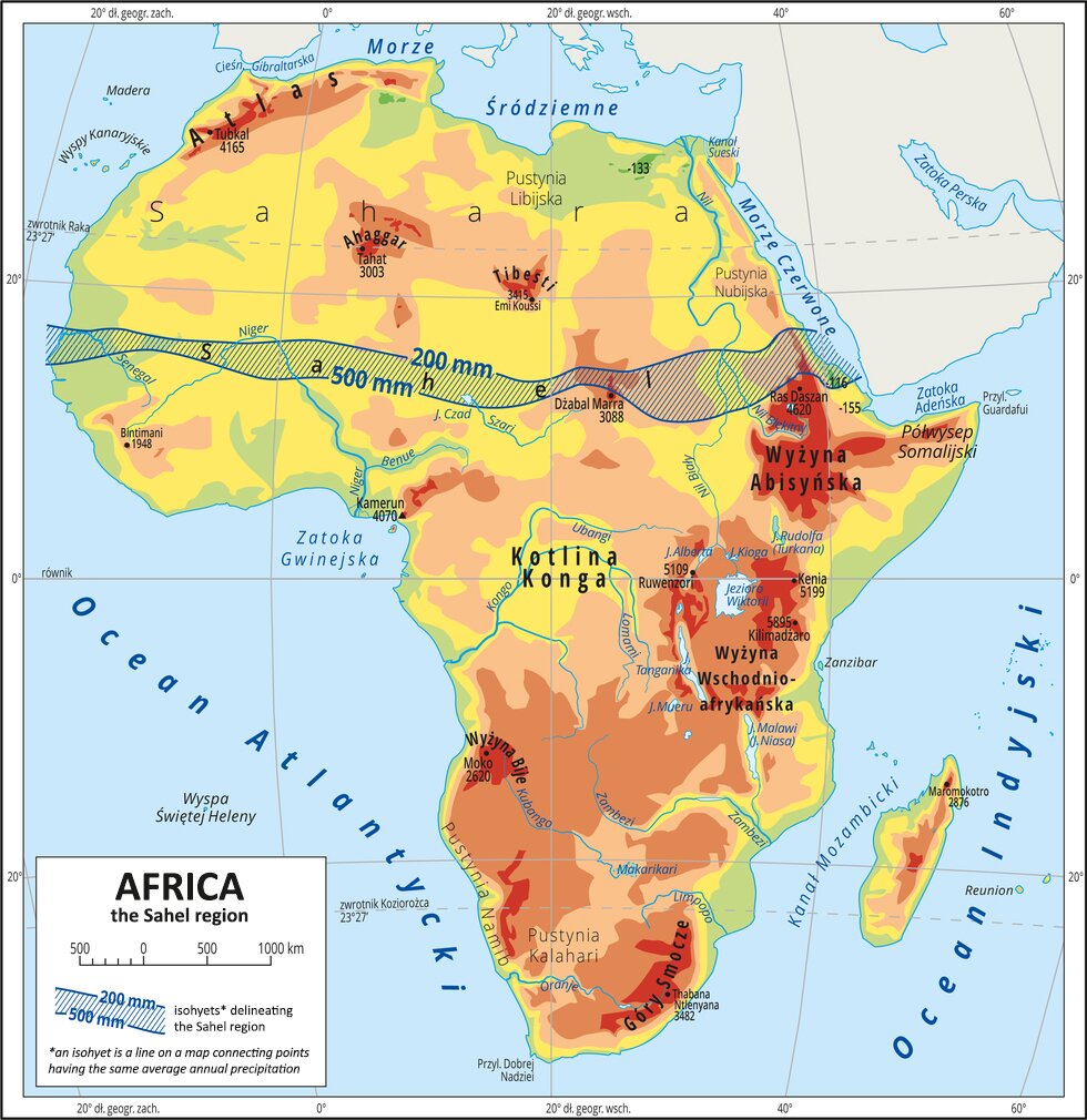
The Sahel – geographical location and natural features
South of the Sahara, there is a latitudinal belt of land, neither a desert, nor a typical savannah. Total annual precipitation in this area is between 200 and 500 mm, which, combined with very high air temperatures all year round, makes it possible only for various species of grasses, bushy shrubs and occasional trees to grow here. This temperate narrow strip of land stretching across Africa from the Atlantic Ocean in the west to the Ethiopian Highlands in the east is known as the Sahel. The term Sahel is derived from the Arabic language, in which it means 'shore, edge, borderland'. This name was first used to describe the semi‑arid region lying to the south of the Sahara in 1900. The Sahel is demarcated according to two annual isohyets (lines connecting points of equal total rainfall): 200 mm in the north and 500 mm in the south.
Below you can find a map showing the location of the Sahel region.
List the characteristic features of the geographic location of the Sahel region in the fields below.

We will use the climate diagram for the Abéché station to describe the climate of the Sahel region.
")
The climate of the Sahel region is characterised by very high average yearly air temperature of 25°C to 30°C. Seasons in the Sahel are marked by rainfall. The rainy season is short, lasting only 2 or 3 months. The remaining part of the year is the hot dry season. The irregularity of rainfall is a characteristic feature of the Sahel’s climate. The amount of precipitation varies from year to year as well as across months within one year. Sometimes, there several years of relatively heavier rainfall are followed by a period of no rain at all. Another important characteristic of the local climate is the fact that in the dry season temperatures can drop by about 10°C at night. These aspects of the Sahel’s climate have impact on other elements of its natural environment, as they:
shape the river network, affecting the discharge volume of rivers;
hinder plant growth;
affect the soils and fauna of the region.
Most rivers in the Sahel are ephemeral watercourses. This means that they fill with water when the rain comes, but disappear in the dry season, leaving only a dry valley behind. The only perennial rivers in the region are those that have their sources in areas characterised by a more humid climate. These are the Senegal River and the Niger River in the west and the middle section of the largest river of Africa – the Nile – in the east. Another important body of water in the Sahel is the ephemeral Lake Chad, located in the central part of the region. Its size varies from 26 thousand km² in the rainy season to just 7 thousand km² in the dry season. Large evaporation causes the surface area of Lake Chad to shrink and salt to precipitate from the water. These salt deposits are often extracted. All over the Sahel, there are many salty lakes and marshes that become alive with the coming of the rainy season.
The growth of vegetation in the Sahel is completely dependent on the distribution of rainfall across the year. Even though the Sahel is a very narrow strip of land, it has different vegetation in the north and in the south. In the north there are no trees at all, only patches of perennial grasses. In the south, however, vegetation forms a thick cover, with some acacia trees and gallery forests in dry beds of ephemeral rivers. The fauna of the region has adapted to the long dry season in various ways. Typical ungulates found in the Sahel, such as addax and oryx antelopes, are perfectly adapted to long periods of water scarcity. For example, as long as the grass is green, oryxes can survive up to a month without drinking. Other major groups of animals of the Sahel are rodents, such as gerbils or jerboas, as well as snakes, lizards and birds. Some rodent species store food in their burrows to get through a drought, or even hibernate through the dry season.
The effects of agriculture in the Sahel on its water resources
The Sahel is a dry region with low annual precipitation and high direct evaporation and plant transpiration. Lands in the Sahel are used for agriculture, but its ecosystem is extremely fragile and vulnerable to changes. Traditional animal herding according to the rhythm of rainfall and vegetation cycles are not what they used to be anymore. The population of the Sahel is constantly growing. Some social changes have come about as well.
The most primary factor that leads to the deterioration of wild pastures is irresponsible livestock herding, or overgrazing.
One of the key ways to improve the quality of life in the Sahel is to realise the full potential of the experiences, habits, traditions and customs of the local population. For many years now, attempts have been made to increase the reserves of water in semi‑arid areas. These efforts included digging high‑capacity deep wells. One of the primary objectives was to convince the nomads to take up a more sedentary lifestyle. However, during a dry spell too many animals would gather around such a well and feed on the surrounding vegetation until there was none left. In some cases they would even die of starvation despite water being readily available.
Work in groups. Every group will brainstorm one topic.
Use what you’ve learnt during the lesson and the available sources of information to complete the exercises below.
The poorest country of the Sahel – and the world – is:
- Mali
- South Sudan
- Chad
- Burkina Faso
Name the process causing the phenomenon shown in the photo.
This process starts with destruction of natural vegetation. During a dry spell, herds of animals do not follow their usual routes but rather go wherever there’s still food left. Overgrazing occurs, ground gets tamped down and soil erodes. Destruction of plant roots leaves soil exposed to blowing away with the wind.
This process is known as ..............................

The religion followed by most inhabitants of the Sahel countries is:
- Islam
- Judaism
- Hinduism
- Buddhism
When you uncover the image, you will see which areas in the Sahel (rural or urban) are inhabited by a majority of the local population (even up to 81%).
Name the capitals of the Sahel countries.
| Senegal | Dakar |
| Mali | Bamako |
| Somalia | Mogadishu |
| Mauritania | Nouakchott |
| Niger | Niamey |
| Chad | N’Djamena |
| Sudan | Khartoum |
| Eritrea | Asmara |
| Burkina Faso | Ouagadougou |
Keywords
Sahel region, nomadism, nomads
Glossary
nomadzi, koczownicy - grupa ludzi nieposiadającej stałego miejsca zamieszkania, przemieszczającej się z miejsca na miejsce, np. w związku ze zmianami pogody lub w poszukiwaniu żywności, wody, opału albo pastwisk dla zwierząt hodowlanych.
nomad, koczownik - członek pasterskiego lub ludu prowadzącego koczowniczy tryb życia, głównie w Afryce.