E-resource INLAND WATERWAY TRANSPORT
INLAND WATERWAYS
1. Film in the standard version.
Film dostępny na portalu epodreczniki.pl
In the film you will see a conversation between a ship captain and an apprentice sailor. The subject of the conversation are inland waterways. Film przedstawia rozmowę kapitana statku z marynarzem - praktykantem. Tematem rozmowy są śródlądowe drogi wodne.
2. Film with subtitles.

Film dostępny na portalu epodreczniki.pl
In the film you will see a conversation between a ship captain and an apprentice sailor. The subject of the conversation are inland waterways. Film przedstawia rozmowę kapitana statku z marynarzem - praktykantem. Tematem rozmowy są śródlądowe drogi wodne.
3. Film with subtitles and pauses. Listen and repeat after the speaker.

Film dostępny na portalu epodreczniki.pl
In the film you will see a conversation between a ship captain and an apprentice sailor. The subject of the conversation are inland waterways. Film przedstawia rozmowę kapitana statku z marynarzem - praktykantem. Tematem rozmowy są śródlądowe drogi wodne.
4. Film with subtitles and narration.

Film dostępny na portalu epodreczniki.pl
In the film you will see a conversation between a ship captain and an apprentice sailor. The subject of the conversation are inland waterways. Film przedstawia rozmowę kapitana statku z marynarzem - praktykantem. Tematem rozmowy są śródlądowe drogi wodne.
After watching the film “Inland waterways”, decide which of the following sentences are true, and which are false.
Po obejrzeniu filmu „Śródlądowe drogi wodne”, zdecyduj czy poniższe zdania są prawdziwe, czy fałszywe.
| Prawda | Fałsz | |
| The sailor is about to begin her practice on a motor barge. | □ | □ |
| The sailor is a bit nervous, because it's her first practice. | □ | □ |
| The sailor hasn't navigated any waterways before. | □ | □ |
| The classification of inland waterways is defined by a regulation. | □ | □ |
| The Vistula-Oder waterway belongs to the lowest waterway class. | □ | □ |
| The waterway connecting the Baltic Sea and the Black Sea is a waterway of regional importance. | □ | □ |
| The captain thinks the conversation was a good start. | □ | □ |
| The captain thinks they have discussed all of the important topics and the conversation is over. | □ | □ |
Exercises
After watching the film “Inland waterways”, fill in the gaps in the sentences. Use the word bank.
Po obejrzeniu filmu „Śródlądowe drogi wodne”, uzupełnij zdania odpowiednimi słowami. Skorzystaj z banku słów.
push convoys, cargo ship, training vessel, river mile, locks, flows, height under bridges, draught
The sailor has navigated a ........................................ so far.
The sailor is glad to be on a .........................................
Polish inland waterways are classified according to the size of ships or ........................................ approved for transport.
The minimum ........................................ is also important for the classification.
The ........................................ of II class waterways should be 1.8 m.
The ........................................ of II class waterways should be 57 m in length and 9.6 m in width.
The ........................................ of the Vistula-Oder waterway begins at zero and increases westward.
The Noteć river ........................................ into the Warta river.
After watching the film “Inland waterways”, match the Polish words/phrases with their translations.
Po obejrzeniu filmu „Śródlądowe drogi wodne”, połącz polskie terminy z ich tłumaczeniami.
classification, operational parameter, barrage, motor barge, waterway, draught, inland, lock, cargo ship, push convoy
| barka motorowa | |
| statek transportowy | |
| droga wodna | |
| śródlądowy | |
| klasyfikacja | |
| zestaw pchany | |
| parametr eksploatacyjny | |
| głębokość tranzytowa | |
| stopień wodny | |
| śluza |
THE WROCŁAW‑GDAŃSK WATERWAY CONNECTION

Film dostępny na portalu epodreczniki.pl
The animation illustrates the inland waterways across which a ship has to sail to travel from Wrocław to Gdańsk along with their navigation features and the total distance. Animacja przedstawia śródlądowe drogi wodne, którymi popłynie statek z Wrocławia do Gdańska, ich charakterystykę nawigacyjną oraz długość trasy.
After watching the animation “The Wrocław-Gdańsk Waterway Connection”, fill in the gaps in the sentences. Use the word bank.
Po obejrzeniu animacji z lektorem „Połączenie wodne Wrocławie z Gdańskiem”, uzupełnij luki w zdaniach. Skorzystaj z banku słów.
three stretches, inland waterways, canalised, Oder Waterway, Vistula-Oder Waterway, operational parameters, border, free flowing
When planning a cruise from Wrocław to Gdańsk, we use a map of Polish .............................................
The ............................................ connects Wrocław and Kostrzyn.
The ............................................ includes the Brda river, the Bydgoszcz Canal, the Noteć river and the Warta river.
The Oder Waterway consists of .............................................
............................................ Oder starts in Kędzierzyn Koźle and ends in Brzeg Dolny.
............................................ Oder stretches from Brzeg Dolny to the mouth of the Nysa Łużycka river.
............................................ Oder connects the mouth of the Nysa Łużycka river and the mouth of the Warta river.
The Oder is a river with the ............................................ of the II class.
Exercises
On the basis of the animation “The Wrocław-Gdańsk Waterway Connection”, match the Polish words/phrases with their translations.
Na podstawie animacji z lektorem „Połączenie wodne Wrocławia z Gdańskiem”, połącz polskie terminy z ich tłumaczeniami.
moor, draught, west side, east side, river mile, average water, waterway connection, the mouth of the river
| strona wschodnia | |
| strona zachodnia | |
| ujście | |
| głębokość tranzytowa | |
| średnia woda | |
| kilometraż | |
| cumować | |
| połączenie wodne |
Navigation and communication
The hypertext illustrates a conversation between a captain and a helmsman during the preparation to enter a lock. The captain uses a two way radio and gives instructions to a sailor.
Hipertekst przedstawia rozmowę kapitana ze sternikiem podczas przygotowania statku do wprowadzenia do śluzy. Kapitan kontaktuje się także przez radiotelefon ze śluzą oraz wydaje polecenia marynarzowi.
Captain: Helmsman, we are now in conditions of limited visibilitylimited visibility. Keep the course in line with radar indicationsradar indications.
Helmsman: Reach set at 500 m. We're approaching the bridge.
Captain: Make the course goodMake the course goodon the centre of the navigable span.
Helmsman: I'm keeping the course. Distance 200 m.
Captain: I'm increasing the speedincreasing the speed to 1600 rotations. Helmsman, strike the maststrike the mast, lower the wheelhouselower the wheelhouse.
Helmsman: Mast struck, wheelhouse lowered.
Captain: „This is Bizon 115, I'm at the 617 km, I'm approaching the road bridge. When I pass the bridge, I'm going to enter the locklock in Berent”.
Helmsman: We've passed the bridge. I can see the lock echo. Bearing 067, distance 1.5 km.
Captain: Set the course towards the lock. Speed down to 10 km. Channel VHF 74.
Helmsman: I'm keeping the course in line with radar indications.
Captain: Helmsman, keep the course towards the white flashing light. „Lock in Berent, this is Bizon 115”.
Berent lock: Berent to Bizon 115.
Captain: Good evening, I've passed the bridge at 617, I'm moving upstream.
Berent lock: Good evening. What type of cargo, where to, where from?
Captain: Push convoyPush convoy Bizon 115, coal, 800 tons from Minden to Welwet.
Berent lock: Ship data, please?
Captain: Length 112 m, width 8.20 m, 1200 tons.
Berent lock: Good, right lock, second ship.
Captain: Very well. Thank you.
Helmsman: We're entering the outportoutport. Speed down to 4 km.
Captain: Access to lock granted. Keep the course on the centre of the lock.
Helmsman: Which board are we docking on, sir?
Captain: Dock on the starboardDock on the starboard**. **FendersFenders to starboard. Ready the lines.
Sailor: Fenders out, lines ready.
Captain: Pass the lines to the lock crew.
Sailor: Lines passed. We're going through the lock.
Captain: Helmsman, wind from port side.
Helmsman: I'm going upwind.
Captain: We're heading towards a branch. The main trail goes right.
Helmsman: We're going to the left. We're leaving the main trailmain trail.
Captain: To all ships, this is Bizon 115, I'm at the 585 km. I'm leaving the main trail. I'm heading towards the Canal to Welwet.
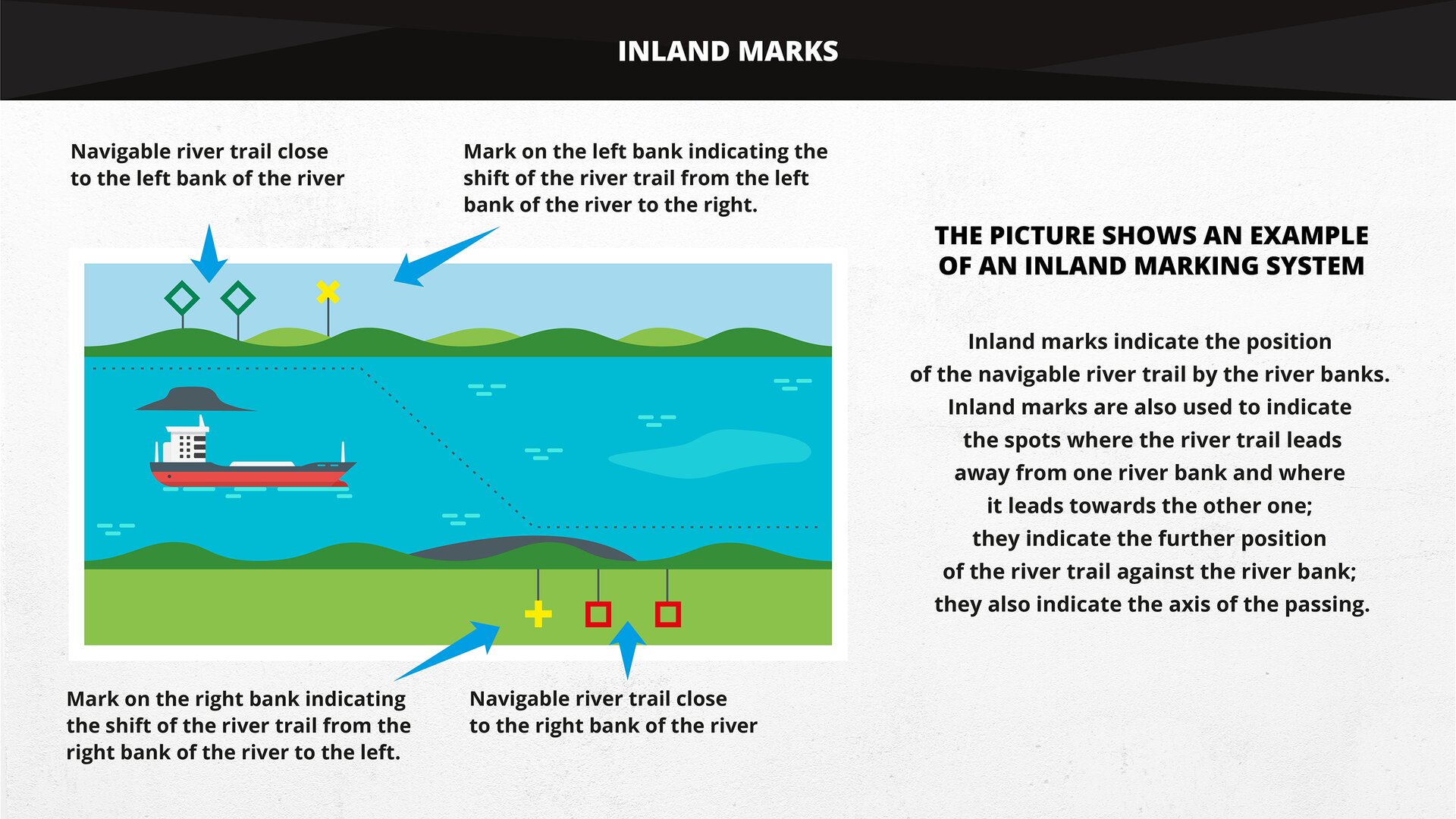
WATERWAY MARKING SYSTEM

Film dostępny na portalu epodreczniki.pl
The conversation is between a captain and a helmsman. The topic of the conversation concerns the waterway marking system. Rozmowa toczy się pomiędzy kapitanem i sternikiem. Dialog dotyczy oznakowania szlaku żeglownego.
After listening to the audio recording “Waterway marking system”, choose the correct answer.
Po wysłuchaniu nagrania audio „Oznakowanie szlaku wodnego”, wybierz prawidłową odpowiedź.
a telescope, decrease, right, stay the same, lateral, triangle, main, increase, closed, left, is in an equal distance to, north, opened, buoys, damaged, stones, centre of the canal, leads away from, square, binoculars, leads towards, groynes, oblong, glasses
The captain informs the helmsman that the main trail has been .................................................... for navigation.
The captain decides to sail down the .................................................... canal.
The helmsman should keep to the .....................................................
The captain notices that the navigation trail .................................................... the right bank.
The captain draws the helmsman's attention to .................................................... pushed far into the river bed.
The helmsman notices a navigation mark on the left bank – it's a green .................................................... pointing up.
A navigational warning is issued, motor barge BM 5234 has lost its anchor. The helmsman is told to watch for the mark through .....................................................
The helmsman thinks that the wind speed is going to .....................................................
Exercises
After listening to the audio recording “Waterway marking system”, decide which sentences are true, and which are false.
Po wysłuchaniu nagrania audio „Oznakowanie szlaku wodnego”, zdecyduj które wypowiedzi są prawdziwe, a które fałszywe.
| Prawda | Fałsz | |
| The helmsman is passing the shoal on the eastern side. | □ | □ |
| The helmsman informs the captain that the strong current is pushing them towards the right breakwater and they have been driven off course. | □ | □ |
| When the ship is in the lagoon, it is no longer in the vessel traffic service. | □ | □ |
| When the ship is in the lagoon, it enters the river trail. | □ | □ |
| The racon data is different from the information on the map. | □ | □ |
| The captain tells the helmsman that they have to determine the ship's position. | □ | □ |
| The helmsman doesn't know how to determine the ship's position. | □ | □ |
| The helmsman informs the captain that there is no water margin under the keel. | □ | □ |
OPERATIONAL PARAMETERS OF INLAND WATERWAYS

Gallery


CROSSWORD AND TYPOS

Zasób interaktywny dostępny pod adresem https://zpe.gov.pl/a/D1CfESSmv

Zasób interaktywny dostępny pod adresem https://zpe.gov.pl/a/D1CfESSmv
Dictionary
kotwica
średnia woda
oś
oś toru wodnego
brzeg
stopień wodny
lornetka
dno statku
falochron
pława ze znakiem szczytowym
pława walcowa
kanał
znak kardynalny
statek transportowy
klasyfikacja
closed for navigation
pława stożkowa
promień łuku
miejsce niebezpieczne
różnica poziomów
cumować prawą burtą
głębokość tranzytowa
strona wschodnia
wejście do portu
ujście
odbijacz
znak pływający
śluza
swobodnie płynąca
pełne zanurzenie
ostroga
najwyższa woda żeglowna
zwiększać prędkość
znak informacyjny
śródlądowy
znak brzegowy
śródlądowa droga wodna
stępka
trzymać kurs
brama torowa
oddalać się
przybliżać się
nabieżnik
ograniczona widzialność
obniżać sterówkę
główny tor
znak nakazu
dopuszczalna ładowność
minimalny prześwit pod mostem
barka motorowa
szlak żeglowny
znak nawigacyjny
ostrzeżenie nawigacyjne
parametr eksploatacyjny
awanport
tyka ze znakiem szczytowym
położenie
znak zakazu
zestaw pchany
wskazanie radaru
reflektor radarowy
światło rytmiczne
koryto rzeki
tor wodny
rzeka
światło sektorowe
pozycja statku
mielizna
stacja odezwowa
kłaść maszt
Odrzańska Droga Wodna
droga wodna
strona zachodnia