What is the Earth’s rotation? What are the consequences of the Earth’s rotation?
What is the Earth’s rotation? What are the consequences of the Earth’s rotation?
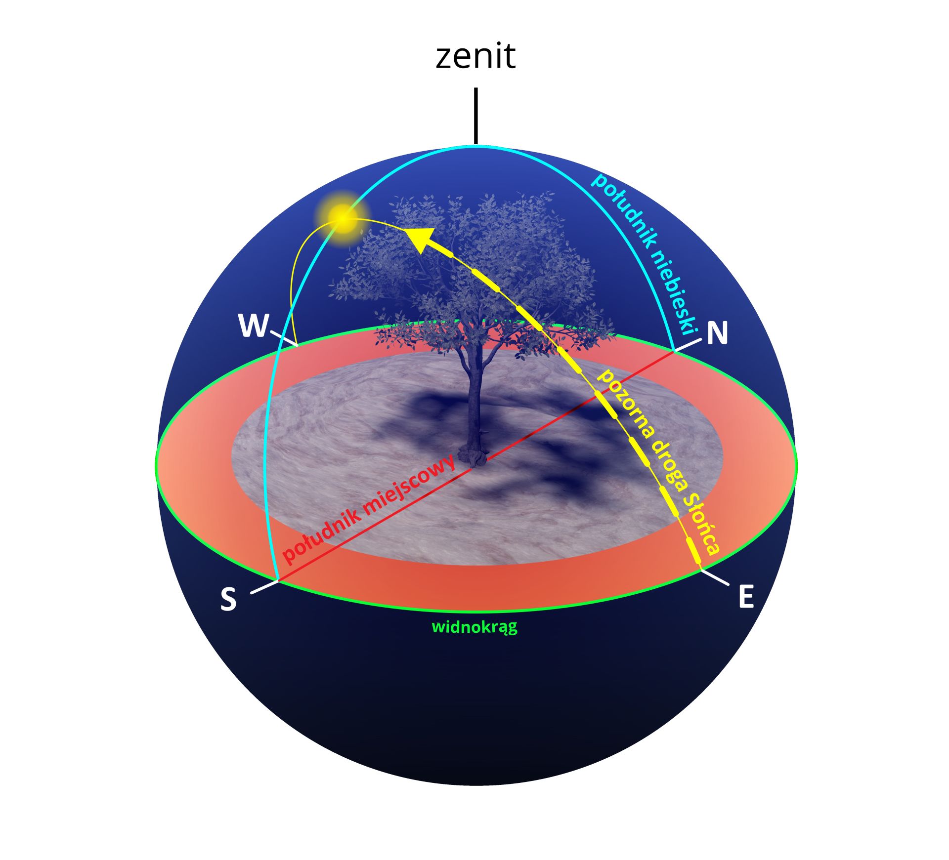
Solar time
Solar noon is simultaneously recorded for the entire area located on the same meridian. The Sun is at its highest point simultaneously on the whole meridian, but at different heights in relation to the horizon. However, it is always the highest position of the Sun in a given place during the day. Of course, wherever there is a polar night, the Sun is invisible even at midday because it is below the horizon line also at the time when the Sun reaches its highest point. If an observer (located at any point on the globe) marked in the celestial sphere the place where the Sun is at its highest and connected it, in an arc, in the shortest way possible, with the point on the horizon that determines the south (S), and extended the opposite side to the zenith and further to the point on the horizon defining the north (N), this would be the line called the celestial meridiancelestial meridiancelestial meridian. Projection of the celestial meridian onto the surface of the Earth corresponds to the local meridian.
R1Gf2fBp6bmh5
Ilustracja interaktywna przedstawia zmiany oświetlenia Ziemi w ciągu doby. Grafika pokazuje sferę, pośrodku niej znajduje się drzewo, a poszczególne punkty przedstawiają konkretne elementy.
Numer 1 przedstawia zenit Zenith - najwyższy punkt sfery niebieskiej. Każde miejsce na Ziemi ma swój zenit w innym punkcie sfery niebieskiej.
Numer 2 przedstawia południk niebieski celestial meridian -koło wielkie przechodzące przez zenit i bieguny niebieskie. W czasie obrotu sfery niebieskiej wszystkie ciała niebieskie przechodząc przez południk osiągają najwyższe i najniższe położenie w stosunku do horyzontu (tzn. górują lub dołują).
Numer 3 przedstawia pozorną drogę słońca apparent path of the Sun. Słońce wychodzi zza horyzontu (ze wschodu) i posuwa się w górę, a potem zaczyna opadać i zachodzi za druga stronę horyzontu (zachód). Sprawia wrażenie jakby wokół ziemi była elipsa, która jest drogą ruchu słońca. Numer 4 przedstawia południk miejscowy local meridian. To średnica koła wierzchołkowe, przechodzącego przez bieguny niebieskie. Jego przecięcie z kołem horyzontu wyznacza na nim punkt południa i punkt północy. Numer 5 przedstawia widnokrąg horizon - granicę widoczności w płaszczyźnie horyzontu, linię pozornego zetknięcia nieboskłonu z powierzchnią Ziemi. W terenie otwartym widnokrąg jest zbliżony kształtem do okręgu.
1
2
3
4
5
1. zenith
2. celestial meridian
3. apparent path of the Sun
4. local meridian
5. horizon
It has been decided that the Sun’s highest point, on any meridian, is the middle of the day, which started 12 hours earlier in the same place, i.e., at midnight. The Sun’s highest point is the basis for determining solar time. It has been assumed that at noon it is 12:00 o’clock, and the whole day is divided into 24 hours. For Earth, we describe longitudes from 0° to 180° east and from 0° to 180° west, which combined comes to 360°. With this in mind, it is easy to calculate (by dividing 360° into 24 hours) that every 15° of longitude correspond to a time difference of one hour, and that 1° of longitude corresponds to a time difference of 4 minutes. For example, if we assume that the time on the 0° meridian is noon, i.e., 12:00 local solar time, then the time on the 15°W meridian will be one hour earlier, i.e., 11:00, and on the 15°E meridian – one hour later, i.e., 13:00 solar time.
Zone time and universal time
At an international conference in Washington in 1884, representatives of most of the world’s economically developed countries agreed that the prime meridian for calculating longitude and time on Earth would be the 0° meridian, passing through the astronomical observatory in Greenwich. The solar time of this meridian was called universal timeuniversal timeuniversal time. It was also agreed that the Earth would be divided into 24time zonestime zonestime zones assigned to all hours of the day. Each zone has a time corresponding to the solar time of the zone’s central meridian, and extends 7°30' east and 7°30' west of the central meridian. The central meridians of the zones are the 0° meridian, the 180° meridian, and all others that are multiples of 15° on both hemispheres. A significant part of western and central Europe, including Poland, is situated in the zone of the 15°E meridian, which extends from the 7°30'E to the 22°30'E meridians. When it is 12:00 o’clock in the zone of the 0° meridian – called the Universal Time Zone or the Western European Time Zone – in our Central European Time Zone it is 13:00. In the Eastern European Time Zone (from 22°30'E to 37°30'E, central meridian: 30°E) it is 14:00. The more time zones you go east of the 0° meridian, the more hours you need to add, and the more time zones you go west of 0°, the more hours you need to subtract.
RsGAIsmszzYZl
Ilustracja interaktywna przedstawia mapę stref czasowych. Numer 1 to tytuł mapy- Strefy czasu rzeczywistego na lądzie. Real time zones on land. Numer 2 przedstawia legendę - umowne strefy czasowe na morzach Contractual time zones on the seas, międzynarodową linię dat International date line, granicę stref czasowych na lądzie Boundary of time zones on land. Głównym południkiem do obliczania długości i czasu na Ziemi jest południk 0 °, przechodzący przez obserwatorium astronomiczne w Greenwich. Mapa jest podzielona na 24 , 15 stopniowe, kolorowe strefy.
Znaczna część Europy Zachodniej i Środkowej, w tym Polska, znajduje się w strefie południka 15 ° E, która rozciąga się od meridianów siedem stopni i trzydzieści minut E do dwudziestu dwóch stopni i trzydziestu minut E. Kiedy jest godzina 12:00 w strefie południka zero stopni - nazywanej Universal Time Zone lub Western European Time Zone - w naszej środkowoeuropejskiej strefie czasowej jest 13:00. W strefie czasowej Europy Wschodniej (od dwudziestu dwóch stopni i trzydziestu minut E do trzydziestu siedmiu stopni i trzydziestu minut E, środkowy południk: trzydzieści stopni E) jest 14:00. Im więcej stref czasowych znajduje się na wschód od południka zero stopni, tym więcej godzin trzeba dodać, a im więcej stref czasowych znajduje się na zachód od zera stopni, tym więcej godzin trzeba odjąć.
Standard time and the International Date Line
Almost all of France, Belgium and the Netherlands are within the universal time zone, but, for practical reasons, they adopted the Central European Time as their standard timestandard timestandard time in order to avoid complications at the borders with neighboring countries. Spain lies even further west, reaching as far as the time zone of the 15°W meridian, and yet it made an official decision to move its entire territory to the zone of the Central European Time. Some countries also introduce seasonal (summer) time by means of official decisions. Throughout the European Union, and therefore also in Poland, it applies from the last Sunday of March to the last Sunday of October, i.e., for approximately seven months.
Because of granting the status of Universal Time to the 0° meridian and its time zone, the 180° meridian had to be considered as the International Date LineInternational Date LineInternational Date Line. In some places, this line diverges from the 180° meridian because it crosses inhabited areas. The dates on its sides differ by one day. If you cross the International Date Line when traveling from the eastern hemisphere to the western hemisphere, you must subtract one day from the current date (valid on the western side of the line thus ‘gaining’ one day), and when moving in the opposite direction – from the western hemisphere to the eastern hemisphere – you must add one day to the date (valid on the eastern side of the line, thus ‘losing’ one day).
R13zoZCZAg6Sd
Ilustracja interaktywna przedstawia rzut kuli ziemskiej. Po lewej znajduje się półkula zachodnia, a po prawej półkula wschodnia. Na półkuli zachodniej zaznaczony jest Vancouver, a na półkuli wschodniej Tokyo. Kula ziemska podzielona jest na 24 strefy, co 15 stopni. Wokół kuli ziemskiej znajduje się okrąg podzielony na 24 części, wskazujący godziny. Punkt 1 oznacza linie zmiany daty. Punkt 2 oznacza samolot lecący z Tokyo do Vancouver The plane from Tokio to Vancouver gains one day, który zyskuje jeden dzień. Punkt 3 oznacza samolot lecący z Vancouver do Tokyo The plane from Vancouver to Tokio loses one day, który traci jeden dzień. Punkt 4 oznacza zachodnią hemisferę WESTERN HEMISPHERE, a punkt 5 oznacza wschodnią hemisferę EASTERN HEMISPHERE.
Ilustracja interaktywna przedstawia rzut kuli ziemskiej. Po lewej znajduje się półkula zachodnia, a po prawej półkula wschodnia. Na półkuli zachodniej zaznaczony jest Vancouver, a na półkuli wschodniej Tokyo. Kula ziemska podzielona jest na 24 strefy, co 15 stopni. Wokół kuli ziemskiej znajduje się okrąg podzielony na 24 części, wskazujący godziny. Punkt 1 oznacza linie zmiany daty. Punkt 2 oznacza samolot lecący z Tokyo do Vancouver The plane from Tokio to Vancouver gains one day, który zyskuje jeden dzień. Punkt 3 oznacza samolot lecący z Vancouver do Tokyo The plane from Vancouver to Tokio loses one day, który traci jeden dzień. Punkt 4 oznacza zachodnią hemisferę WESTERN HEMISPHERE, a punkt 5 oznacza wschodnią hemisferę EASTERN HEMISPHERE.
R1ZZtU6V2WO0p
Exercise 1
Which of the following phenomena is crucial for determining the solar time at a given location? Możliwe odpowiedzi: 1. the moment when the Sun appears above the horizon, 2. the moment when the Sun is at its highest point above the local meridian, 3. the moment when the Sun disappears under the horizon, 4. the moment when the Moon is at its highest point above the local meridian
Which of the following phenomena is crucial for determining the solar time at a given location? Możliwe odpowiedzi: 1. the moment when the Sun appears above the horizon, 2. the moment when the Sun is at its highest point above the local meridian, 3. the moment when the Sun disappears under the horizon, 4. the moment when the Moon is at its highest point above the local meridian
Which of the following phenomena is crucial for determining the solar time at a given location?
the moment when the Sun appears above the horizon
the moment when the Sun is at its highest point above the local meridian
the moment when the Sun disappears under the horizon
the moment when the Moon is at its highest point above the local meridian
Summary
Time zones were introduced in order to organize the readings of time on the entire globe.
In some countries, summer time is also adopted by means of an official decision.
Keywords
Earth’s rotation, summer time, winter time, International Date Line
czas uniwersalny – czas słoneczny na południku zerowym, za który przyjęto południk przechodzący przez obserwatorium astronomiczne Greenwich w Londynie; jest jednocześnie czasem strefowym pierwszej strefy czasowej, od której liczy się czas pozostałych stref
czas urzędowy – umowny czas obowiązujący na danym obszarze; czas urzędowy zwykle ustalany jest w taki sposób, aby cały obszar kraju lub jednostki administracyjnej znajdował się w tej samej strefie; w państwach o dużej rozciągłości równoleżnikowej na różnych obszarach może obowiązywać inny czas urzędowy; w wielu państwach czas urzędowy odpowiada czasowi strefowemu odpowiedniej strefy czasowej; są również kraje, w których urzędowo wprowadza się czas letni przesunięty o godzinę w stosunku do czasu strefowego
międzynarodowa linia zmiany daty – częściowo pokrywa się ona z południkiem 180°; czas obowiązujący na terytoriach położonych na zachód od tej linii (czyli na półkuli wschodniej) jest przesunięty o dobę do przodu względem czasu terytoriów położonych na wschód od niej (czyli na półkuli zachodniej)
południk niebieski – linia na sferze niebieskiej łącząca punkt na horyzoncie określający kierunek południowy (S) z punktem na horyzoncie określającym kierunek północny (N) i przechodząca przez zenit; południk niebieski jest miejscem, gdzie odbywają się górowania ciał niebieskich
strefa czasowa – obszary powierzchni Ziemi o szerokości 15° długości geograficznej, rozciągające się południkowo; w całej tak wyznaczonej strefie obowiązuje jednakowy czas; jednocześnie jest to czas słoneczny środkowego południka tej strefy