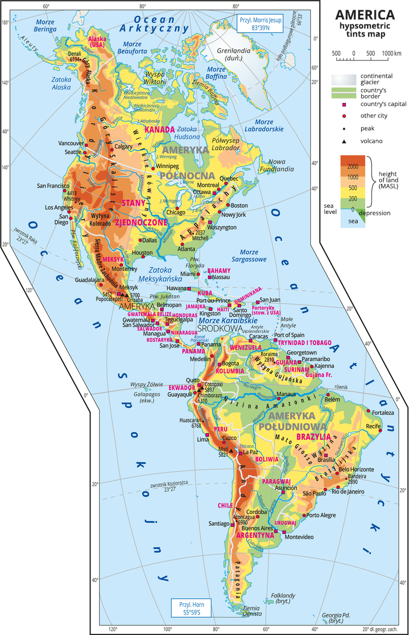
Ilustracja przedstawia mapę hipsometryczną Ameryki. Na zachodnich wybrzeżach dominują pasma górskie o przebiegu południkowym. Rozległe niziny występują wzdłuż największych rzek. W Ameryce Północnej są ti: Rio Grande, Missisipi. W Ameryce Południowej są to Amazonka, Rio Negro, Parana. Na mapie ukazane są wody opływające Ameryki. Od wschodu jest to Ocean Atlantycki, a od zachodu Ocean Spokojny. Nad Ameryka Północną jest Ocean Arktyczny. W Ameryce Północnej zaznaczono państwa: Kanada, Stany Zjednoczone i Meksyk. Z kolei największe państwa Ameryki Południowej to Argentyna, Boliwia, Brazylia, Chile, Ekwador, Gujana, Kolumbia, Paragwaj, Peru, Surinam, Urugwaj, Wenezuela, Trynidad i Tobago.Trójkątami oznaczono czynne wulkany i podano ich nazwy i wysokości. Podano współrzędne geograficzne skrajnych punktów: północ – Przylądek Morris Jesup, 83°39’N, południe – Przylądek Horn, 55°59’S.
America’s hypsometric tints map
Source: Wydawnictwo Edukacyjne Wiking, licencja: CC BY 3.0.
R1GIUHlE2SO2x
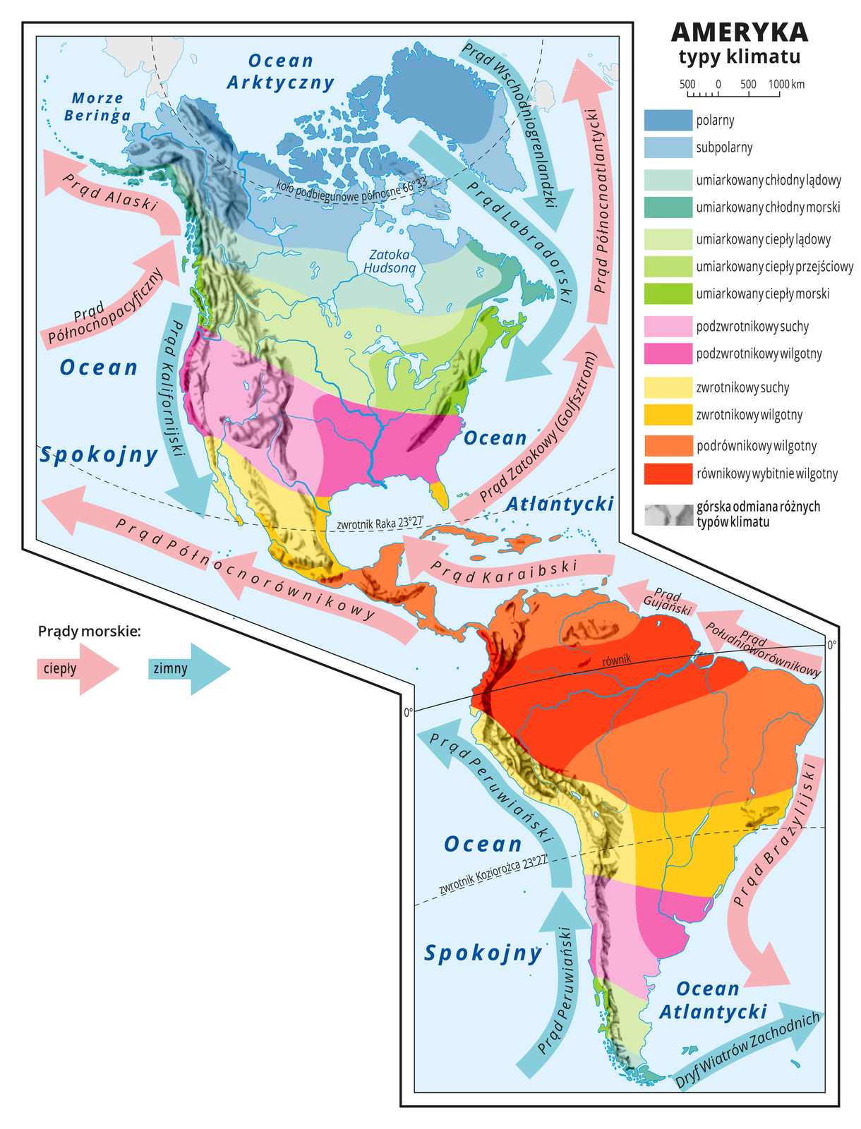
Ilustracja przedstawia mapę typów klimatu w Ameryce, układają się one pasami o przebiegu równoleżnikowym. Wzdłuż równika klimat równikowy wybitnie wilgotny i podrównikowy wilgotny. Na zwrotnikach klimat zwrotnikowy suchy i zwrotnikowy wilgotny. Na północ od zwrotnika Raka i na południe od zwrotnika Koziorożca klimat podzwrotnikowy suchy i podzwrotnikowy wilgotny. Dalej strefa klimatów umiarkowanych (lądowe i morskie, ciepłe i chłodne oraz przejściowy). Na północy klimat polarny i subpolarny. Wzdłuż wybrzeży kontynentu strzałkami przedstawiono prądy morskie. Ciepłe płyną od równika na północ i na południe, zimne płyną z północy i południa ku równikowi.
America – types of climate
Source: Wydawnictwo Edukacyjne Wiking, licencja: CC BY 3.0, [online], dostępny w internecie: http://creativecommons.org/licenses/by/3.0/pl/legalcode.
Two large landmasses lying in the Western Hemisphere are referred to by one name – America. The larger of the two, with the surface of 24.2 million km Indeks górny 22 , is located entirely in the Northern Hemisphere – it is North America, the third largest continent on Earth. A slightly smaller landmass with an area of 17.8 million km Indeks górny 22 crosses the Equator, and the major part of the continent lies in the Southern Hemisphere, which is why we call it South America. Both continents are connected by a land bridge with its narrowest point in the IsthmusIsthmusIsthmus of Panama - the width of 46 km. The second „bridge” consists of archipelagos of islands lying in the east of the Caribbean Sea. The biggest are the Great Antilles. For several centuries, they were called West India, because the first exploratory expeditions, who reached them, believed they were India. A continental bridge from the Isthmus of Tehuantepec to the Panama CanalPanama CanalPanama Canal and the island bridge are distinguished as Central America, which geographically belong to North America.
Task 1
Familiarize yourself with the information on the graphic.
RT0Fx8XgUGn9m
Ilustracja przedstawia kulę ziemską z widocznymi kontynentami - Ameryką Północną i Ameryką Południową. Po wybraniu jednego z ośmiu punktów zaznaczonych na ilustracji dostępny jest opis:
1. Gulf of Mexico
Bay in the western part of the Atlantic Ocean off the coast of North America. It lies between the Yucatan Peninsula and Florida, and it is closed off the open ocean and the Caribbean Sea by the island of Cuba.
2. Caribbean Sea
The sea is a part of the Atlantic Ocean's ocean system, located north of South America and east of Central America.
3. Florida peninsula
Peninsula in the south-eastern part of the USA, between the Gulf of Mexico and the Atlantic Ocean. The principal city is Miami. It is an important tourist region.
4. Baja California Peninsula
Peninsula in the north-west part of Mexico on the Pacific Ocean. It extends to 1200 km. It separates the Gulf of California from the Pacific.
5. Gulf of California
A large and narrow bay located in the Eastern Pacific. It extends along the north-west coast of Mexico. On the west it is closed by the mountainous Baja California Peninsula and on the east by the continental coast of Mexico.
6. Pacific Ocean
The largest, deepest and oldest water reservoir in the world. With an area of 155.6 million km, it occupies 30% of the entire Earth's surface.
7. Island of Cuba
An island in the Caribbean Sea in the archipelago of the Greater Antilles. The island, along with many smaller islands surrounding it, is the core of the territory of the state of Cuba.
8.Cape Horn
A rocky cape located on the Horn Island, in the archipelago of Tierra del Fuego. It is the southernmost point of South America.
Source: licencja: CC 0.
R1DxXxMnzd6XI
Exercise 1
Wysłuchaj nagrań słówek w słowniczku i naucz się ich prawidłowej wymowy.
Wysłuchaj nagrań słówek w słowniczku i naucz się ich prawidłowej wymowy.
Source: licencja: CC 0.
Exercise 2
RRDp7N7rJA8zk
Podaj nazwy dwóch łańcuchów górskich Ameryki Północnej.
Podaj nazwy dwóch łańcuchów górskich Ameryki Północnej.
Complete the names of geographic features included in the coastline of both Americas.
Labrador
Peninsula
Baja California
Peninsula
Cuba
Island
Yucatán
Peninsula
Panama
Canal
Baffin
Island
Caribbean
Sea
Mexico
Gulf of
California
Gulf of
Panama
Gulf of
Florida
Peninsula
Hudson
Bay
Beaufort
Sea
Bering
Strait
Drake
Passage
Keywords
America, North America, South America
R1VXoJrLHrYuW
Exercise 3
Match the pairs: English words with Polish definition. Isthmus Możliwe odpowiedzi: 1. wąski pas lądu łączący dwa większe obszary lądowe, oddzielający od siebie dwa morza lub oceany., 2. wąski pas lądu łączący dwa większe obszary lądowe, oddzielający od siebie dwa morza lub oceany. Panama canal Możliwe odpowiedzi: 1. wąski pas lądu łączący dwa większe obszary lądowe, oddzielający od siebie dwa morza lub oceany., 2. wąski pas lądu łączący dwa większe obszary lądowe, oddzielający od siebie dwa morza lub oceany.
Match the pairs: English words with Polish definition. Isthmus Możliwe odpowiedzi: 1. wąski pas lądu łączący dwa większe obszary lądowe, oddzielający od siebie dwa morza lub oceany., 2. wąski pas lądu łączący dwa większe obszary lądowe, oddzielający od siebie dwa morza lub oceany. Panama canal Możliwe odpowiedzi: 1. wąski pas lądu łączący dwa większe obszary lądowe, oddzielający od siebie dwa morza lub oceany., 2. wąski pas lądu łączący dwa większe obszary lądowe, oddzielający od siebie dwa morza lub oceany.
Match the pairs: English words with Polish definition.
wąski pas lądu łączący dwa większe obszary lądowe, oddzielający od siebie dwa morza lub oceany., wąski pas lądu łączący dwa większe obszary lądowe, oddzielający od siebie dwa morza lub oceany.
kanał Panamski - sztuczny kanał wodny położony w Panamie na Przesmyku Panamskim. Łączy wody Oceanu Atlantyckiego z wodami Oceanu Spokojnego. Długość kanału wynosi 81,6 km, szerokość 91,5‑305 m. Przesmyk- wąski pas lądu łączący dwa większe obszary lądowe, oddzielający od siebie dwa morza lub oceany.