Surface waters in Europe
that water continuously circulates in the natural environment;
that rivers are one of the land forming factors;
that river erosion wears away landforms, then, the material is carried, and subsequently, new landforms are being formed in the process of sedimentation;
that the river valley cross section is different in its upper course, middle course, and lower course;
that climate is one of the most important factors affecting river network in the relevant area.
to indicate, on a hypsometric map, major rivers and lakes of Europe;
to explain the variation of the water network in large regions of Europe;
to explain reasons for estuaries and deltas being formed by rivers;
to indicate examples of interconnections between the river regime, climate type and land morphology.
Waters are an exceptionally important component of the natural environment. Recall water circulation in nature. A part of this circulation comprises surface waters which rivers, lakes, swamps and glaciers belong to. This lesson presents variety of the river network and distribution of the Lakelands in Europe.
Draw a typical river, from source to mouth, indicating some tributaries.
River classification
A mass of water, flowing in a natural channel, driven by gravitation, is called a river. According to its length and size of the drainage basin, rivers belong to one of three categories: small, medium and large. According to its gradient which affects river’s velocity, rivers belong to one of three categories: mountain rivers, highland rivers and lowland rivers. All rivers, also called watercourseswatercourses, are supplied by rainwater and water coming from melting snow or glacier. These waters flow on the surface but also saturate the soil only to emerge again as sources. Watercourses are divided into permanent and periodical, with regard to their flow period.
The aforementioned classifications will serve to characterise the river networkriver network in Europe.
Components of natural environment shaping the river network in Europe
Disposition of the river network existing in a certain area depends on many components of the natural environment. Density of the river network is affected by: precipitation magnitude, type of rocks in the ground, land inclination and vegetation type. At the same time, flowing waters act on the other components of the natural environment. Using a map you can read that the highest total annual precipitation in Europe occurs in the mountains. These lands are inland areas for many rivers. Describing the river network of Europe, one must also indicate the catchment areascatchment areas where the rivers discharge their waters.
Characteristic of the river network in large physical and geographical regions of Europe
Rivers
North Europe
Rivers of the North Europe are rather short, flowing through the valleys transformed by ice-sheet, often crossing some lakes. They are supplied by rain, melting snow, and water coming from mountain glaciers. Due to this fact, they display balanced water level along the entire year. The rivers located in the Scandinavian Peninsula are characterised by numerous waterfalls, rapids, and steep slope, which creates the opportunity to employ them to generate electric power in hydropower plants. The longest rivers are: Kemi (480 km / 298 mi), flowing into the Gulf of Bothnia, Klar (460 km / 286 mi), flowing into the Vättern Lake, and Glomma (598 km / 372 mi), flowing into the Skagerrak Strait. At the Karelian Isthmus, there is a large lakeland with numerous glacial lakes - the Finnish Lakeland.
East Europe
Rivers of a somewhat low-lying East Europe are long, slow, and significantly meandering. They are supplied mainly by rain and - in spring - melting snow. High water level occurs in spring, and, in summer and winter, low water level is common. In the north of the region, local rivers are ice-bound for a period of 4 to 5 months. In the south, the major rivers are as follows: Volga (3388 km / 2105 mi), the longest river in Europe, flowing into the endorheic Caspian Sea, Ural (2534 km / 1574 mi), also flowing into this sea, Dnieper (2285 km / 1420 mi), flowing into the Black Sea, and Don (1979 km / 1230 mi), discharging its waters into the Sea of Azov.
West Europe
In West Europe, the river system is significantly varied, due to divers landforms and climate influence. In the British Isles as well as in Northern and Western France, the rivers begin its course in the lowlands or low mountains. They are supplied mainly by rain, thus being characterised with balanced water level along the entire year. Rivers in this part of Europe tend to end with estuaries. This kind of river mouth is formed when a high tide wave bursts into it, eroding its channel, and low tide wave transports material far into the sea, thus preventing formation of a river delta.
Major rivers of the West Europe start their courses in the Alpine Mountains. These include the following: Danube (2850 km / 1771 mi, the second longest river in Europe), flowing east, into the Black Sea, Rhine (1360 km / 845 mi), flowing north, into the North Sea, Rhône (812 km / 505 mi), first flowing west, then, in its middle section, turning south and flowing into the Mediterranean Sea, and Po (652 km / 405 mi), starting its course in the Alps, yet included in the rivers of the Mediterranean Region.
The alpine rivers are supplied by rain and melting snow, coming from mountain glaciers. This is the reason high water level occurs in spring and summer. Lower sections of these rivers run through lowlands, thus making them mountain and lowland rivers.
The rivers of West Europe also include the ones which have their basins spread within transient temperate climate. These include the following: Vistula (1047 km / 651 mi) and Oder (854 km / 531 mi), flowing into the Baltic Sea, and Weser (733 km / 455 mi) and Elbe (1165 km / 724 mi), flowing into the North Sea. Rivers in this climate are characterised by two points of high water level: in spring, caused by melting snow, and in summer, resulting from high precipitation in that season.
The rivers of West Europe located to the west of Elbe are almost never frozen, however, those located eastward are ice-bound for a period of 1 to 2 months.
South Europe
It is typical for rivers in South Europe that their water levels depend on climate. In summer, a period of low precipitation, the water level drops, and some minor rivers might even dry up. In winter, precipitation frequence rises, and so does the water level. Major rivers in these region are located in the Iberian Peninsula: Tagus (1010 km / 628 mi), Douro (938 km / 583 mi), Ebro (929 km / 577 mi), Guadiana (820 km / 510 mi). Worth mentioning are also Tiber (393 km / 244 mi) and Arno (245 km / 152 mi) in the Apennine Peninsula, and Maritsa (525 km / 326 mi) and Vardar (420 km / 261 mi) in the Balkan Peninsula. Apart from Tagus and Douro, flowing directly into the Atlantic Ocean, all the other rivers flow into seas lying within the Mediterranean Basin.
Draw a river delta and an estuary.
Lakes and lakelands in Europe
Lakes are an important component of the water network of Europe. Most of them are located in Northern Europe and in the mountains. As you might remember, in Quaternary, European climate cooled down, and North Europe, as well as parts of West and East Europe, became covered with the ice‑sheet. Areas with large concentrations of lakes, called lakelands (or lake districts), are results of the ice‑sheet activity. The largest lakeland is the Finnish Lakeland, lying in North Europe, with more than 60,000 of post‑glacial lakes. Some European lakes with large areas are of mixed origin, tectonic and post‑glacial. These include the following: Ladoga with the area of 18,400 sq km (the largest lake in Europe) as well as Onega, Vänern and Vättern. In the Alps, there are some large lakes such as Maggiore, Garda and Como lying in Italy as well as Swiss‑French Geneva and Swiss‑German Constance. On the other hand, not far away from there, in Slovenia and Croatia, there is an abundance of small karst lakes.
Glaciers and glacial waters
Mountain glaciers also belong to surface waters. In Europe, such glaciers are found in the Arctic Isles, Iceland, Svalbard, the Scandinavian Peninsula, and the Alps, where one can find 3,200 of glaciers with total area of about 2,700 sq km. The largest one is the valley glacier, Aletsch Gletscher, in the Bernese Alps. Its length is 25 km, thickness reaches 700 m, and its area is 86 sq km. As a result of slow global warming, the area of glaciers is regularly reduced.
Employing knowledge gained during the lessons, do the following exercises.
Have the right region of Europe and the right river mouth type been matched with each river? Answer “yes” or “no”.
|
Kemi
|
West Europe
|
estuary
|
|
Tagus
|
South Europe
|
delta
|
|
Vistula
|
North Europe
|
estuary
|
|
Douro
|
East Europe
|
estuary
|
|
Volga
|
South Europe
|
estuary
|
|
Neman
|
East Europe
|
delta
|
|
Thames
|
West Europe
|
delta
|
|
Loire
|
South Europe
|
estuary
|
|
Tiber
|
West Europe
|
estuary
|
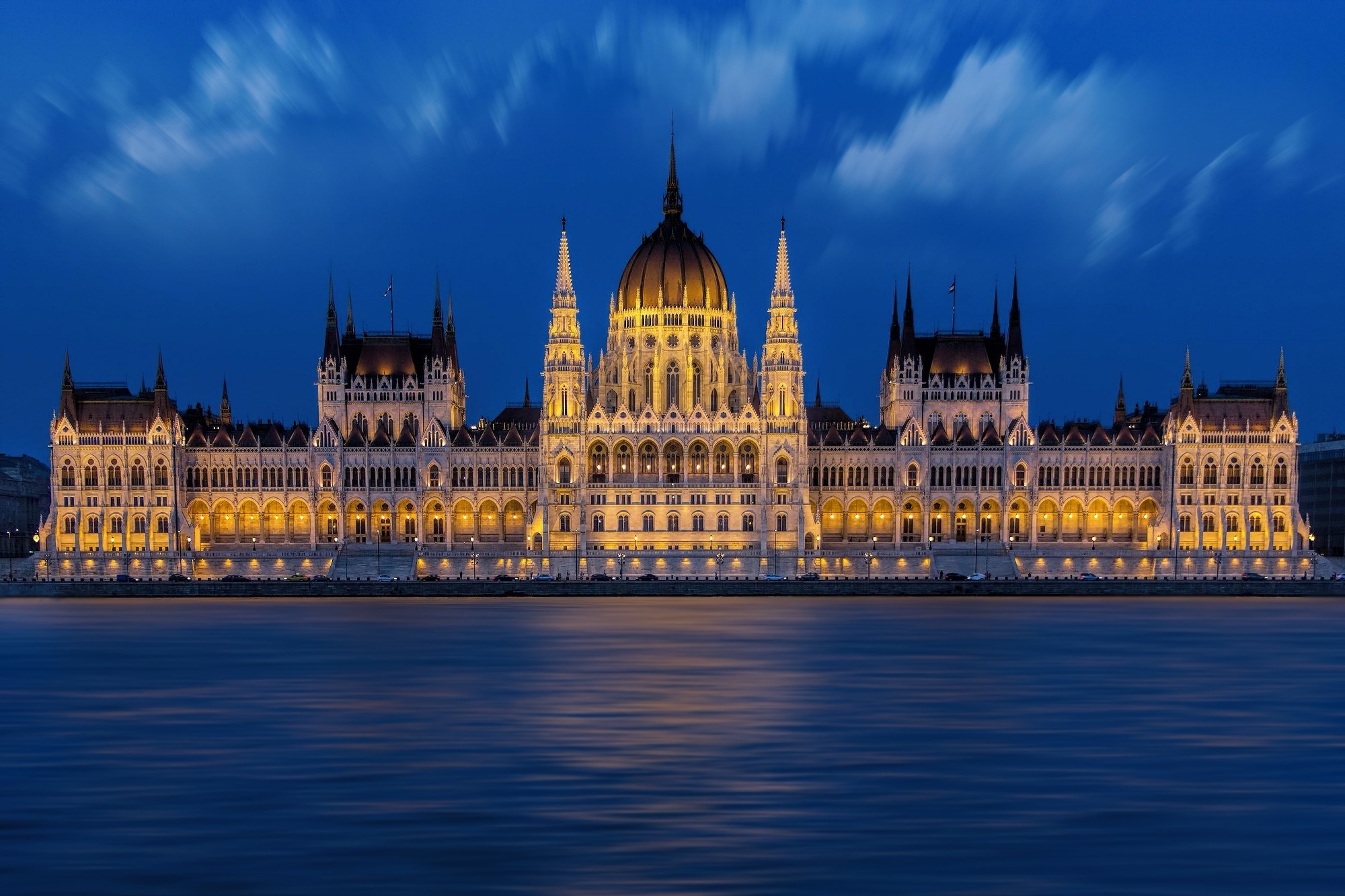
In the picture, there is a river with the parliament building located in Budapest. Indicate the name of the river flowing through the capital of Hungary.
- Rhine
- Rhône
- Danube
- Dniester
In the picture you can see the Danube River which flows through territories of many countries. Indicate the countries that are not within a reach of its system.
- Moldova
- Croatia
- Germany
- Austria
- Slovakia
- Italy
- Bulgaria
Match the following lakes, located within Europe, with corresponding country in which specific lake lies.
| Ladoga | Russian Federation |
| Onega | Russian Federation |
| Como | Italy |
| Vättern | Sweden |
| Inari | Finland |
| Śniardwy | Poland |
| Balaton | Hungary |
| Garda | Italy |
| Vänern | Sweden |
Keywords
river, delta, glacier, estuary
Match the pairs: English words with Polish definition.
obszar, z którego wody powierzchniowe spływają do jednego zbiornika wodnego, głębokie, rozszerzające się ku morzu (lejek) ujście rzeczne powstające na wybrzeżach o dużych różnicach między przypływem a odpływem, co uniemożliwia osadzanie się materiału rzecznego, stożek palczasto rozgałęziony, usypany z materiału niesionego przez rzekę w jej ujściu do morza lub jeziora; nazwa pochodzi od dużej greckiej litery Delta (Δ) mającej kształt trójkąta, ogół naturalnych cieków wodnych (stałych, okresowych i epizodycznych) występujących na określonym obszarze, płytki odcinek szybko płynącej rzeki tworzący się często przed progiem skalnym, każdy naturalny odpływ wody w korycie płynący stale lub w określonym czasie, np. porze roku
| riffle | |
| river network | |
| watercourse | |
| catchment area | |
| estuary | |
| delta |
Glossary
bystrze - płytki odcinek szybko płynącej rzeki tworzący się często przed progiem skalnym
sieć rzeczna - ogół naturalnych cieków wodnych (stałych, okresowych i epizodycznych) występujących na określonym obszarze
rzeka - każdy naturalny odpływ wody w korycie płynący stale lub w określonym czasie, np. porze roku
obszar zlewni - obszar, z którego wody powierzchniowe spływają do jednego zbiornika wodnego
ujście - głębokie, rozszerzające się ku morzu (lejek) ujście rzeczne powstające na wybrzeżach o dużych różnicach między przypływem a odpływem, co uniemożliwia osadzanie się materiału rzecznego
delta - stożek palczasto rozgałęziony, usypany z materiału niesionego przez rzekę w jej ujściu do morza lub jeziora; nazwa pochodzi od dużej greckiej litery Delta (Δ) mającej kształt trójkąta