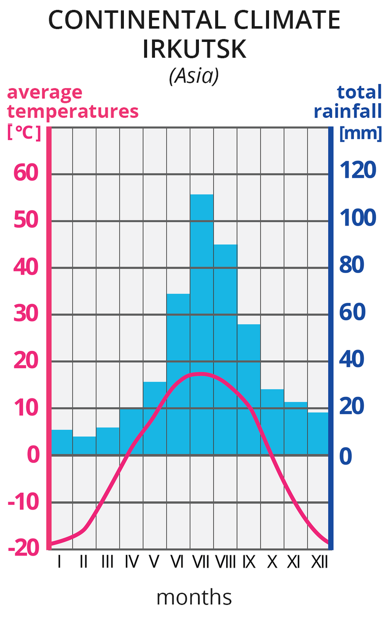
Ilustracja prezentuje wykres – klimatogram, klimatu kontynentalnego w Irkucku w Azji. Na lewej osi wykresu wyskalowano średnie temperatury w OC, na prawej osi wykresu wyskalowano sumy opadów w mm. Na osi poziomej zaznaczono cyframi rzymskimi kolejne miesiące. Czerwona pozioma linia na wykresie, to średnie temperatury w poszczególnych miesiącach. Tutaj linia rozpoczyna się na wysokości -20 OC w styczniu i wznosi się w poszczególnych miesiącach do około 19 OC w lipcu, po czym opada do -20 OC w grudniu. Niebieskie słupki, to wysokości sum opadów w poszczególnych miesiącach. Najwyższe opady, powyżej 40 mm, w miesiącach czerwiec-wrzesień. Opady, poniżej 20 mm w miesiącach listopad -kwiecień Ilustracja zawiera anglojęzyczne słownictwo: temperate climate, Irkutsk, Asia average temperature, total rainfall, months.
Climograph for Irkutsk
Source: Dariusz Adryan, licencja: CC BY 3.0.
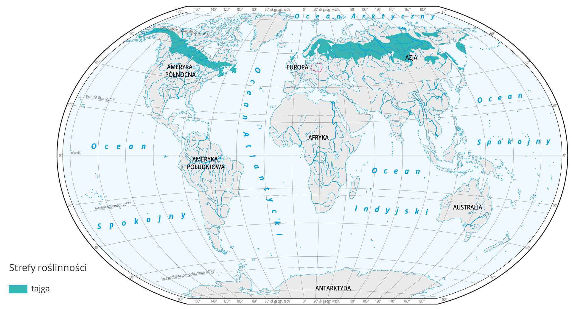
TaigataigaTaiga occupies vast areas of the northern hemisphere and stretch from the northern part of the Scandinavian Peninsula, through northern territories of the European part of the Russian Federation, Siberia, certain islands and peninsulas of the Far East and the greater part of Alaska and Canada.
The cool temperate climate zone on the northern hemisphere is characterised by severe climatic conditions. Winter lasts even up to 7 months there. In certain places, air temperature drops below –50°C. Spring and autumn are short, cold, cloudy and windy. Summer is short, sunny and warm, with an average air temperature of approximately 20°C, albeit quite dry. Rainfall per annum doesn’t exceed 600 mm, usually less. Such climate is called the dry continental climate.
R2ckiYHY1uCbW
Mapa świata prezentuje występowanie tajgi na Ziemi. Obszary tajgi oznaczone kolorem turkusowym na mapie występują w: północnej części Rosji, północnej części Półwyspu Skandynawskiego oraz północnej części Alaski i Kanady.
Taiga exists only on the northern hemisphere. Climate, vegetation and soil zones appear symetrically on both hemispheres at similar latitudes. This is not the case with taiga, as there are no land masses on the southern hemisphere where climatic conditions necessary for the formation of taiga forests could develop.
Source: Aleksandra Ryczkowska, Wydawnictwo Edukacyjne Wiking, licencja: CC BY 3.0.
The harsh climate means that only plants that are adapted to a very long and cold winter as well as animals with thick and warm fur can survive there. Taiga is the largest coniferous forest area in the world. Trees have a widespread and shallow root system, as at the depth of approx. 1–3 metres there is a layer of frozen rock called permafrostpermafrostpermafrost. It exists on extremely vast areas of our planet and its thickness is highly diverse, varying from 1 to 1600 m. In the summer, only the surface layer of soil thaws, its thickness varied. As water cannot be absorbed into the substrate due to it being frozen, a boggy marsh is formed on the surface. Widespread roots of the trees help them survive in soggy soil.
RKvCoeRQiDUbv
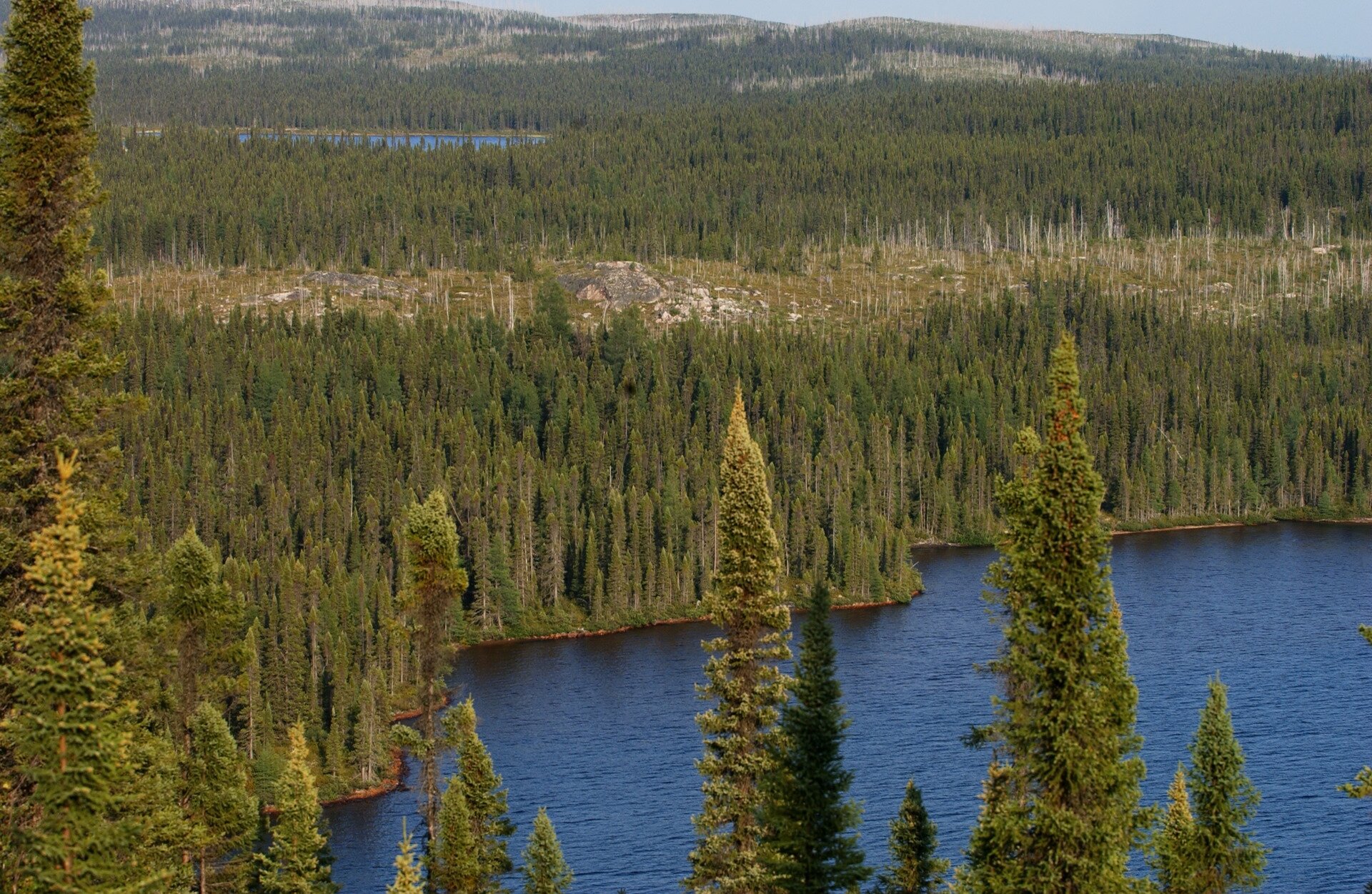
Fotografia prezentuje krajobraz tajgi latem. Na fotografii wykonanej z wysokości widoczne wierzchołki świerków na tle jeziora oraz gęsty las świerkowy rozciągający się po horyzont.
Taiga landscape from a bird’s eye view
Source: peupleloup, www.flickr.com, licencja: CC BY-SA 2.0.
Humans living in the taiga
Taiga is an area that is very unfriendly to humans. For many months in the year it’s extremely cold. In the summer, there are millions of mosquitoes and small but blood‑sucking flies. The surface is covered in mud due to the shallow permafrost layer. There aren’t many areas suitable to build houses.
Despite the adverse conditions, humans have continued to settle in the taiga for a long time. At the beginning, these were primarily hunters hunting for various animals due to the high price of their furs and pelts. Fishermen also arrived, as in the summer period it’s possible to catch fish in big rivers. The next to arrive we lumberjacks that felled large tracts of forests.
The territories covered by the taiga are rich in metal ore, coal, oil and natural gas deposits as well as other resources, such as precious stones. However, it was only in the 20th century when technological progress made it possible to build mines, smelting plants, power plants and manufacturing plants as well as houses for workers in the taiga that the mining of its natural resources began on a mass scale.
RYcJM9Jmx6DGx
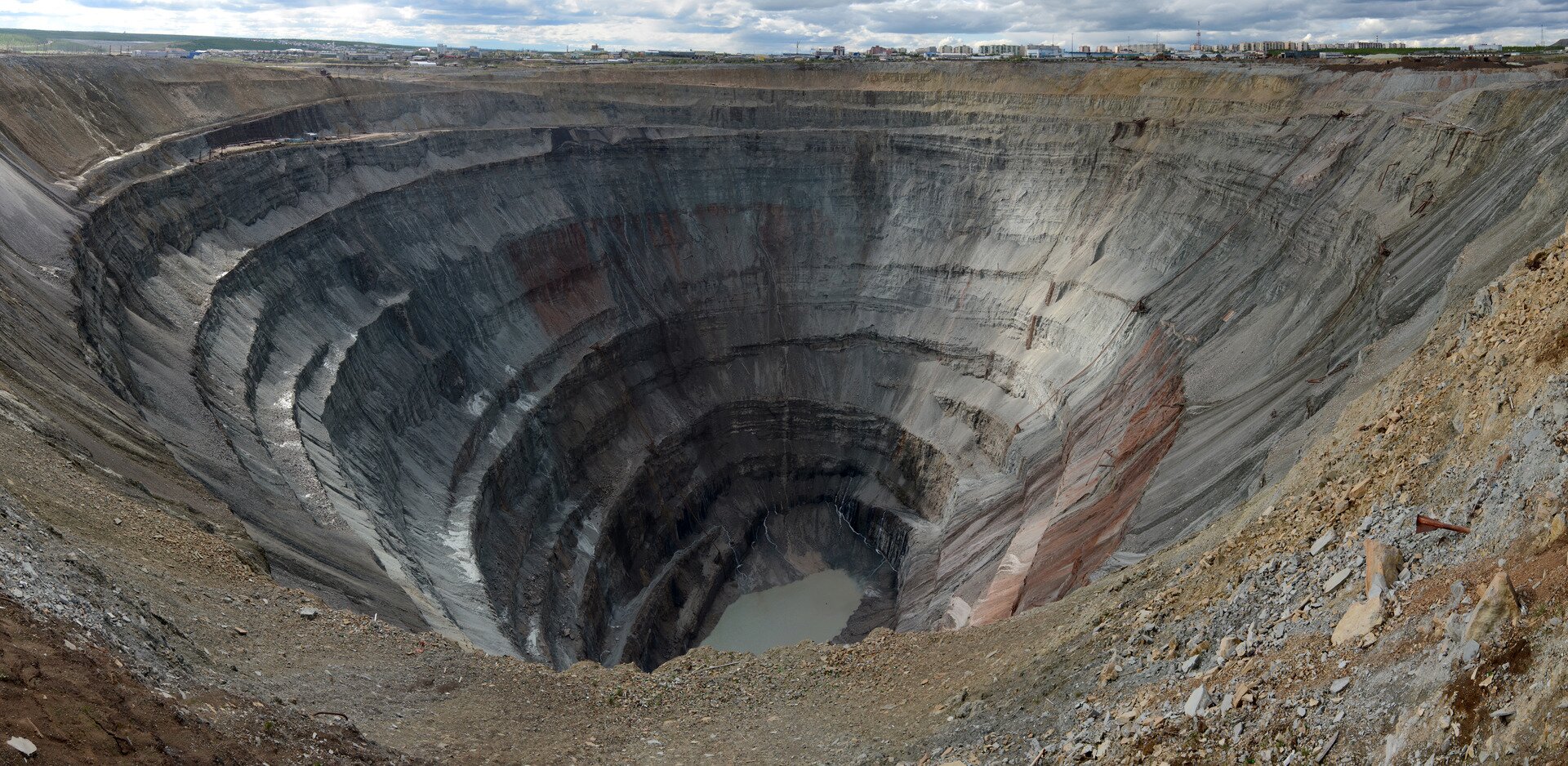
Fotografia prezentuje głęboki i szeroki lej w ziemi, po kopalni diamentów we wschodniej Syberii w Mirny. Lej zwęża się schodkowo do dna dziury. Na dnie widać wodę. Kolor wyrobiska szary z brązowymi fragmentami.
Closed diamond mind in Mirny in eastern Siberia
Source: Staselnik, http://commons.wikimedia.org, licencja: CC BY-SA 3.0.
Important!
It’s extremely difficult and in certain places even impossible to cultivate soil. The summer, when plant vegetation is possible, lasts for a short period but soils during that period are too wet. As a result, taiga residents are often short on food of plant origin and must import it from other regions.
Warning!
The hunting for rare animals that inhabit the taiga, the felling of its most precious trees and the development of mining, smelting and energy production on a mass scale are a major threat to nature in this region.
R14YVUqtXq8Ts
Ilustracja przedstawia mapę z zaznaczoną linią kolei transsyberyjskiej. Na mapie dodano opisy i fotografie:
1. The Trans-Siberian Railway together with its branch lines is one of the longest railway lines in the world.-The route beginning in Europe and ending on the Pacific coast runs through 9,332 km of the taiga, steppes and mountains.,
2. Fotografia przedstawia stację kolejową w Nazywajewsku.- Railway station in Nazyvayevsk,
3. Fotografia przedstawiająca tory linii kolei transsyberyjskiej nad jeziorem Bajkał.- Railway tracks over Lake Baikal,
4. Fotografia przedstawia słup z odległością 9288 km na stacji we Władywostoku.- Milepost indicating 9288 km to destination at the station in Vladivostok
Trans-Siberian Railway Line
Source: Francorov, Petar Milošević, Toen96, GroMar Sp. z o.o., licencja: CC BY-SA 3.0.
RT0yOAQMVOHJL
Exercise 1
Ćwiczenie uzupełnij luki w tekście. Complete the sentences using words from the list. The taiga is characterised primarily by (uzupełnij) 1. short, 2. hot, 3. cold, 4. deciduous, 5. coniferous, 6. short, 7. drop, 8. long, 9. mild, 10. long, 11. increase, 12. warm, 13. rise trees. The winter is (uzupełnij) 1. short, 2. hot, 3. cold, 4. deciduous, 5. coniferous, 6. short, 7. drop, 8. long, 9. mild, 10. long, 11. increase, 12. warm, 13. rise, cold and snowy.
In winter, the temperature can (uzupełnij) 1. short, 2. hot, 3. cold, 4. deciduous, 5. coniferous, 6. short, 7. drop, 8. long, 9. mild, 10. long, 11. increase, 12. warm, 13. rise to -50°C. The summer is (uzupełnij) 1. short, 2. hot, 3. cold, 4. deciduous, 5. coniferous, 6. short, 7. drop, 8. long, 9. mild, 10. long, 11. increase, 12. warm, 13. rise and warm.
The taiga is characterised primarily by .................... trees. The winter is ...................., cold and snowy.
In winter, the temperature can .................... to -50°C. The summer is .................... and warm.
RIf7s8QxHYFE5
Exercise 2
Ćwiczenie wskaż, które zdania są prawdziwe, a które fałszywe. Decide if the following statement is true or false. Taiga can be found only in the northern hemisphere. Możliwe odpowiedzi: True, False. In the southern hemisphere, there are no land masses where climatic conditions necessary for the formation of taiga forests could develop. Możliwe odpowiedzi: True, False. The climate in the taiga is suitable for the cultivation of root crops. Możliwe odpowiedzi: True, False
Ćwiczenie wskaż, które zdania są prawdziwe, a które fałszywe. Decide if the following statement is true or false. Taiga can be found only in the northern hemisphere. Możliwe odpowiedzi: True, False. In the southern hemisphere, there are no land masses where climatic conditions necessary for the formation of taiga forests could develop. Możliwe odpowiedzi: True, False. The climate in the taiga is suitable for the cultivation of root crops. Możliwe odpowiedzi: True, False
Decide if the following statement is true or false.
True
False
Taiga can be found only in the northern hemisphere.
□
□
In the southern hemisphere, there are no land masses where climatic conditions necessary for the formation of taiga forests could develop.
□
□
The climate in the taiga is suitable for the cultivation of root crops.
□
□
Summary
The coniferous forest known as taiga grows in the cold part of the temperate continental climate zone and covers the largest area.
Winter in the taiga is long and cold, whereas summer is short and warm.
Taiga can be found only in the northern hemisphere.
People living in the taiga live off of hunting, felling trees, mining and other industrial operations.
Match the pairs: English words with Polish definition. permafrost Możliwe odpowiedzi: 1. zwana także borealnym lasem iglastym; zespół ekosystemów o zbliżonych warunkach klimatycznych, podobnej strukturze przestrzennej oraz zbliżonej florze i faunie - zwany biomem- występujący w klimacie umiarkowanym chłodnym, dla którego charakterystyczne są długie okresy mroźnych zim oraz niska roczna suma opadów (400‑600 mm); typowa dla tego biomu formacja roślinna to las iglasty, 2. inaczej wieloletnia zmarzlina; zjawisko utrzymywania się powierzchni skorupy ziemskiej w temperaturze poniżej punktu zamarzania wody o każdej porze roku; obejmuje większość terytorium Alaski i północnej Kanady oraz Syberii taiga Możliwe odpowiedzi: 1. zwana także borealnym lasem iglastym; zespół ekosystemów o zbliżonych warunkach klimatycznych, podobnej strukturze przestrzennej oraz zbliżonej florze i faunie - zwany biomem- występujący w klimacie umiarkowanym chłodnym, dla którego charakterystyczne są długie okresy mroźnych zim oraz niska roczna suma opadów (400‑600 mm); typowa dla tego biomu formacja roślinna to las iglasty, 2. inaczej wieloletnia zmarzlina; zjawisko utrzymywania się powierzchni skorupy ziemskiej w temperaturze poniżej punktu zamarzania wody o każdej porze roku; obejmuje większość terytorium Alaski i północnej Kanady oraz Syberii
Match the pairs: English words with Polish definition. permafrost Możliwe odpowiedzi: 1. zwana także borealnym lasem iglastym; zespół ekosystemów o zbliżonych warunkach klimatycznych, podobnej strukturze przestrzennej oraz zbliżonej florze i faunie - zwany biomem- występujący w klimacie umiarkowanym chłodnym, dla którego charakterystyczne są długie okresy mroźnych zim oraz niska roczna suma opadów (400‑600 mm); typowa dla tego biomu formacja roślinna to las iglasty, 2. inaczej wieloletnia zmarzlina; zjawisko utrzymywania się powierzchni skorupy ziemskiej w temperaturze poniżej punktu zamarzania wody o każdej porze roku; obejmuje większość terytorium Alaski i północnej Kanady oraz Syberii taiga Możliwe odpowiedzi: 1. zwana także borealnym lasem iglastym; zespół ekosystemów o zbliżonych warunkach klimatycznych, podobnej strukturze przestrzennej oraz zbliżonej florze i faunie - zwany biomem- występujący w klimacie umiarkowanym chłodnym, dla którego charakterystyczne są długie okresy mroźnych zim oraz niska roczna suma opadów (400‑600 mm); typowa dla tego biomu formacja roślinna to las iglasty, 2. inaczej wieloletnia zmarzlina; zjawisko utrzymywania się powierzchni skorupy ziemskiej w temperaturze poniżej punktu zamarzania wody o każdej porze roku; obejmuje większość terytorium Alaski i północnej Kanady oraz Syberii
Match the pairs: English words with Polish definition.
zwana także borealnym lasem iglastym; zespół ekosystemów o zbliżonych warunkach klimatycznych, podobnej strukturze przestrzennej oraz zbliżonej florze i faunie - zwany biomem- występujący w klimacie umiarkowanym chłodnym, dla którego charakterystyczne są długie okresy mroźnych zim oraz niska roczna suma opadów (400‑600 mm); typowa dla tego biomu formacja roślinna to las iglasty, inaczej wieloletnia zmarzlina; zjawisko utrzymywania się powierzchni skorupy ziemskiej w temperaturze poniżej punktu zamarzania wody o każdej porze roku; obejmuje większość terytorium Alaski i północnej Kanady oraz Syberii
wieczna zmarzlina – inaczej wieloletnia zmarzlina; zjawisko utrzymywania się powierzchni skorupy ziemskiej w temperaturze poniżej punktu zamarzania wody o każdej porze roku; obejmuje większość terytorium Alaski i północnej Kanady oraz Syberii
tajga – zwana także borealnym lasem iglastym; zespół ekosystemów o zbliżonych warunkach klimatycznych, podobnej strukturze przestrzennej oraz zbliżonej florze i faunie - zwany biomem- występujący w klimacie umiarkowanym chłodnym, dla którego charakterystyczne są długie okresy mroźnych zim oraz niska roczna suma opadów (400‑600 mm); typowa dla tego biomu formacja roślinna to las iglasty