The maritime economy involves very wide range of branches, which transcened fishery and exploatation of other natural resources. It includes ship industry, transport and logistics. The development of the maritime economy would not be possible without research and maritime education. To this branch of economy belongs also maritime and seaside tourism, involved with natural and cultural advantages, and the management, which introduces the operating rules within the maritime area.
Shipping
RkH1k6ISImCRj
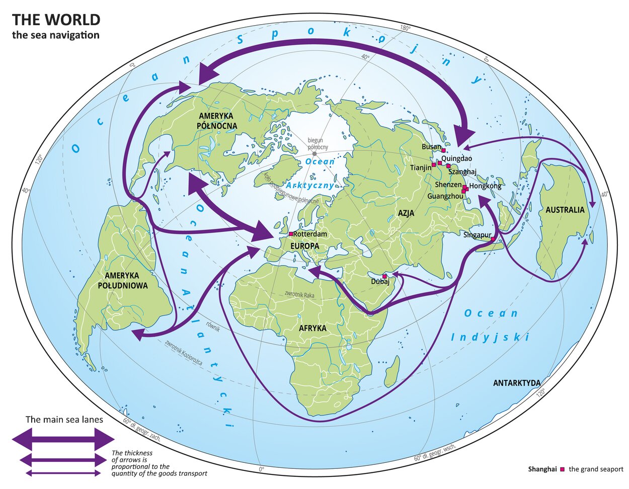
Ilustracja przedstawia mapę świata. Na mapie oznaczono wody i kontynenty. Opisano nazwy kontynentów i oceanów. Za pomocą sygnatur ( kwadrat) oznaczono wielkie porty morskie, które również opisano.Za pomocą strzałek przedstawiono główne szlaki morskie. Grubości strzałek są proporcjonalne do wielkości przewozów towarowych.Najgrubsze strzałki są między Ameryką Północną i Europą oraz Ameryką Północną i wschodnim wybrzeżem Azji. Węższe strzałki poprowadzono między Europą i Ameryką Południową, między Europą a wschodnim wybrzeżem Azji przez Kanał Sueski oraz między Europą a zachodnim wybrzeżem Ameryki Północnej przez Kanał Panamski.Najwęższa strzałka przebiega wokół Afryki i Australii.Mapa pokryta jest równoleżnikami i południkami. Dookoła mapy w białej ramce opisano współrzędne geograficzne co czterdzieści stopni.Na dole mapy opisano znaki użyte na mapie. Tłumaczenie: Œwiat - The world ¯egluga morska - The sea navigation Główne szlaki morskie - The main sea lanes Grubości strzałek są proporcjonalne do wielkości przewozów towarowych - The thickness of arrows is proportional to the quantity of the goods transport Szanghaj wielki port morski - Shanghai the grand seaport.
The sea navigation. The main sea lanes.
Source: Wydawnictwo Edukacyjne Wiking, licencja: CC BY 3.0.
The area, which is exploited the most, is the North Atlantic and the North Pacific. The import ant route connects the Eastern and South Asia with Europe. The shape of the shoreline induces the concentration of moving in the Strait of Malacca, and owing to the Suez Canal also on the Red Sea and on the Mediterranean Sea. In turn owing to the Panama Canal the ships, which set out for example from the west coast of North America for ports on the east coast, for Europe or Africa, do not have to round South America. Low volume of shipping on the southern hemisphere results mainly in vulnerability of local economies, and also in the smaller quantity of lands. Admittedly, Australia, situated in the southern part of the globe, has a strong economy and exports sources, but its domestic market is limited because of relatively small number of habitants.
Task 1
Describe the branches of fishery.
RGYEq7sDS6Kth
Wykonaj ćwiczenie zgodnie z poleceniem.
Wykonaj ćwiczenie zgodnie z poleceniem.
Fishery
Fish and sea food are the worthy food product. Therefore there were engaged the more and more advanced technologies over the years to source them. In the second half of the XX century the quantity of fishings increased four times in relation to the level from the end of the fourties. In next years stagnancy commenced. Using sonars, and even satelites gave shoals of fish no chances for avoiding thinning them out. The less and less fish grew up and could procreate. Their number decreased dramatically from year to year. This was the best proof for the decrease in the number of fish because of the excessive exploitation of fishing grounds. The estimates point out, that 84% fishing grounds are on the verge of overfishing or they are already overfished.
R1ApyKJfKOXuF
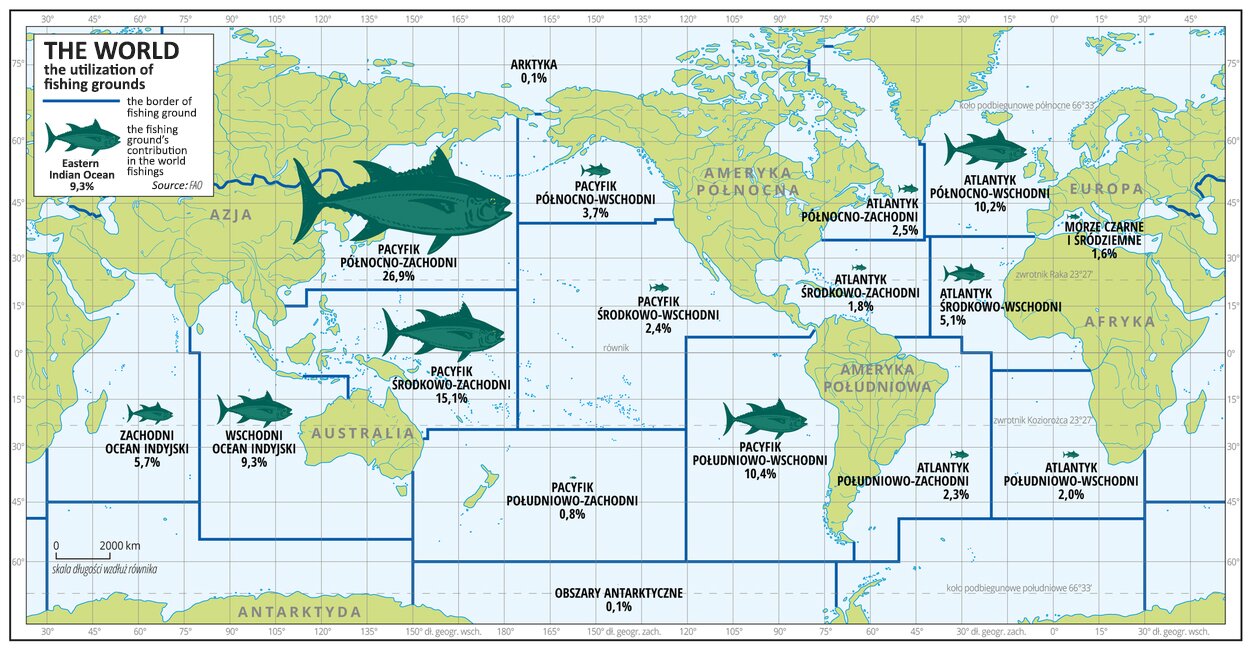
Ilustracja przedstawia mapę świata. Na mapie oznaczono wody. Opisano kontynenty.Na mapie za pomocą linii przedstawiono granice łowisk. Na obszarze Oceanu Spokojnego i Atlantyckiego wydzielono po sześć łowisk, na obszarze Oceanu Indyjskiego – dwa łowiska. Za pomocą sygnatur ryb o zróżnicowanej wielkości przedstawiono udział danego łowiska w połowach światowych. Opisano wartości liczbowe w procentach. Największa sygnatura znajduje się na terenie łowiska Pacyfiku Północno-Zachodniego – dwadzieścia sześć procent udziału łowiska w połowach światowych. Mapa pokryta jest równoleżnikami i południkami. Dookoła mapy w ramce opisano współrzędne geograficzne co piętnaście stopni. Na górze w legendzie mapy objaśniono znaki użyte na mapie.
Największe łowiska to Pacyfik północno - zachodni 26,9%. Pacyfik środkowo - zachodni 15,1%. Pacyfik południowo - wschodni 10,4 % udziału w rynku światowym.
The utilization of fishing grounds
Source: licencja: CC BY 3.0.
Though the oceans cover the most part of the Earth’s surface, relatively not big part of them provides potential fishing grounds. They involve mainly areas with subsurface water, rich in organisms, which include chlorophyl.
R1Vm2N3MjVzrv
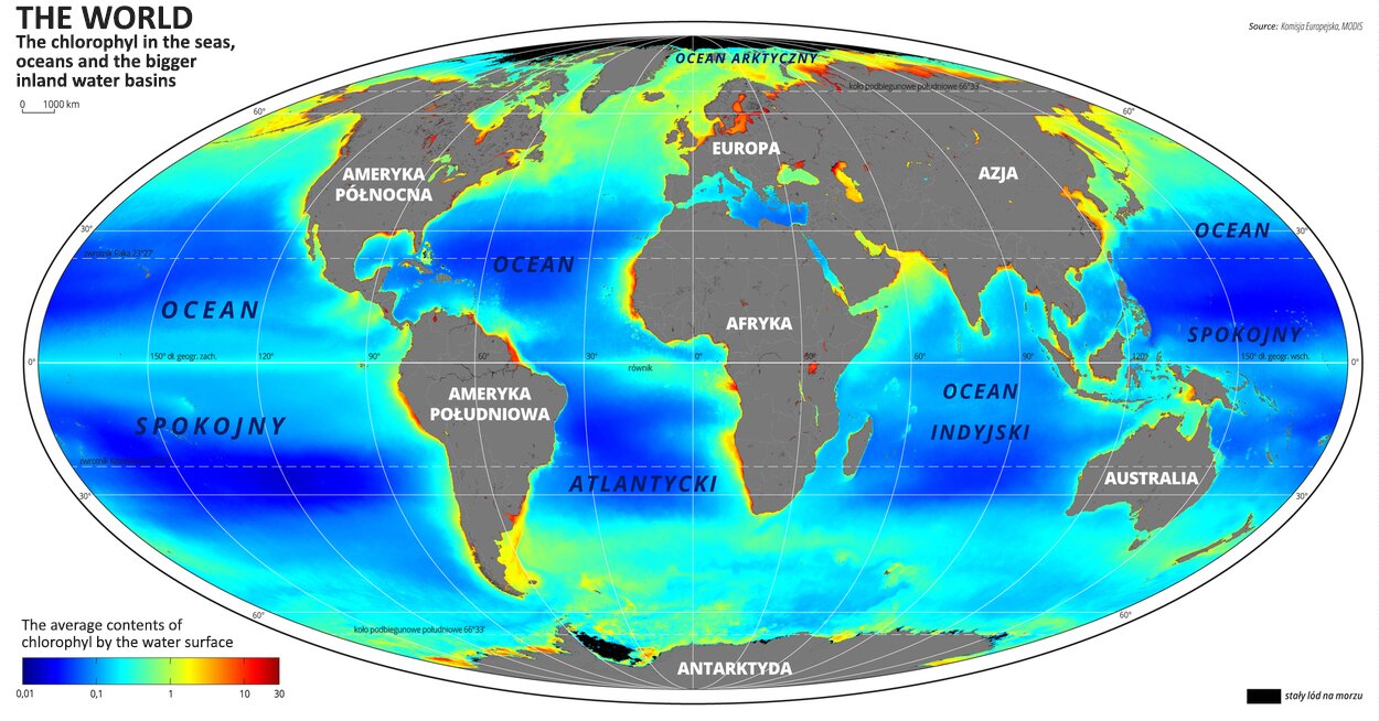
Ilustracja przedstawia mapę świata. Opisano na niej kontynenty.Na mapie przedstawiono średnią zawartość chlorofilu w morzach, oceanach i większych zbiornikach śródlądowych. Mapa pokryta jest równoleżnikami i południkami. Dookoła mapy w ramce opisano współrzędne geograficzne co trzydzieści stopni.Na dole mapy po lewej stronie umieszczono poziomy legendę mapy.
The chlorophyl in the seas, oceans and the bigger inland water basins. The average contents of chlorophyl by the water surface.
Source: Wydawnictwo Edukacyjne Wiking, licencja: CC BY 3.0.
Task 2
Find: the main fishing grounds in the world, the quantity of the fishings in the world and the consumption of fish in the chosen countries in the world and write it down below.
R1I4no2QkGCmu
Wykonaj ćwiczenie zgodnie z poleceniem.
Wykonaj ćwiczenie zgodnie z poleceniem.
The agenda of UN for Food and Agriculture (FAO) divided seas and oceans into 19 areas, but over 75% fishings comes from only six of them. Only six countrties source 50% sea fish in the whole world. The table below presents the countries with the greatest fishings in 2012 (according to FAO).
Country
Fishings (mln t)
Persentage of the world fishings(%)
1
China
13.9
17
2
Indonesia
5.4
7
3
USA
5.1
6
4
Peru
4.8
6
5
Russia
4.1
5
6
Japan
3.6
5
7
India
3.3
4
One of the ways of limiting the fishery is the cultivation of marine organisms. In such a way i.a. about 5,5 mln t fish a year can be sourced. The table presents the leading countries.
Country
Quantity of production (mln t)
Quantity of production on 1 employed(t)
Norway
1.3
195
China
1.0
7
Chile
0.8
55
Indonesia
0.6
1
Philipines
0.4
n.d.
Natural resources
ROKcYYlMZOZlT
Name the mineral sources, which are sourced from the seas and oceans.
Name the mineral sources, which are sourced from the seas and oceans.
Source: licencja: CC 0.
The sea water is rich in elements and compounds, but their concentration is mostly too small, so it is not worth to source them. An exception is the salt (NaCl), which is being got by the method, which involves evaporating the sea water.
For almost over 100 years the earth gas and mineral oil have been sourced from under the sea bottom. This is typical for Persian Gulf, Gulf of Mexico and North Sea. In this way Brasil will utilize its new deposits.
Task 3
Describe the consequences of the intensive exploitation of water resources. Develop the subject creating below the Metaplan.
Problem: The consequences of the intensive exploitation of water sources
Rbrshh2Bg4X1c
Wykonaj ćwiczenie zgodnie z poleceniem.
Wykonaj ćwiczenie zgodnie z poleceniem.
RTfvNWgiviUKb
Exercise 1
Point out three countries, which place at the top in the world in the quantity of sourced fish. Możliwe odpowiedzi: 1. China, 2. Sweden, 3. Indonesia, 4. USA, 5. Mexico, 6. Saudi Arabia
Point out three countries, which place at the top in the world in the quantity of sourced fish. Możliwe odpowiedzi: 1. China, 2. Sweden, 3. Indonesia, 4. USA, 5. Mexico, 6. Saudi Arabia
Point out three countries, which place at the top in the world in the quantity of sourced fish.
China
Sweden
Indonesia
USA
Mexico
Saudi Arabia
RNfZbqE73tqQK
Exercise 2
Fill in the gaps in sentences below. The maritime economy is a wide question, which involves1. 90%, 2. black coal, 3. Asia, 4. protection, 5. polymetallic nodules, 6. research, 7. North America, 8. 50%, 9. management, utilization of the sea sources, technologies, which are useful by the exploitation,1. 90%, 2. black coal, 3. Asia, 4. protection, 5. polymetallic nodules, 6. research, 7. North America, 8. 50%, 9. management of the natural and cultural sources and economic, law, political, and also educational questions. Over 1. 90%, 2. black coal, 3. Asia, 4. protection, 5. polymetallic nodules, 6. research, 7. North America, 8. 50%, 9. management of the world trade takes place seaway. The greatest transports take place between Europe, 1. 90%, 2. black coal, 3. Asia, 4. protection, 5. polymetallic nodules, 6. research, 7. North America, 8. 50%, 9. management and eastern Asia. Mineral oil is being sourced from under the sea bottom and the foreseen exploitation of1. 90%, 2. black coal, 3. Asia, 4. protection, 5. polymetallic nodules, 6. research, 7. North America, 8. 50%, 9. management are the relevant factors of the maritime environment’s pollution.
Fill in the gaps in sentences below. The maritime economy is a wide question, which involves1. 90%, 2. black coal, 3. Asia, 4. protection, 5. polymetallic nodules, 6. research, 7. North America, 8. 50%, 9. management, utilization of the sea sources, technologies, which are useful by the exploitation,1. 90%, 2. black coal, 3. Asia, 4. protection, 5. polymetallic nodules, 6. research, 7. North America, 8. 50%, 9. management of the natural and cultural sources and economic, law, political, and also educational questions. Over 1. 90%, 2. black coal, 3. Asia, 4. protection, 5. polymetallic nodules, 6. research, 7. North America, 8. 50%, 9. management of the world trade takes place seaway. The greatest transports take place between Europe, 1. 90%, 2. black coal, 3. Asia, 4. protection, 5. polymetallic nodules, 6. research, 7. North America, 8. 50%, 9. management and eastern Asia. Mineral oil is being sourced from under the sea bottom and the foreseen exploitation of1. 90%, 2. black coal, 3. Asia, 4. protection, 5. polymetallic nodules, 6. research, 7. North America, 8. 50%, 9. management are the relevant factors of the maritime environment’s pollution.
Fill in the gaps in sentences below.
black coal, Asia, protection, research, North America, 50%, polymetallic nodules, 90%, management
The maritime economy is a wide question, which involves........................................, utilization of the sea sources, technologies, which are useful by the exploitation,........................................ of the natural and cultural sources and economic, law, political, and also educational questions. Over ........................................ of the world trade takes place seaway. The greatest transports take place between Europe, ........................................ and eastern Asia. Mineral oil is being sourced from under the sea bottom and the foreseen exploitation of........................................ are the relevant factors of the maritime environment’s pollution.
Rb01KpofHcWP9
Exercise 3
Przypomnij sobie tytuł abstraktu, wysłuchaj nagrania i spróbuj zaproponować własny temat dla dzisiejszej lekcji.
Przypomnij sobie tytuł abstraktu, wysłuchaj nagrania i spróbuj zaproponować własny temat dla dzisiejszej lekcji.
Source: licencja: CC 0.
RrmJfBG3EUdr1
Exercise 4
Wybierz jedno nowe słowo poznane podczas dzisiejszej lekcji i ułóż z nim zdanie.
Wybierz jedno nowe słowo poznane podczas dzisiejszej lekcji i ułóż z nim zdanie.
Source: licencja: CC 0.
RCMueN85g4RRg
Exercise 5
Wysłuchaj nagrania abstraktu, wyodrębnij jego części i nadaj im tytuły.
Wysłuchaj nagrania abstraktu, wyodrębnij jego części i nadaj im tytuły.
marikultura - hodowla organizmów morskich: ryb, mięczaków, stawonogów, glonów i innych w celach konsumpcyjnych i gospodarczych, ale również wykorzystywana w celach rozmnażania innych, rzadkich gatunków morskich stworzeń, forma akwakultury.
akwakultura - forma gospodarki, mająca na celu zwiększenie pozyskiwania żywności ze środowiska wodnego. Polega na hodowli wybranych rodzajów organizmów wodnych.
rybołówstwo - zespół planowanych i skoordynowanych czynności mających na celu racjonalne gospodarowanie organizmami wodnymi w myśl zasad ekonomii i zgodnie z założeniami ochrony przyrody.
rybołówstwo śródlądowe - gałąź gospodarki obejmująca chów, hodowlę organizmów wodnych i pozyskiwanie ryb ze sztucznych zbiorników wodnych, rzek i jezior.