Types of water
how water circulates in nature;
states of aggregation that water can be found in;
what the source (spring), river (main river, tributary), river basin, basin, lake, sea are.
You will discuss the circulation of water in nature;
indicate the main rivers and their tributaries in Poland;
indicate rivers flowing into the Baltic Sea, the Black Sea and the North Sea;
discuss how rivers are supplied;
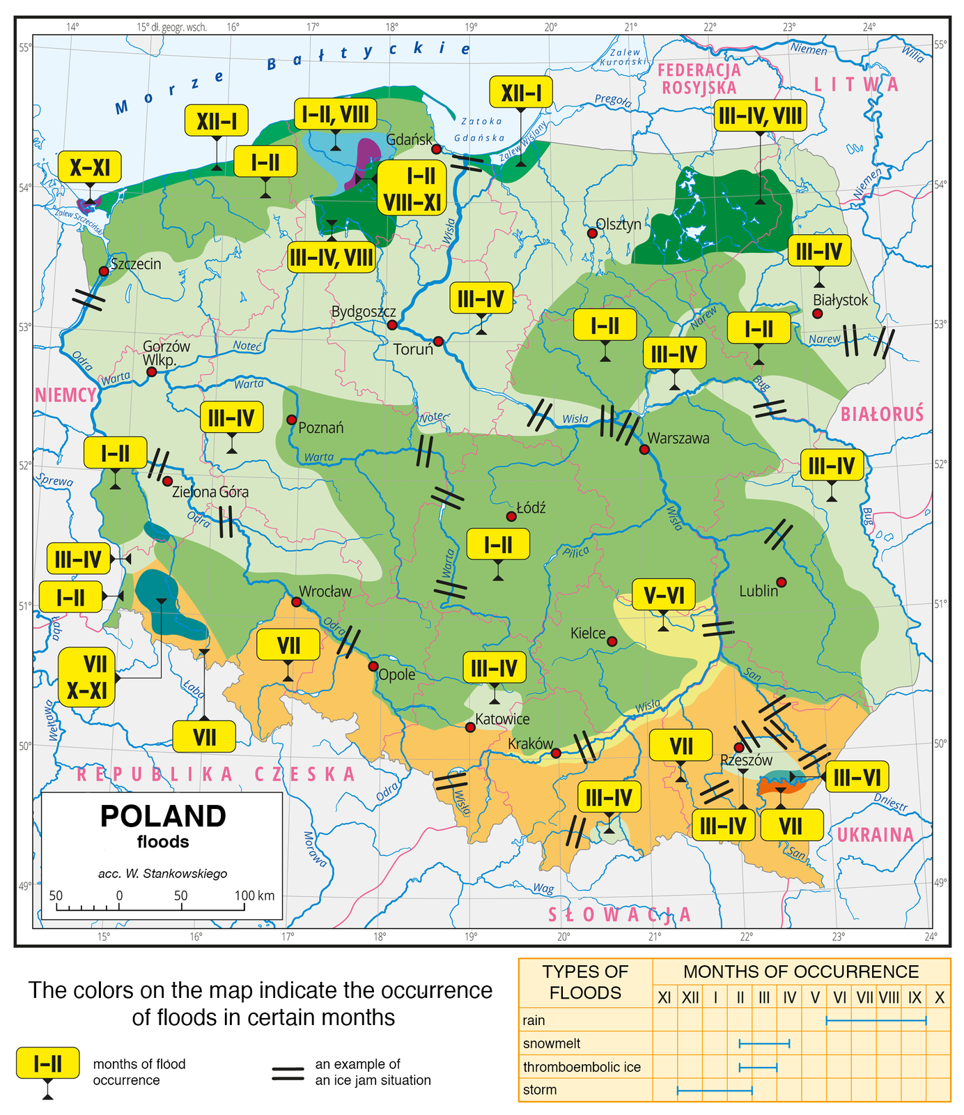
show the locations in Poland of the greatest risk of floods;
provide ways to protect against floods.
Water that falls to the surface of the Earth in the form of rain or snow evaporates, flows into the nearest river (and further to the sea), and soaks into the soil, feeding groundwaters. From the underground it flows to the surface as a source giving the beginning of a new river, which, in turn, falls into a different, larger one, or into lakes and seas. All waters located on the surface of the Earth evaporate, i.e. they change into water vapour, which cools in the atmosphere and condensates, and falls to the Earth again as precipitation.
This is the simplified version of the circulation of water in nature.
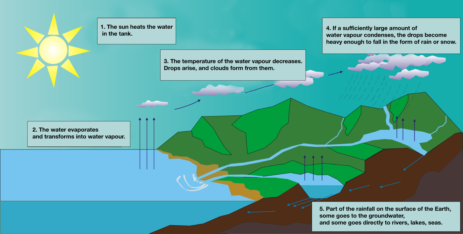
The entire water layer surrounding the Earth is called the hydrospherehydrosphere. As it moves through nature, water changes its location, physical state and speed. Now that we’ve agreed on this, we can generally classify water as water above the ground, on ground surface and under the ground.
Flowing surface waters of Poland
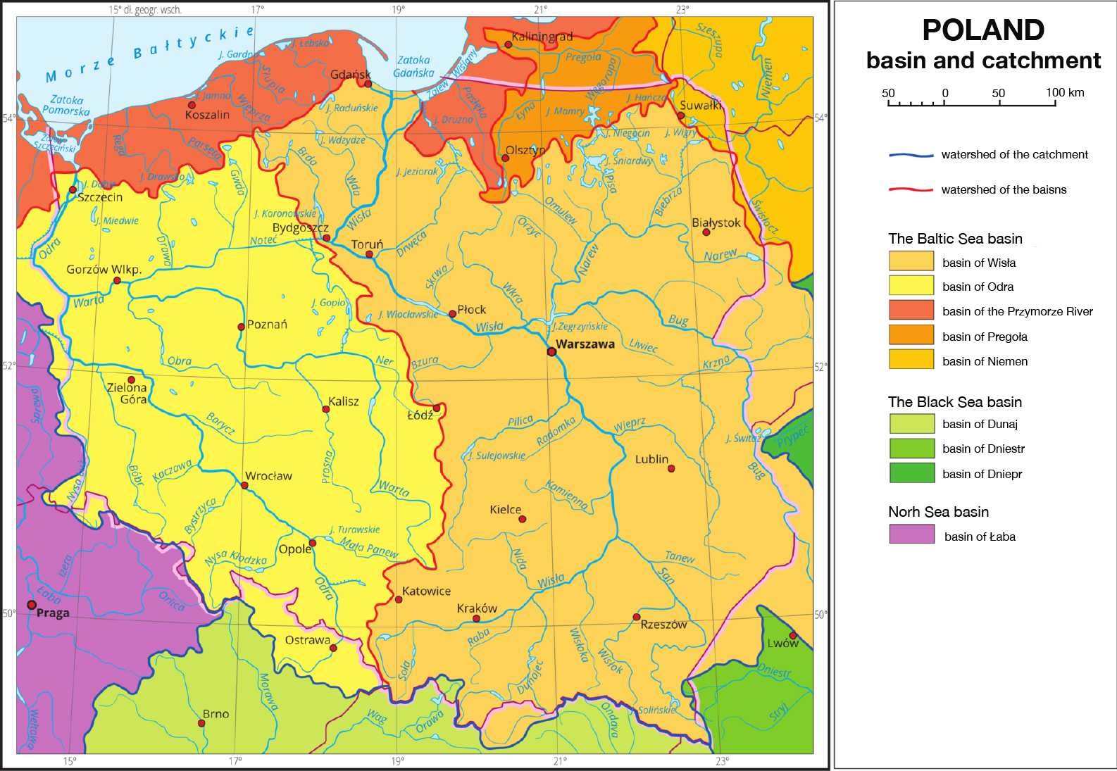
The two largest rivers of our country are the Vistula River and the Oder River. Almost 90% of Poland's area belongs to their basin – this means that from such a large area water first flows to these two main rivers, and then to the Baltic Sea through tributaries. There are also many small rivers from the area called the coastal area that flowflow directly into the Baltic Sea. In total, the catchment area of the Baltic Sea includes 99.7% of the area of Poland.
The sizes of river basins in Poland are presented in the table and the diagram below.
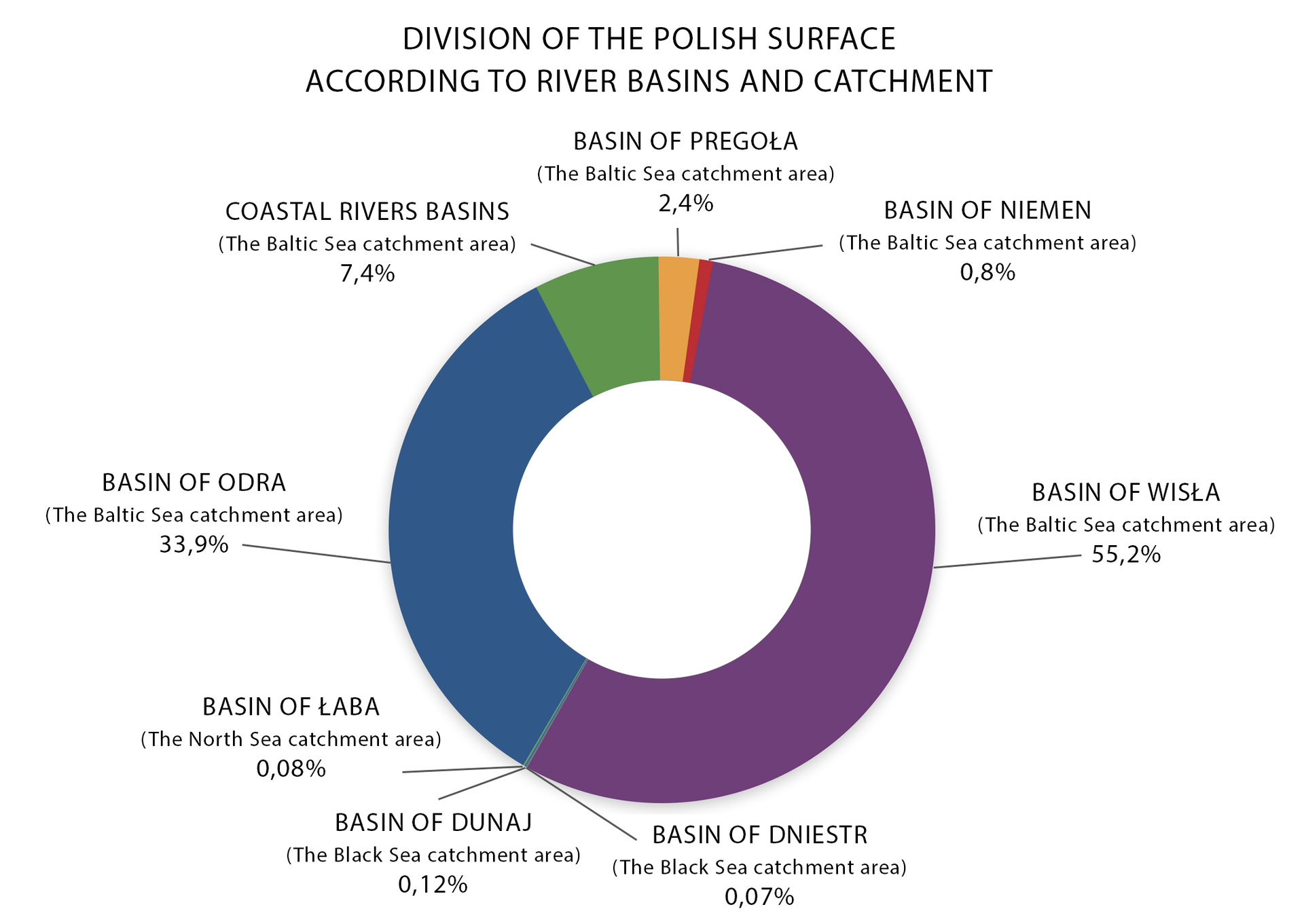
There are very small areas of Poland from where surface waters flow into seas other than the Baltic Sea:
from the Carpathians to the Black Sea – the upper course of the Orava River belongs to the Danube basin, and the upper course of the Strwiąż River to the Dniester basin;
from the Sudetes to the North Sea – short sections of the Jizera River and the Orlice River flow to the Elbe basin.
Assign the tributaries below to the appropriate river.
Bystrzyca, Warta, San, Biebrza, Dunajec, Nysa Kłodzka, Bóbr, Wkra, Skrwa, Wisłoka, Tanew, Bug, Barycz, Drawa, Brda, Pilica, Wieprz, Raba, Nida
| Vistula | |
|---|---|
| Oder |
A characteristic feature of the Vistula basin and the Odra basin is their asymmetry. The ratio of the left‑to‑right basin area is 27:73 for Vistula, and 30:70 for Oder. Both rivers have far more right tributaries than left. The main reason for the afore‑mentioned is the direction of the river network during the Pleistocene glaciation period in accordance with the general slope of Poland, i.e. from the south‑west to the north‑west.
ur rivers have a snow‑rain river regimeriver regime, which is distinguished by high water levels in spring and in summer.
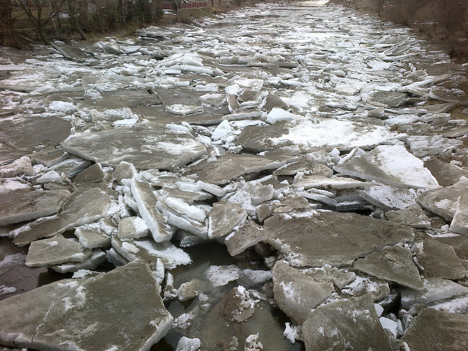
High water levels are observed in spring due to snowmelt, particularly in mountainous areas. This causes so much water to enter the water cycle that some rivers overflow. High water levels are additionally caused by ice jams which hamper water outflow to the Baltic Sea. Moreover, Poland still lacks sufficient safeguards: rivers are unregulated, flood embankments are not high enough and the number of retentionretention reservoirs is insufficient. In summer, high water levels in rivers are observed in late June and in July. These result from frequent and heavy seasonal rainfall, especially in the mountains. Lowest water levels in Polish rivers are witnessed in the late summer, early autumn (low precipitation) and winter, when large water amounts are stored as snow and ice. Seaside rivers sometimes experience so‑called storm surges. Storm surges occur when persisting northern winds push Baltic Sea waters into river mouths, raising river water levels and blocking river outflow.
The longest and the largest river – Vistula – has 1047 km of length, 173 thousand km Indeks górny 22 of the river basin area (within Poland) and 1080 m Indeks górny 33/s of average flowflow at the estuary. Its sources are located on the slopes of Barania Góra (Silesian Beskids). At its beginning, it is a mountain stream, but already from the Oświęcimska Basin it becomes a lowland river. In the vicinity of Elbląg and Gdańsk, the Vistula River builds a delta, separating into several branches, such as Nogat, Szkarpawa or Leniwka. However, it flows into the Baltic Sea through an artificial pier near Świbno, which was opened in 1895.
The sources of Oder – the second longest river in Poland – are located in the Oder Mountains (Oderské vrchy in Moravia, the Czech Republic) at an altitude of 634 m above sea level. The total length of the Oder River is 854 km, of which the section of 742 km is located in Poland. Starting from Kędzierzyn‑Koźle, the Oder River is canalised and to its estuary in the Szczecin Lagoon it is a communication route, but of lesser importance.
Waterfalls are rare elements of the landscape in Poland. They are practically only in the mountains, and there are not too many mountains in Poland. The highest Polish waterfall is Wielka Siklawa, 64 meters high. It is located in the Tatras on the Roztoka stream, in the vicinity of the Five Ponds Valley. Lower, in the Roztoki Valley there are: Wodogrzmoty Mickiewicza – a group of 3 picturesque waterfalls (Wyżni, Pośredni and Niżni).
Wodospad | Rzeka | Góry | Wysokość (m) |
Wielka Siklawa | Roztoka | Tatry | 64 |
Wodogrzmoty Mickiewicza | Roztoka | Tatry | 3x10 |
Kamieńczyk | Kamieńczyk | Karkonosze | 27 |
Siklawica | Potok Strążyski | Tatry | 21 |
Wilczki | Wilczka | Masyw Śnieżnika | 20 |
Szklarki | Szklarka | Karkonosze | 13 |
Knowledge gained during classes will allow you to answer the following questions.
Keywords
river, waterfall, water cycle
Glossary
hydrosfera – cała wodna powłoka Ziemi obejmująca wodę w stanie stałym, ciekłym i gazowym
przepływ – objętość wody przepływającej przez określony przekrój rzeki w jednostce czasu
retencja – czasowe zatrzymanie, zgromadzenie się wody, np. w glebie, na torfowiskach
reżim rzeki (ustrój) – roczny rytm zmian stanów wody w rzece związany z zasilaniem, przepływem i zlodzeniem
transpiracja – wydzielanie wody z powierzchni roślin (liści, łodyg) w postaci pary wodnej i przenikanie jej do atmosfery