Using a map
why you need to prepare the necessary equipment before you can travel or go on a hike;
that travelers use a map and a compass.
to use a compass;
to determine the route to the destination;
to list the geographic directions.
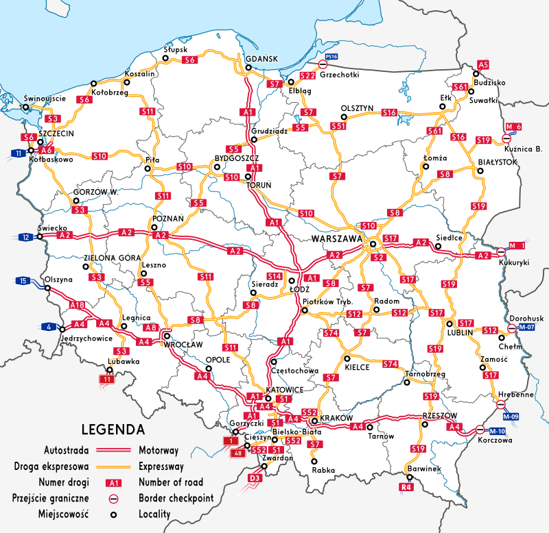
Cartographic symbols
In order for a map or a plan to fulfill its tasks, it must be made in such a way that everyone can read it properly. This is why maps and plans contain many different markings – we call them cartographic symbolscartographic symbols. They are used to present, on maps and plans, various objects and phenomena that exist in reality (e.g. location of a road) or that are conventional and result from various types of agreements (e.g. national borders). The meaning of these symbols is always described in the legendlegend.
Compass and map orientation
A magnetic compass is a device that indicates geographic directionsgeographic directions. We can use it to correctly orient a map. What does it mean? Imagine that you’re standing on a hill and looking around. You see fields, distant villages, roads and many other objects. If you want to find your location on the map, you need to position it so that the geographic directions on the map coincide with the geographic directions on land. To do so, you must place a compass on the map and wait for the needle to stop moving. Its red end will show you the north. Next, you position the map so that the north on the map aligns with the north indicated by the compass. The north on the map usually corresponds to the upper edge of the map, and if it is different, a compass rosecompass rose is included on the map. The map can also be oriented without the use of a compass, but with the use of field points. In a moment you will learn how to use this method.
Before you watch the movie „Map orientation”, write down the research question and the hypothesis. Make notes while watching the movie, and finally - conclusions.
Film dostępny na portalu epodreczniki.pl
Nagranie filmowe ukazuje mężczyznę idącego po wiadukcie, który dokonuje rozpoznanie w terenie, następnie wyjmuję mapę z torby i zaznacza punkt docelowy. W filmie za pomocą opisów wyjaśniono jak należy dokonać orientacji w terenie: How to find yourself in a new area and how to set a route to your chosen destination with the help of landmarks in the area? 1. Find the place where you are and which one you want to reach on the map.Then mark them with a pencil.- zbliżenie na mapę. 2. Find some characteristic points in the field and on the map.– zbliżenie na wybrane punkty na mapie oraz w terenie. 3. Specify their location on the map and in the field. Rotate the map until the directions of the terrain points coincide with those on the map.
GPS and how it works
Maps and plans are useful things for navigationnavigation, i.e., determining your position on Earth. A more modern method that allows us to determine our location and helps us travel outside is GPSGPS. A GPS receiver communicates with satellites that surround the Earth and establishes its position. If you move to a new place, the device will reconnect to the satellites. The receiver updates its position with great accuracy. In this way, subsequent measurements provide you with information about the direction and speed at which you are moving.
Match the pairs: English words with Polish definition.
działanie mające na celu precyzyjne ustalanie położenia oraz wyznaczanie kierunku przemieszczania się; wykorzystywana jest m.in. przez załogi statków, maszyn latających oraz w kosmonautyce, opis dołączony do mapy, w którym znajduje się m.in. wyjaśnienie występujących na niej znaków, graficzne przedstawienie kierunków świata na mapie lub kompasie, system nawigacji satelitarnej; skrót pochodzi od angielskiej nazwy systemu --- Global Positioning System, symbole, za pomocą których przedstawia się na mapie obiekty istniejące w rzeczywistości lub będące tylko efektem różnych ustaleń, kierunki pozwalające orientować swoje położenie na Ziemi; kierunek północny wskazuje północny biegun geograficzny Ziemi, południowy wskazuje biegun południowy, kierunek wschodni znajduje się na prawo od północy, a zachodni na lewo od niej
| GPS | |
| geographic directions | |
| legend | |
| navigation | |
| compass rose | |
| cartographic symbols |
Summary
Using a map or a plan, you can find your position outside and determine the direction in which you’re walking.
Objects on land are shown on plans and maps using cartographic symbols, which are explained in the map’s legend.
The compass is a device that shows geographic directions.
Keywords
cartographic symbols, orientation outside, Geocaching
Glossary
GPS – system nawigacji satelitarnej; skrót pochodzi od angielskiej nazwy systemu – Global Positioning System
kierunki świata – kierunki pozwalające orientować swoje położenie na Ziemi; kierunek północny wskazuje północny biegun geograficzny Ziemi, południowy wskazuje biegun południowy, kierunek wschodni znajduje się na prawo od północy, a zachodni na lewo od niej
legenda – opis dołączony do mapy, w którym znajduje się m.in. wyjaśnienie występujących na niej znaków
nawigacja – działanie mające na celu precyzyjne ustalanie położenia oraz wyznaczanie kierunku przemieszczania się; wykorzystywana jest m.in. przez załogi statków, maszyn latających oraz w kosmonautyce
róża wiatrów – graficzne przedstawienie kierunków świata na mapie lub kompasie
znaki kartograficzne – symbole, za pomocą których przedstawia się na mapie obiekty istniejące w rzeczywistości lub będące tylko efektem różnych ustaleń