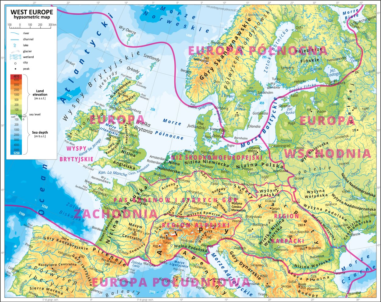
Western Europe is the most diverse physiographic region of Europe. It is divided into four main units – also called provinces. These are:
the archipelago of the British Isles on the continental shelf of Europe;
the North European Plain spreading from the North Sea down the middle section of the Vistula River;
a central range of old fault‑block mountain and uplands as well as vast lower terrains (the so‑called basins), spreading from the west coast of France to the Sudetes and the Polish Highlands;
young fold mountains – the Alps and the Carpathians with forelands and intermountain basins.
RAkl2NyURxZPN
Zdjęcie przedstawia mapę hipsometryczną Europy Zachodniej, West Europe hypsometric map. Oznaczone zostały rejony: Europa Północna, Europa Wschodnia, Europa Zachodnia, Europa Południowa. W obszarze Europy Zachodniej wyróżnione zostały Niż Środkowoeuropejski, Pas basenów i Starych Gór, Region Alpejski, Region Karpacki, Wyspy Brytyjskie.
The great physiographic regions (provinces) of Europe.
Source: tylko do użytku edukacyjnego na epodreczniki.pl, [online], dostępny w internecie: www.epodreczniki.pl.
Task 1
Wymień 5 stolic dowolnych krajów w Europie Zachodniej.
Wymień 5 stolic dowolnych krajów w Europie Zachodniej.
Take a look at the gallery and answer the question below.
R1bdJwF6MdrUI
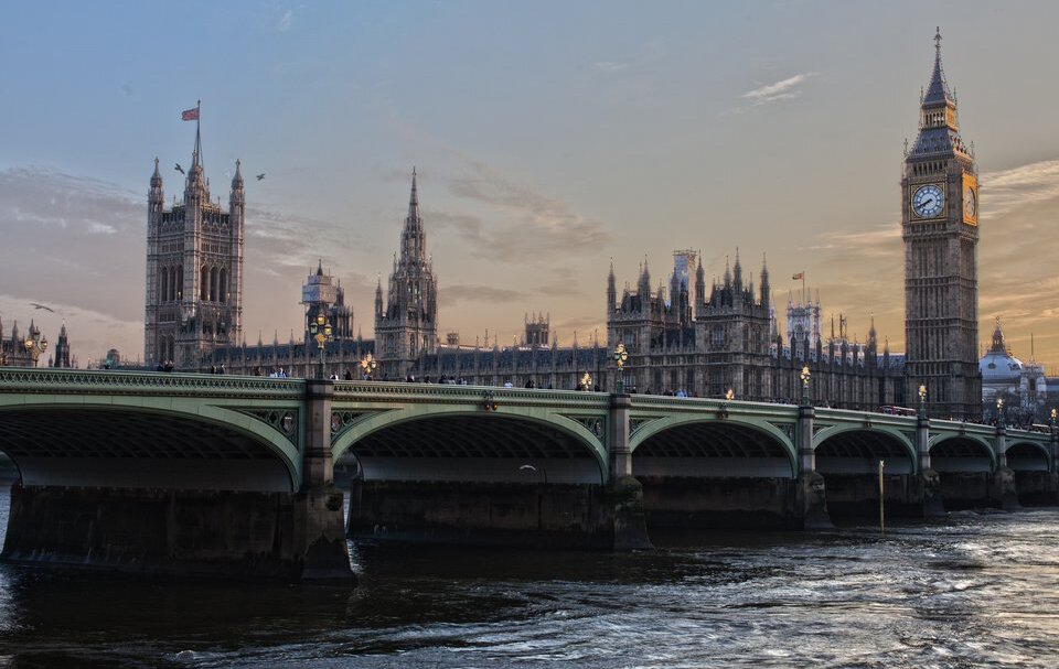
Zdjęcie przedstawia parlament Brytyjski o zachodzie słońca, budynek zakryty jest częściowo mostem. Widoczna po prawej stronie jest słynna wieża zegarowa, po przeciwnej stronie widoczna druga najwyższa z powiewającą flagą Union Jack.
Palace of Westminster
Source: licencja: CC 0, [online], dostępny w internecie: www.pixabay.com.
Rwq600OqIoL8q
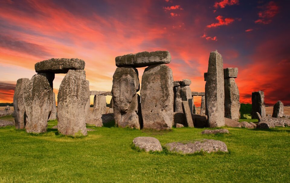
Fotografia przedstawia Stonehenge. Wielkie kamienie ułożone pionowo z poprzecznymi znacznie mniejszymi elementami. Wszystkie owe struktury są ułożone w koncentryczne kręgi, z których część rozpadła się już i porosła częściowo trawą.
Stonehenge
Source: licencja: CC 0, [online], dostępny w internecie: www.pixabay.com.
RJWbWks1qsIHj
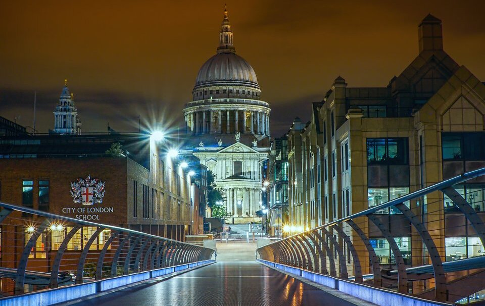
Fotografia przedstawia most milenijny u dołu, z którego zostało zrobione zdjęcie. W centrum widać katedrę świętego Pawła. Wysoka budowla jest zbudowana z jasnego kamienia, zakończona kopułą, na której widać mniejszą wierzę.
St Paul's Cathedral
Source: licencja: CC 0, [online], dostępny w internecie: www.pixabay.com.
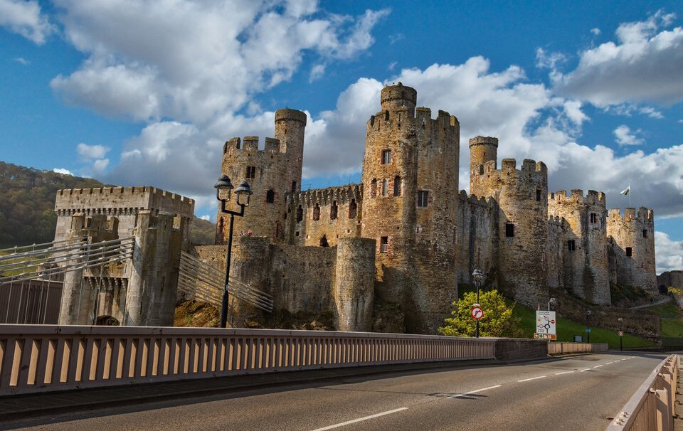
R2Hu0sWSgLdMf
Zdjęcie przedstawia zamek Cowny, wiele okrągłych niewysokich wierz ustawionych jest dookoła prostokątnego zamku.
Conwy Castle
Source: licencja: CC 0, [online], dostępny w internecie: www.pixabay.com.
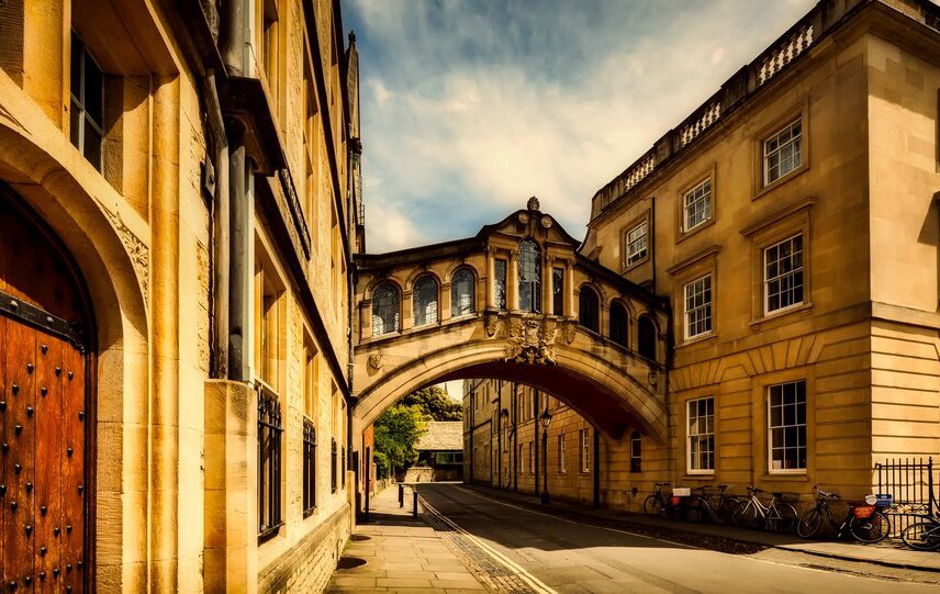
R1Lyx26wASRVC
Zdjęcie przedstawia most westchnięć łączący dwa budynki, uniesiony jest nad niewielką ulicą. Jest to krótki most zbudowany na łuku, każde z wielu okien otoczone jest niewielkimi kolumienkami.
Bridge of Sighs
Source: licencja: CC 0, [online], dostępny w internecie: www.pixabay.com.
Exercise 1
RKcbBjBgpJrSu
Wybierz jedno nowe słowo poznane podczas dzisiejszej lekcji i ułóż z nim zdanie.
Wybierz jedno nowe słowo poznane podczas dzisiejszej lekcji i ułóż z nim zdanie.
Task 2
Form four groups. Every group should choose and brainstorm one of the topics listed below.
Form four groups. Every group should choose and brainstorm one of the topics listed below.
Form four groups. Every group should choose and brainstorm one of the topics listed below. Write your conclusions in the space provided below.
R1bxbBUo1kzIR
Wykonaj polecenie.
Wykonaj polecenie.
Task 3
Use what you have learnt to complete the exercises below.
Exercise 2
RJ4JyPywyqsUE
Wybierz jedno nowe słowo poznane podczas dzisiejszej lekcji i ułóż z nim zdanie.
Wybierz jedno nowe słowo poznane podczas dzisiejszej lekcji i ułóż z nim zdanie.
RT5cCK2GEzfDD
Exercise 3
Własnymi słowami zdefiniuj wybrane terminy ze słownika.
Własnymi słowami zdefiniuj wybrane terminy ze słownika.
Mark the region of Western Europe which appears in the image.
North European Plain
Alpine Mountain System
British Isles
Central Uplands
Exercise 4
RZMaXemJA5hvY
Wymień największe porty morza Północnego.
Wymień największe porty morza Północnego.
Select the column with the correct answers. The largest ports of the North Sea are:
Rotterdam London Antwerp Bremen Hamburg
□
Rotterdam London Trondheim Antwerp Narvik
□
London Hamburg Gdynia Rotterdam Trondheim
□
Exercise 5
R65nABd4EXT7p
Wybierz jedno zagadnienie opisane w abstrakcie. Poszerz swoją wiedzę na jego temat, szukając dodatkowych informacji w dostępnych ci źródłach (np. w internecie, encyklopedii lub specjalistycznych publikacjach).
Wybierz jedno zagadnienie opisane w abstrakcie. Poszerz swoją wiedzę na jego temat, szukając dodatkowych informacji w dostępnych ci źródłach (np. w internecie, encyklopedii lub specjalistycznych publikacjach).
Mark with red those rivers that empty directly into the Atlantic Ocean, with green – those that empty into the North Sea, with purple – those that empty into the Baltic Sea, and with yellow – those that empty into the Black Sea.
Match the correct pairs. Sudetes Możliwe odpowiedzi: 1. The highest peak of this range is Mont Blanc., 2. The highest peak of this range is Feldberg., 3. The highest peak of this range is Punta Penia., 4. The highest peak of this range is Sněžka., 5. The highest peak of this range is Signal de Botrange. Alps Możliwe odpowiedzi: 1. The highest peak of this range is Mont Blanc., 2. The highest peak of this range is Feldberg., 3. The highest peak of this range is Punta Penia., 4. The highest peak of this range is Sněžka., 5. The highest peak of this range is Signal de Botrange. Dolomites Możliwe odpowiedzi: 1. The highest peak of this range is Mont Blanc., 2. The highest peak of this range is Feldberg., 3. The highest peak of this range is Punta Penia., 4. The highest peak of this range is Sněžka., 5. The highest peak of this range is Signal de Botrange. Ardennes Możliwe odpowiedzi: 1. The highest peak of this range is Mont Blanc., 2. The highest peak of this range is Feldberg., 3. The highest peak of this range is Punta Penia., 4. The highest peak of this range is Sněžka., 5. The highest peak of this range is Signal de Botrange. Black Forest Możliwe odpowiedzi: 1. The highest peak of this range is Mont Blanc., 2. The highest peak of this range is Feldberg., 3. The highest peak of this range is Punta Penia., 4. The highest peak of this range is Sněžka., 5. The highest peak of this range is Signal de Botrange.
Match the correct pairs. Sudetes Możliwe odpowiedzi: 1. The highest peak of this range is Mont Blanc., 2. The highest peak of this range is Feldberg., 3. The highest peak of this range is Punta Penia., 4. The highest peak of this range is Sněžka., 5. The highest peak of this range is Signal de Botrange. Alps Możliwe odpowiedzi: 1. The highest peak of this range is Mont Blanc., 2. The highest peak of this range is Feldberg., 3. The highest peak of this range is Punta Penia., 4. The highest peak of this range is Sněžka., 5. The highest peak of this range is Signal de Botrange. Dolomites Możliwe odpowiedzi: 1. The highest peak of this range is Mont Blanc., 2. The highest peak of this range is Feldberg., 3. The highest peak of this range is Punta Penia., 4. The highest peak of this range is Sněžka., 5. The highest peak of this range is Signal de Botrange. Ardennes Możliwe odpowiedzi: 1. The highest peak of this range is Mont Blanc., 2. The highest peak of this range is Feldberg., 3. The highest peak of this range is Punta Penia., 4. The highest peak of this range is Sněžka., 5. The highest peak of this range is Signal de Botrange. Black Forest Możliwe odpowiedzi: 1. The highest peak of this range is Mont Blanc., 2. The highest peak of this range is Feldberg., 3. The highest peak of this range is Punta Penia., 4. The highest peak of this range is Sněžka., 5. The highest peak of this range is Signal de Botrange.
Match the correct pairs.
The highest peak of this range is Signal de Botrange., The highest peak of this range is Punta Penia., The highest peak of this range is Mont Blanc., The highest peak of this range is Sněžka., The highest peak of this range is Feldberg.
Sudetes
Alps
Dolomites
Ardennes
Black Forest
1
Keywords
Western Europe, natural environment of Western Europe, fold mountains
potencjalna roślinność naturalna – wyraża hipotetyczny stan końcowego, granicznego stadium sukcesji roślinności na danym terenie, możliwy do osiągnięcia w momencie gdyby naturalne tendencje rozwojowe roślinności mogły się w pełni zrealizować w wyniku ustania antropopresji oraz naturalnych czynników destrukcyjnych.