In order to uniquely determine the location of any point on the globe, only two pieces of information is needed: which latitude through the selected point and on which meridian it is located. This information is geographical coordinates.
REjqDADeOUE8Q
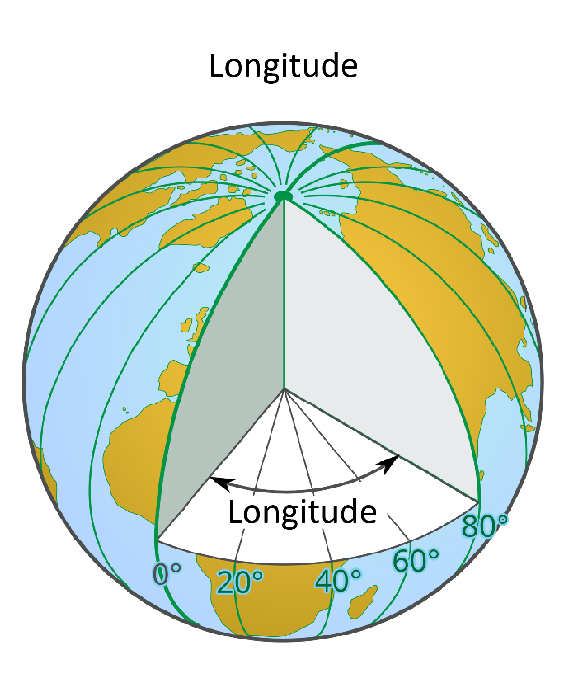
Ilustracja prezentuje definicje długości geograficznej, longitude. Na ilustracji kula ziemska, w której wycięto górną ćwiartkę i zaznaczono kąt dwuścienny między płaszczyzną biegnącego pionowo południka 0 stopni a płaszczyzną południka biegnącego pionowo i przechodzącego przez dany punkt, tutaj 80 stopni.
Longitude
Source: Andrzej Bogusz, licencja: CC BY 3.0.
R1SRgxUFL5TJc
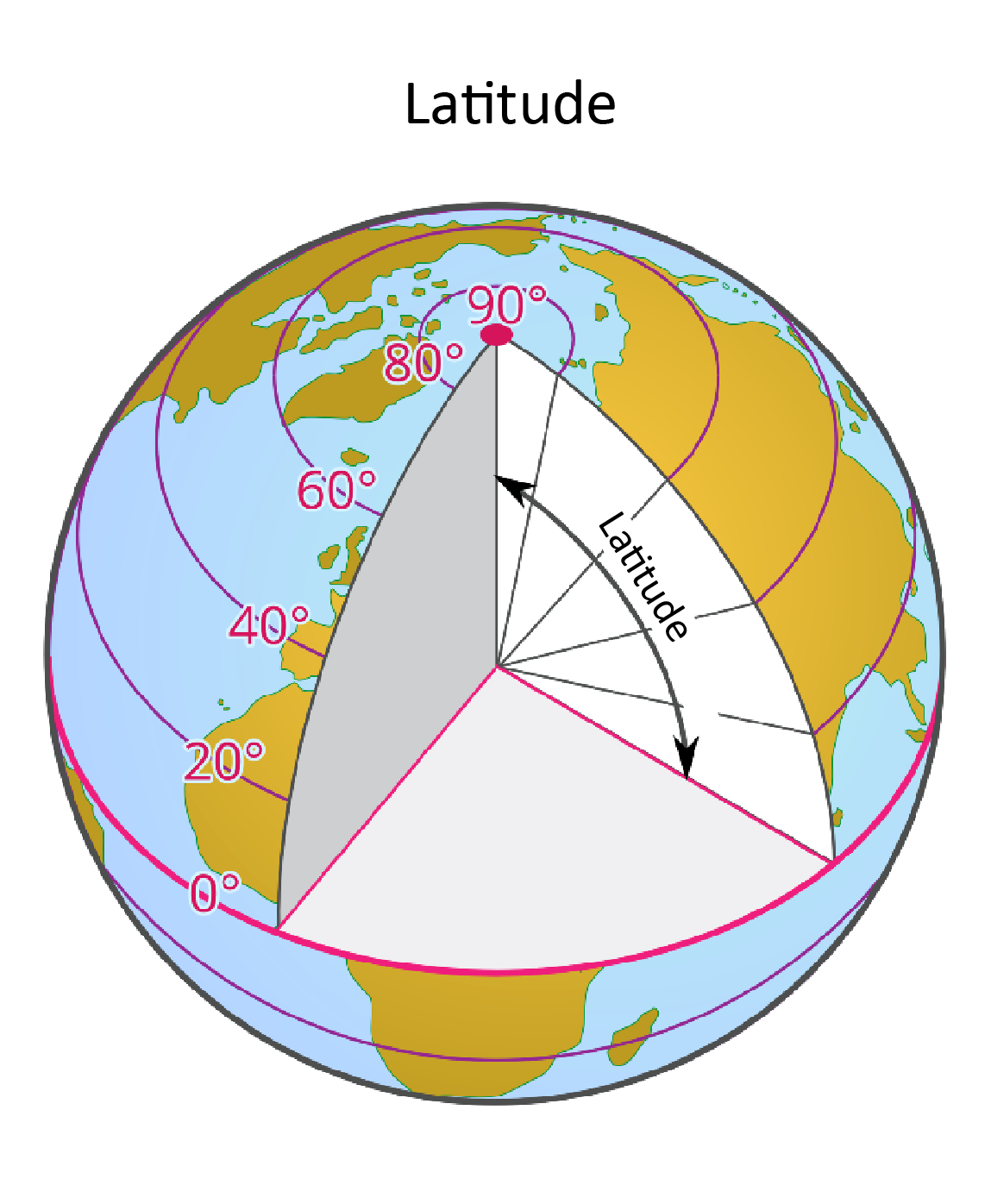
Ilustracja prezentuje definicję szerokości geograficzna, latitude. Na ilustracji kula ziemska, w której wycięto górną ćwiartkę i zaznaczono kąt między linią poziomą łączącą wybrany punkt ze środkiem Ziemi a płaszczyzną równika.
Latitude
Source: Andrzej Bogusz, licencja: CC BY 3.0.
The first coordinate is longitudelongitudelongitude, that is, the dihedral angle between the meridian plane of 0° and the plane of the meridian passing through the given point. We read the longitude by indicating which meridian passes through the selected point and adding information about the hemisphere on which it is located. Geographic lengths increase from 0° on the Greenwich meridian to 180°. Longitude is described as the meridians, that is, moving east from the meridian of 0° to each value, we add the eastern hemisphere (East) or E, and moving westward from Greenwich we mark the next meridians as lying in the western hemisphere (towards the west ) or W. On the 180° meridian, we do not add direction because it lies, like the 0° meridian, at the border between the two hemispheres.
The second coordinate is latitudelatitudelatitude, ie. the angle between the line connecting the selected point with the center of the Earth and the equator plane. We can read latitude by specifying the value of the parallel passing through the selected point and on which hemisphere it is located. If in the north, at the number indicating the latitude, add N, and if in the south, then S. The equator has a latitude 0°, the north pole – 90°N, and the south pole – 90°S.
R1J3sUiQL2rh9
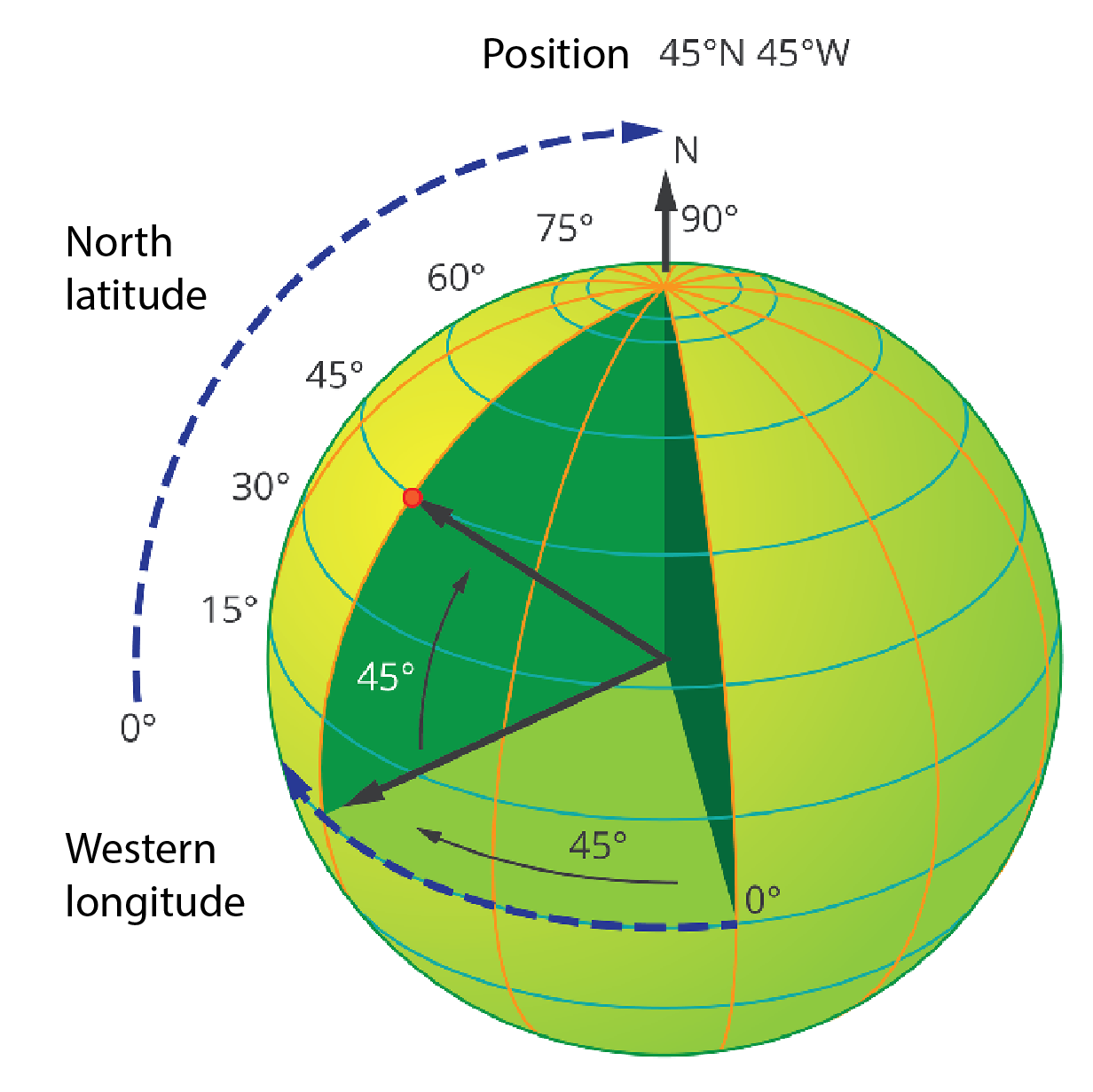
Ilustracja prezentuje sposób odczytu współrzędnych geograficznych. Szerokości geograficzne, latitude, odczytujemy, podążając po przerywanej linii pionowej od 0 stopni do 90 stopni. Długość geograficzną, longitude, odczytujemy podążając po przerywanej linii poziomej na równiku od 0 stopni do 180 stopni.
Geographical coordinates
Source: Andrzej Bogusz, Dariusz Adryan, licencja: CC BY 3.0.
Important!
Geographical coordinates (both latitude and longitude) are measured in degrees. One degree (1°) is divided into sixty minutes (60'), and every minute for sixty seconds (60'').
Task 1
Wyjaśnij, w jaki sposób można wykorzystać w codziennym życiu zawarte w abstrakcie informacje.
Wyjaśnij, w jaki sposób można wykorzystać w codziennym życiu zawarte w abstrakcie informacje.
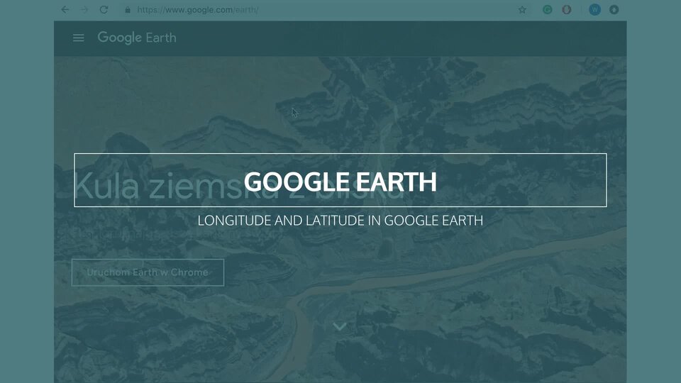
Watch the movie „Longitude and latitude in Google Earth” and answer the question (use Google Earth, information in the lower right corner of the screen).
RMyKPd89ABlGX
Nagranie filmowe "Longitude and latitude in Google Earth" dotyczące poruszania się po mapie Google Earth w formie nagrania ekranu komputera. Na początku widok przeglądarki internetowej Google Chrome i przejście na stronę earth.google.com. Widoczna strona startowa oraz przycisk Uruchom Earth w Chrome. Kursor klika przycisk. Pojawia się ekran ładowania, a następnie widok komputerowo wygenerowanej kuli ziemskiej w kosmosie. Kursor klika na kulę i obraca ją ze wschodu na zachód. Następnie kursor klika ikonę lupy, znajdującą się na pasku narzędzi po lewej stornie. Wyświetla się okno wyszukiwarki. Do wyszukiwarki wpisane zostają następujące szerokości geograficzne: 48°51'12"N 2°20'55"E. Następnie kliknięta zostaje ikona lupy i wyświetlona zostaje animacja zbliżania się do punktu zaznaczonego pinezką na kuli ziemskiej. Obraz zbliżył się do jednej z dzielnic Paryża. Widoczne są miniaturowe makiety budynków w 3D. Kursor myszy klika na obraz i zmienia perspektywę widoku na budynki. Następnie kliknięta zostaje ikona linijki, znajdująca się na pasku narzędzi po lewej stronie ekranu. W prawym górnym rogu wyświetla się okienko z dopiskiem Odległość. Kursor klika na miejsce na trójwymiarowej mapie. W miejscu kliknięcia pojawia się żółty punkt z białum środkiem. Kurso przesuwa się w inne miejsce, a między nim a punktem pojawia się żółta linia. Pod kursorem pojawia się żółta etykieta z wyświetloną odległością rzeczywistą – 337,49 m. Kursor zatacza koło przy okienktu z dopiskiem Odległość, gdzie pojawiła się wartość 337,49 m, następnie klika przycisk gotowe, a odcinek z odległością oraz okno znikają. Następnie kursor klika ikonę celownika, znajdującą się w prawym dolnym rogu ekranu. Pojawia się okno z zapytaniem o pozwolenie na lokalizację urządzenia. Kursor klika przycisk zezwól. Na ekranie wyświetla się animacja oddalenia, a następnie zbliżenia na jedną z dzielnic Wrocławia. Na ekranie pokazane jest zbliżenie na wartości szerokości geograficznych wyświetlanych w prawym dolnym rogu ekranu.
Nagranie filmowe "Longitude and latitude in Google Earth" dotyczące poruszania się po mapie Google Earth w formie nagrania ekranu komputera. Na początku widok przeglądarki internetowej Google Chrome i przejście na stronę earth.google.com. Widoczna strona startowa oraz przycisk Uruchom Earth w Chrome. Kursor klika przycisk. Pojawia się ekran ładowania, a następnie widok komputerowo wygenerowanej kuli ziemskiej w kosmosie. Kursor klika na kulę i obraca ją ze wschodu na zachód. Następnie kursor klika ikonę lupy, znajdującą się na pasku narzędzi po lewej stornie. Wyświetla się okno wyszukiwarki. Do wyszukiwarki wpisane zostają następujące szerokości geograficzne: 48°51'12"N 2°20'55"E. Następnie kliknięta zostaje ikona lupy i wyświetlona zostaje animacja zbliżania się do punktu zaznaczonego pinezką na kuli ziemskiej. Obraz zbliżył się do jednej z dzielnic Paryża. Widoczne są miniaturowe makiety budynków w 3D. Kursor myszy klika na obraz i zmienia perspektywę widoku na budynki. Następnie kliknięta zostaje ikona linijki, znajdująca się na pasku narzędzi po lewej stronie ekranu. W prawym górnym rogu wyświetla się okienko z dopiskiem Odległość. Kursor klika na miejsce na trójwymiarowej mapie. W miejscu kliknięcia pojawia się żółty punkt z białum środkiem. Kurso przesuwa się w inne miejsce, a między nim a punktem pojawia się żółta linia. Pod kursorem pojawia się żółta etykieta z wyświetloną odległością rzeczywistą – 337,49 m. Kursor zatacza koło przy okienktu z dopiskiem Odległość, gdzie pojawiła się wartość 337,49 m, następnie klika przycisk gotowe, a odcinek z odległością oraz okno znikają. Następnie kursor klika ikonę celownika, znajdującą się w prawym dolnym rogu ekranu. Pojawia się okno z zapytaniem o pozwolenie na lokalizację urządzenia. Kursor klika przycisk zezwól. Na ekranie wyświetla się animacja oddalenia, a następnie zbliżenia na jedną z dzielnic Wrocławia. Na ekranie pokazane jest zbliżenie na wartości szerokości geograficznych wyświetlanych w prawym dolnym rogu ekranu.
Nagranie filmowe "Longitude and latitude in Google Earth" dotyczące poruszania się po mapie Google Earth w formie nagrania ekranu komputera. Na początku widok przeglądarki internetowej Google Chrome i przejście na stronę earth.google.com. Widoczna strona startowa oraz przycisk Uruchom Earth w Chrome. Kursor klika przycisk. Pojawia się ekran ładowania, a następnie widok komputerowo wygenerowanej kuli ziemskiej w kosmosie. Kursor klika na kulę i obraca ją ze wschodu na zachód. Następnie kursor klika ikonę lupy, znajdującą się na pasku narzędzi po lewej stornie. Wyświetla się okno wyszukiwarki. Do wyszukiwarki wpisane zostają następujące szerokości geograficzne: 48°51'12"N 2°20'55"E. Następnie kliknięta zostaje ikona lupy i wyświetlona zostaje animacja zbliżania się do punktu zaznaczonego pinezką na kuli ziemskiej. Obraz zbliżył się do jednej z dzielnic Paryża. Widoczne są miniaturowe makiety budynków w 3D. Kursor myszy klika na obraz i zmienia perspektywę widoku na budynki. Następnie kliknięta zostaje ikona linijki, znajdująca się na pasku narzędzi po lewej stronie ekranu. W prawym górnym rogu wyświetla się okienko z dopiskiem Odległość. Kursor klika na miejsce na trójwymiarowej mapie. W miejscu kliknięcia pojawia się żółty punkt z białum środkiem. Kurso przesuwa się w inne miejsce, a między nim a punktem pojawia się żółta linia. Pod kursorem pojawia się żółta etykieta z wyświetloną odległością rzeczywistą – 337,49 m. Kursor zatacza koło przy okienktu z dopiskiem Odległość, gdzie pojawiła się wartość 337,49 m, następnie klika przycisk gotowe, a odcinek z odległością oraz okno znikają. Następnie kursor klika ikonę celownika, znajdującą się w prawym dolnym rogu ekranu. Pojawia się okno z zapytaniem o pozwolenie na lokalizację urządzenia. Kursor klika przycisk zezwól. Na ekranie wyświetla się animacja oddalenia, a następnie zbliżenia na jedną z dzielnic Wrocławia. Na ekranie pokazane jest zbliżenie na wartości szerokości geograficznych wyświetlanych w prawym dolnym rogu ekranu.
RDpI9nHnyf2ih
Wysłuchaj nagrania abstraktu i zastanów się, czego jeszcze chciałbyś się dowiedzieć w związku z tematem lekcji.
Wysłuchaj nagrania abstraktu i zastanów się, czego jeszcze chciałbyś się dowiedzieć w związku z tematem lekcji.
Where exactly are you at the moment? What is longitude and latitude of your:
Reading geographic coordinates
The ability to use geographic coordinates allows you to accurately locate each point on the globe. Knowing the geographical coordinates, you can precisely indicate the point in the terrain that suits them. You can also do the opposite. Knowing a place on the map, you can specify both its coordinates.
Task 2
Wyjaśnij, w jaki sposób można wykorzystać w codziennym życiu zawarte w abstrakcie informacje.
Wyjaśnij, w jaki sposób można wykorzystać w codziennym życiu zawarte w abstrakcie informacje.
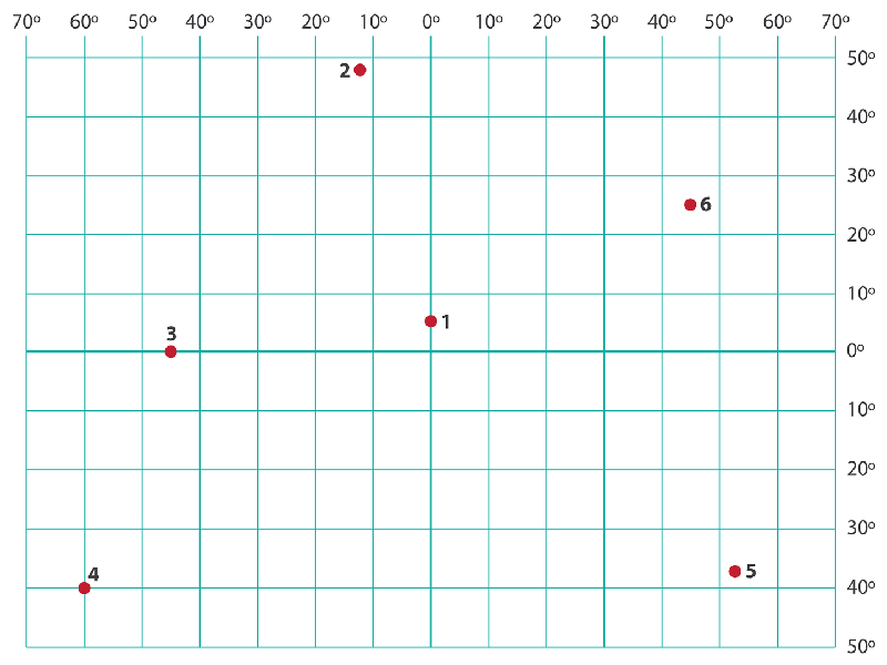
Using the „Exercises” graphic attached to the paragraph, write the coordinates of all 6 points on the card. Give the teacher a signed card.
R1GaeFLrnZqIM
Ułóż trzy pytania quizowe odnoszące się do abstraktu i daj je do rozwiązania swoim kolegom i koleżankom.
Exercises
Source: Dariusz Adryan, licencja: CC BY 3.0.
Important!
It should be remembered that most of the objects on the globe are of some size, occupying a surface. Therefore, many meridians and parallels pass through them. Specifying geographic coordinates almost always means some approximation, simplification.
GPS
GPSGPSGPS is an abbreviation of Global Positioning System, which can be translated as a global system for determining coordinates. It is the oldest, largest, most important and the most accessible satellite navigation system. GPS uses data from satellites circulating in Earth's orbit, which provide each user with very precise information about its location on the globe. Radio signals sent to the receiver by four satellites closest to the given place are taken into account. The measurement of the time that these signals require to reach the receiver is the basis for calculations to determine geographical coordinates.
GPS receivers are more and more often used in cars, where on the basis of the position determination they display the correct part of the road map and can provide information helpful in reaching the designated destination.
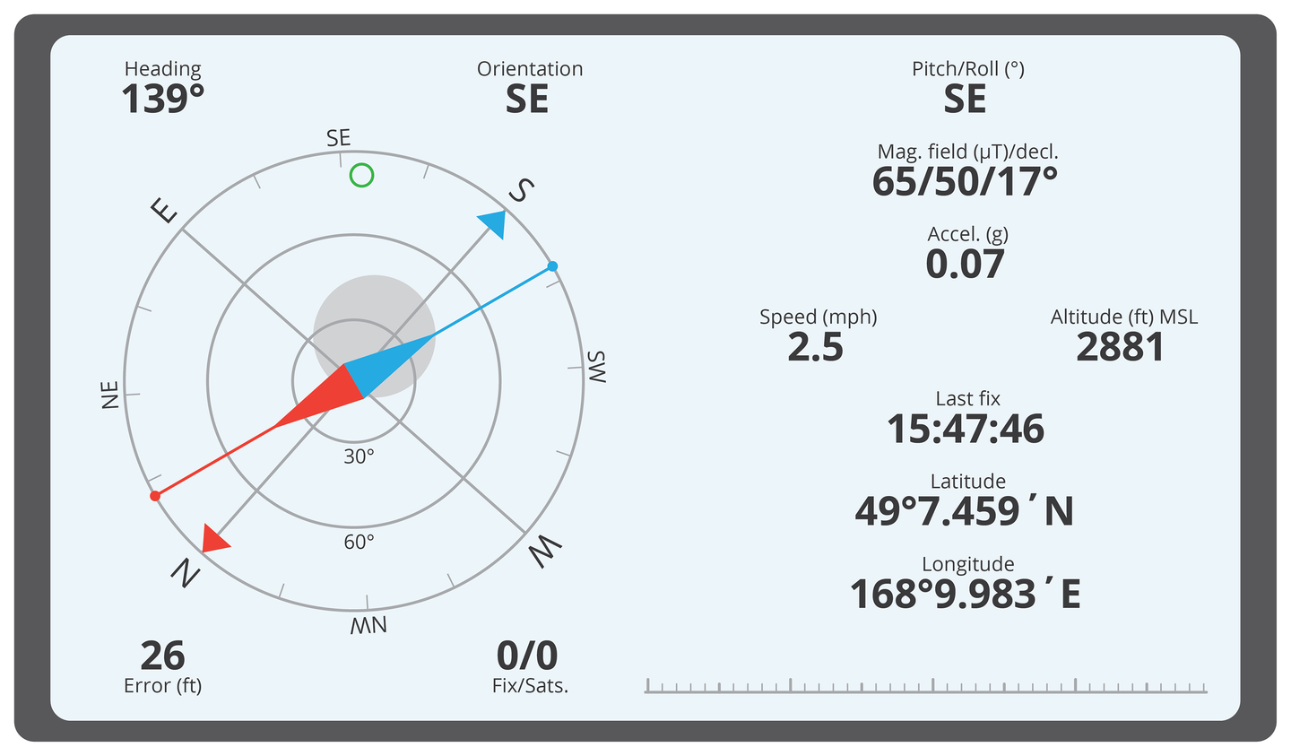
RP6avpQ3xGM3c
Ilustracja prezentuje ekran odbiornika GPS. Po lewej stronie widoczny kompas. Po prawej cyfry odczytu długości i szerokości geograficznej w stopniach oraz minutach.
Reading from the GPS
Source: Dariusz Adryan, licencja: CC BY 3.0.
Important!
Although GPS is created and maintained by the US Department of Defense, access to it is universal and free.
Warning!
The ability to use GPS should not completely replace the ability to use a map or the ability yo determine your geographical coordinates through observation of the Sun and stars. The technique can be unreliable. Satellites can be turned off (it is unlikely), you can lose or damage the GPS receiver (more likely) or the battery will run out (very likely).
R9W3q4wcBIpQB
Exercise 1
Wymyśl pytanie na kartkówkę związane z tematem abstraktu.
Wymyśl pytanie na kartkówkę związane z tematem abstraktu.
Source: GroMar Sp. z o.o., licencja: CC BY-SA 3.0.
RDS0AROL733z4
Exercise 2
Match the pairs: English words with Polish definition. longitude Możliwe odpowiedzi: 1. skrót od słów Global Positioning System, światowy system określania współrzędnych za pomocą nawigacji satelitarnej., 2. kąt dwuścienny między płaszczyzną południka 0 stopni a płaszczyzną południka przechodzącego przez dany punkt, 3. kąt między prostą przechodzącą przez środek Ziemi i wybrany punkt a płaszczyzną równika latitude Możliwe odpowiedzi: 1. skrót od słów Global Positioning System, światowy system określania współrzędnych za pomocą nawigacji satelitarnej., 2. kąt dwuścienny między płaszczyzną południka 0° a płaszczyzną południka przechodzącego przez dany punkt, 3. kąt między prostą przechodzącą przez środek Ziemi i wybrany punkt a płaszczyzną równika GPS Możliwe odpowiedzi: 1. skrót od słów Global Positioning System, światowy system określania współrzędnych za pomocą nawigacji satelitarnej., 2. kąt dwuścienny między płaszczyzną południka 0 stopni a płaszczyzną południka przechodzącego przez dany punkt, 3. kąt między prostą przechodzącą przez środek Ziemi i wybrany punkt a płaszczyzną równika
Match the pairs: English words with Polish definition. longitude Możliwe odpowiedzi: 1. skrót od słów Global Positioning System, światowy system określania współrzędnych za pomocą nawigacji satelitarnej., 2. kąt dwuścienny między płaszczyzną południka 0 stopni a płaszczyzną południka przechodzącego przez dany punkt, 3. kąt między prostą przechodzącą przez środek Ziemi i wybrany punkt a płaszczyzną równika latitude Możliwe odpowiedzi: 1. skrót od słów Global Positioning System, światowy system określania współrzędnych za pomocą nawigacji satelitarnej., 2. kąt dwuścienny między płaszczyzną południka 0° a płaszczyzną południka przechodzącego przez dany punkt, 3. kąt między prostą przechodzącą przez środek Ziemi i wybrany punkt a płaszczyzną równika GPS Możliwe odpowiedzi: 1. skrót od słów Global Positioning System, światowy system określania współrzędnych za pomocą nawigacji satelitarnej., 2. kąt dwuścienny między płaszczyzną południka 0 stopni a płaszczyzną południka przechodzącego przez dany punkt, 3. kąt między prostą przechodzącą przez środek Ziemi i wybrany punkt a płaszczyzną równika
Match the pairs: English words with Polish definition.
kąt dwuścienny między płaszczyzną południka 0° a płaszczyzną południka przechodzącego przez dany punkt, skrót od słów Global Positioning System, światowy system określania współrzędnych za pomocą nawigacji satelitarnej., kąt między prostą przechodzącą przez środek Ziemi i wybrany punkt a płaszczyzną równika
longitude
latitude
GPS
Summary
Knowing the point on the map, you can determine its geographical coordinates.
Knowing the geographical coordinates, you can indicate the appropriate point on the map.
A modern and accurate tool for determining geographical coordinates is GPS.
Car navigation is also based on GPS.
A smartphone, after installing the appropriate applications, also allows the use of GPS and maps for car navigation.