Position of the points on the map and on the globe
Położenie punktów na mapie oraz globusie
Learning objectives
You will discover the notion of the geographical coordinates.
Learning effect
You identify the geographical coordinates of the cities on the map and on the globe.
You recognize selected cities on the map according to their geographical coordinates.
You describe the position of the points on the map and on the globe in English.
Prepare for the lesson:
the atlases containing the mapmap of Poland,
the globes.
Revise the information about the coordinate system.
Answer the following question:
How can we identify the position of the point in the coordinate system?
Today you are going to discover the notion of the geographical coordinatesgeographical coordinates. You are also going to specify the position of the points on the mapmap and on the globeglobe.
Answer the following questions:
What is the map used for?
What is the globe used for?
Specifying the position of points on the map and on the globeglobe is similar to specifying the points in the coordinate system.
Open the atlas and analyse the cartographic grid which covers the mapmap of Poland, in particular pay attention to the lines of the grid and the method of its description. Use the Internet to search for the terms you don’t know (e.g. the meridians, the parallel arcs).
As the result of your considerations you should come up with the following conclusions:
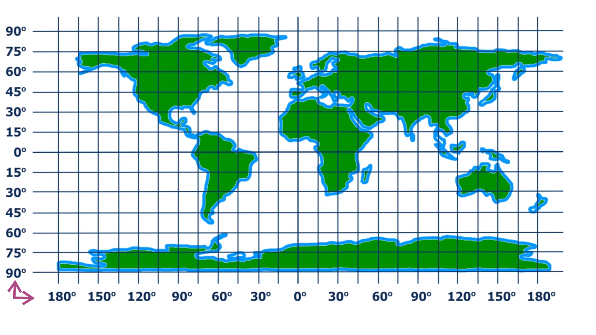
1. There are vertical and horizontal lines on the map that intersect at the right angle.{audio}
2. The vertical lines are called the meridians , the horizontal lines are called the parallel arcs.{audio}
3. On the border of the map there are written the values of the meridians and the parallel arcs measured in degrees.{audio}
The position of the point on the map is determined by the geographical coordinatesgeographical coordinates: the value of the parallel arcparallel arc (the latitude) and the value of the meridianmeridian (the longitude). The geographical coordinates are measured in degrees. One degree is divided into 60 minutes.
Using the map answer the following questions:
What parallel arcs run via Poland?
What hemispherehemisphere Northern or Southern is Poland situated in?
What meridians run via Poland?
Which hemisphere Eastern or Western is Poland situated in?
Notice, that:
The parallel arcs 50°, 51°, 52°, 53° and 54° subsequently pass via Poland. Our country is situated in the Northern HemisphereHemisphere.
The meridians 15°, 16°, 17°, 18°, 19°, 20°, 21°, 22°, 23°, 24° subsequently pass via Poland. It is situated in the Eastern Hemisphere.
Read the geographical coordinatesgeographical coordinates of Tarnow, the city situated near Cracow.
Tarnow lies at the intersection of the meridianmeridian of 21° and the parallel arcparallel arc of 50°, so we write the geographical coordinates of Tarnow as:
21 degrees of east longitudeeast longitude (21°E) and 50 degrees of north latitudenorth latitude (50°N).
Read the geographical coordinates of specified cities. Round up the result to the whole degrees:
a) Lublin,
b) Warszawa,
c) Gdynia.
The geographical coordinates of the cities visited by the students during their school trip are presented below:
19°27'E 51°47'N
18°37'E 53°02'N
18°00'E 53°07'N
19°02'E 54°02'N
18°38'E 54°22'N
Describe the route of the trip giving the names of the cities.
Use the globeglobe.
a) Find the parallel arcparallel arc of 0° (the equator) and the meridianmeridian of 0° (the meridian of Greenwich).
b) Give an example of the country which lies entirely on the Northern and Eastern HemisphereHemisphere at the same time.
c) Give an example of the country which lies entirely on the Southern and Western Hemisphere at the same time.
d) Give the approximate values of the geographical coordinatesgeographical coordinates of Madrid, New York, Sydney.
Notice, that:
The border between the Northern and Southern Hemisphere is determined by the equator and the border between the Eastern and Western Hemisphere is determined by the meridian of 0°.
An extra task:
Choose the European country and plan a trip. Write down the names and the geographical coordinates of the visited countries. Use the atlas with the mapmap of the country you have chosen.
Remember:
The position of the point on the mapmap is determined by the geographical coordinatesgeographical coordinates: the value of the parallel arcparallel arc (the latitude) and the value of the meridianmeridian (the longitude). The geographical coordinates are measured in degrees.
The parallel arc of 0°, called the equator, determines the border between the Northern and Southern HemisphereHemisphere.
The meridian of 0°, called the meridian of Greenwich, determines the border between the Eastern and Western Hemisphere.
It is said that places which are situated on the Northern Hemisphere have the north latitudenorth latitude (N), and the ones situated on the Southern Hemisphere have the south latitudesouth latitude (S).
It is said that places which are situated on the Eastern Hemisphere have the east longitudeeast longitude (E), and the ones situated on the Western Hemisphere have the west longitudewest longitude (W).
Do the summarizing exercises.
Exercises
Evaluate which of the following methods will allow you to determine your position on the globe.
- With the aid of a compass I will find out what my position is on the globe.
- With the aid of a measuring tape, I can determine my position on Earth.
- The GPS receiver will determine my position on Earth.
- The cartographic grid on the map I will use when traveling will allow me to determine the position on the globe.
Look at the map of Europe and read the meridians and the parallel arcs of the following countries:
a) Spain,
b) Italy,
c) France,
d) Greece.
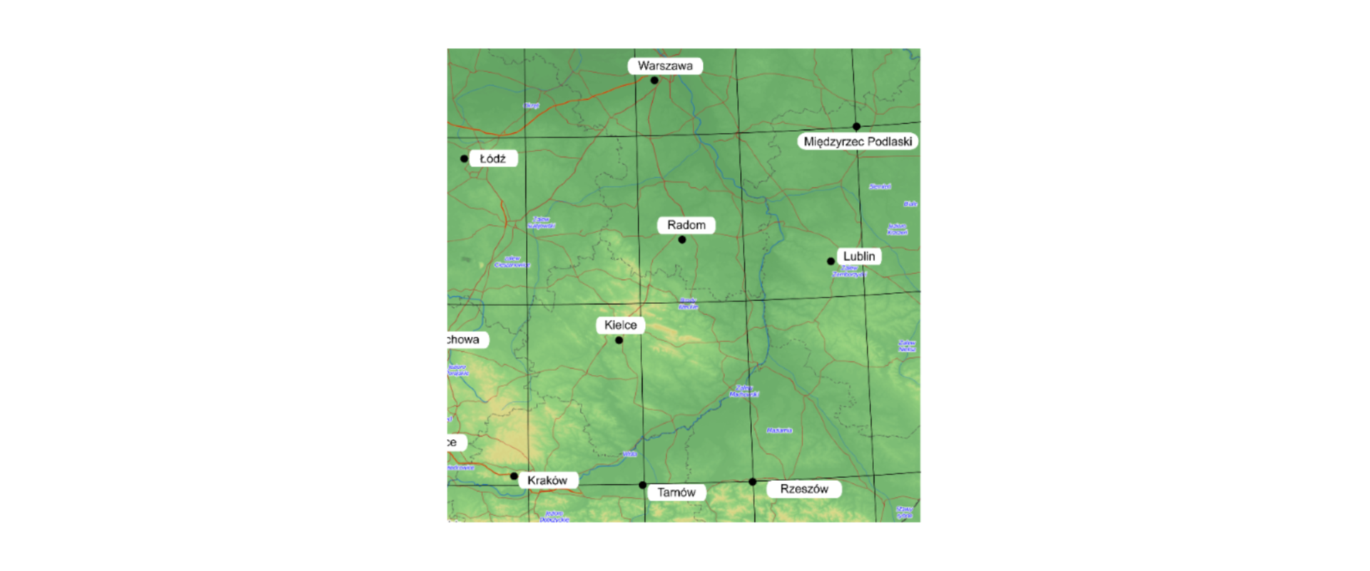
On the basis of the part of the map of Poland give the geographical coordinates of the following cities:
a) Rzeszów,
b) Międzyrzec Podlaski.
Describe the position of these cities in English.
Indicate which pairs of expressions or words are translated correctly.
- współrzędne geograficzne - geographical coordinates
- szerokość geograficzna północna - longitude
- szerokość geograficzna południowa - south latitude
- długość geograficzna wschodnia - latitude
- równoleżnik - parallel arc
- półkula - hemisphere
- długość geograficzna wschodnia
- szerokość geograficzna południowa
- south latitude
- geographical coordinates
- długość geograficzna zachodnia
- east longitude
- szerokość geograficzna północna
- west longitude
- współrzędne geograficzne
- north latitude
Glossary
współrzędne geograficzne
Nagranie dostępne na portalu epodreczniki.pl
wymowa w języku angielskim: geographical coordinates
szerokość geograficzna południowa
Nagranie dostępne na portalu epodreczniki.pl
wymowa w języku angielskim: south latitude
szerokość geograficzna północna
Nagranie dostępne na portalu epodreczniki.pl
wymowa w języku angielskim: north latitude
długość geograficzna wschodnia
długość geograficzna zachodnia
Nagranie dostępne na portalu epodreczniki.pl
wymowa w języku angielskim: west longitude
równoleżnik
Nagranie dostępne na portalu epodreczniki.pl
wymowa w języku angielskim: parallel arc
południk
Nagranie dostępne na portalu epodreczniki.pl
wymowa w języku angielskim: meridian
półkula
Nagranie dostępne na portalu epodreczniki.pl
wymowa w języku angielskim: hemisphere
mapa
Nagranie dostępne na portalu epodreczniki.pl
wymowa w języku angielskim: map
globus
Nagranie dostępne na portalu epodreczniki.pl
wymowa w języku angielskim: globe
Keywords
geographical coordinatesgeographical coordinates
north latitudenorth latitude
south latitudesouth latitude
east longitudeeast longitude
west longitudewest longitude