Geographical coordinates
that Earth is not a perfect sphere, it has the shape of a geoid – a solid that has no equivalent in geometry;
that Earth’s rotation occurs around its axis;
that the equatorial plane is tilted at a 23°27’ angle in relation to the plane on which the Earth orbits the Sun.
discuss the features of meridians and parallels;
determine the geographical location of various points and objects on the globe;
orientate geographic objects based on given geographic coordinates;
use the GPS system locating cities.
On the surface of the sphere, which is Earth, there are no reference points. Without introducing additional markings, you cannot determine the location of a place on its surface. To prevent this, you need to use a geographic coordinate system. You will learn how to do it during this lesson.
What are meridians and parallels and what qualities do they have?
Earth rotates around its own axis from west to east. The axis of rotation intersects the surface of our planet in places called geographic poles – North and South. They became reference points that helped create a coordinate network enabling the location of any object on the globe. The conventional lines on the Earth's surface connecting the shortest route from the North to the South Pole are called meridiansmeridians. All meridians have the same length. For practical reasons, it was necessary to determine a prime meridian. As a result, each of the meridians could be described with the degrees of a dihedral angle contained between its plane and the plane of the prime meridian. In 1884, the prime meridian was defined as the one that runs through the Royal Observatory, Greenwich (now within London).
ParallelsParallels were designated by drawing conventional lines perpendicular to the meridians on the surface of the Earth. They are shaped like circles and are parallel to each other. The closer to the poles, the smaller the circles. The longest parallel is at an equal distance from both poles and was given the name equatorequator. It became a reference point for the remaining parallels. Each of the parallels is described by degrees of the angle contained between the equator plane and Earth's radius passing through a given parallel. The system of meridians and parallels along with the poles forms the so‑called geographical coordinatesgeographical coordinates on the globe.
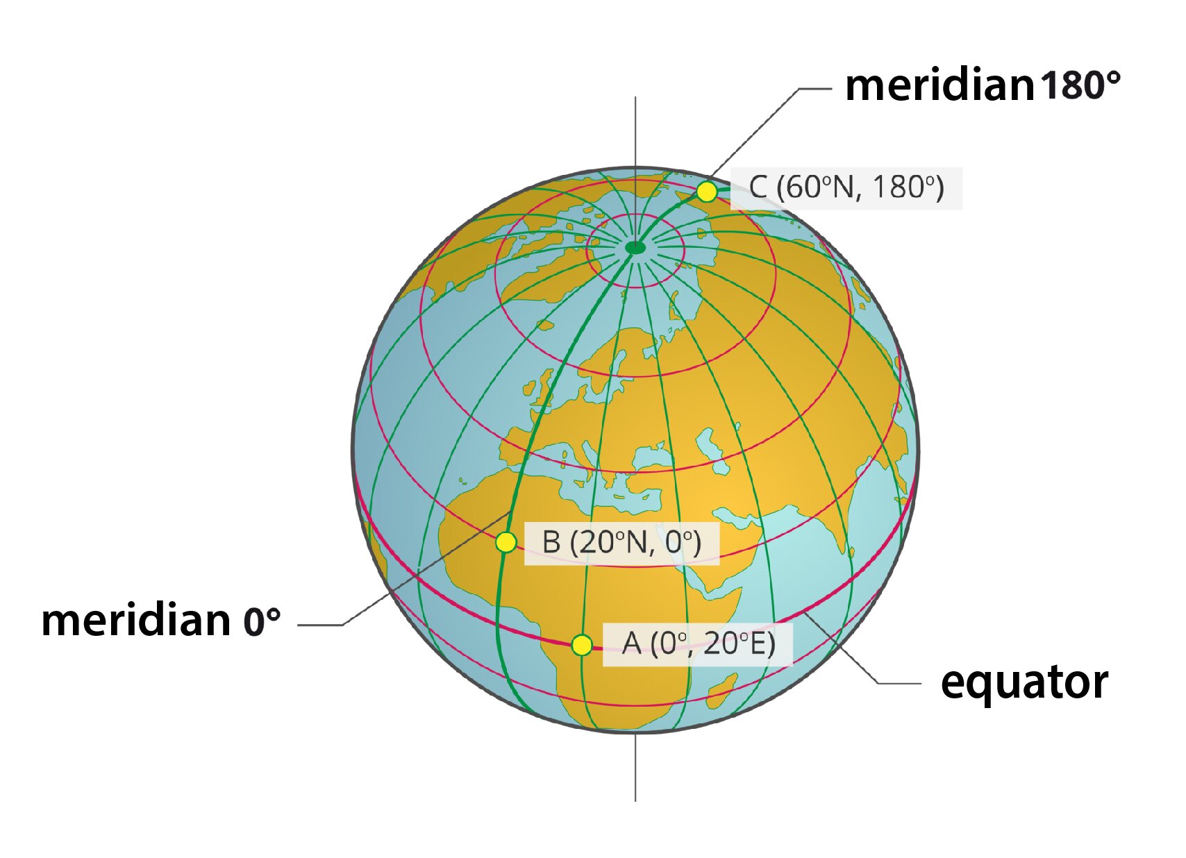
Characteristics of meridians:
they are shaped like semi‑circles;
they meet at the poles;
they have the same length (about 20,000 km);
a meridian can be carried through every point on Earth, that is why there are infinitely many of them;
they show directions: north and south;
conventionally designated meridians at 0° and 180° divide Earth into the Eastern and Western Hemispheres.
Characteristics of parallels:
they are shaped like circles;
the closer to the poles, the smaller the circles.
the longest parallel is the equator (about 40,000 km) that divides Earth into the Northern and Southern Hemispheres;
a parallel can be carried through every point on Earth, that is why there are infinitely many of them;
they intersect with the meridians at right angles and show the directions of east and west.
Using the knowledge gained during classes, perform the following exercises.
Watch the video and perform the following exercise.
Film dostępny na portalu epodreczniki.pl
Nagranie filmowe przedstawiające animację lotu samolotu przez Paryż, Tokio i Nowy Jork.
Pair cities, in which the airplane landed, with their geographical coordinates.
40°43′N 74°00′W, 48°52′N 2°21′E, 35°41′N 139°46′E
| Tokyo | |
| New York | |
| Paris |
Name the grid visible in the picture.
- Geographic grid
- Cartographic grid
- Azimuth grid
- Kirchhoff grid
Match the place to the given geographical coordinates.
| 40° 26 'N, 3°41′W | Madrid |
| 59°54′N ,10°44′E | Oslo |
| 48° 13' N , 16° 22' E | Vienna |
| 55° 45' N , 37° 37' E | Moscow |
| 40° 42' N , 74° 00' W | New York |
By using a map, pair cities and their geographical coordinates.
38°53′N , 77°02′W, 38°43′N , 9°07′W, 55°45′N , 37°36′E, 30°03′N , 31°14′E, 35°41′N ,139°41′E
| Lisbon | |
| Washington | |
| Moscow | |
| Tokyo | |
| Cairo |
Arrange in order (from the closest to the farthest) the located cities in relation to Warsaw.
- Cairo
- Tokyo
- Washington
- Lisbon
- Moscow
Summary
The grid of meridians and parallels enables the precise location of each point on the Earth's surface.
We define the longitude in relation to the Greenwich meridian, which was chosen as the prime meridian (0°) from an infinite number of identical meridians.
Latitude is defined in relation to the equator, which is the longest parallel.
The longitudinal extent of a given area is determined by the extreme parallels between which this area is located. The latitudinal extent, on the other hand, determines the extreme meridians that limit a given area.
Keywords
geography, latitude, longitude
Glossary
długość geograficzna - kąt dwuścienny pomiędzy półpłaszczyzną południka 0° a półpłaszczyzną południka przechodzącego przez dany punkt na powierzchni Ziemi; każda z półpłaszczyzn ograniczona jest osią ziemską
Koło podbiegunowe - jeden z równoleżników ziemskich o szerokości geograficznej 66°33'S; wielkość ta ulega ciągłej i powolnej zmianie; na południe od tego równoleżnika występuje zjawisko nocy polarnej; w pobliżu równoleżnika zjawisko to ma miejsce ok. 22 czerwca; im bardziej na południe, tym dłużej trwa, a na biegunie południowym trwa aż pół roku: od ok. 21 marca do ok. 23 września; zjawisko dnia polarnego obserwujemy natomiast w sąsiedztwie koła podbiegunowego południowego ok. 22 grudnia, a na biegunie od ok. 23 września do ok. 21 marca
Północne koło podbiegunowe - jeden z równoleżników o szerokości geograficznej 66°33'N; wielkość ta ulega ciągłej i powolnej zmianie; na północ od tego równoleżnika występuje zjawisko nocy polarnej; w pobliżu równoleżnika zjawisko to ma miejsce ok. 22 grudnia; im bardziej na północ, tym dłużej trwa, a na biegunie północnym trwa aż pół roku: od ok. 23 września do ok. 21 marca; zjawisko dnia polarnego obserwujemy natomiast w sąsiedztwie koła podbiegunowego północnego ok. 22 czerwca, a na biegunie od ok. 21 marca do ok. 23 września
południk - umowna linia na powierzchni Ziemi, kształtem zbliżona do półokręgu, łącząca oba bieguny i przecinająca się pod kątem prostym ze wszystkimi równoleżnikami; długość każdego z południków wynosi w przybliżeniu 20 tys. km
Równik - najdłuższy z równoleżników; jego długość przekracza nieznacznie 40 tys. km
równoleżnik - okrąg powstały w miejscu przecięcia płaszczyzny prostopadłej do osi ziemskiej z powierzchnią Ziemi
siatka geograficzna - układ południków i równoleżników na kuli ziemskiej lub na globusie
szerokość geograficzna - kąt pomiędzy linią przechodzącą przez dany punkt i środek Ziemi (promień ziemski) a płaszczyzną równika
współrzędne geograficzne - szerokość i długość geograficzna podane w stopniach (°), minutach kątowych (') i sekundach kątowych (''); jeden stopień to 60 minut kątowych, a minuta kątowa to 60 sekund kątowych
zwrotnik Koziorożca - jeden z równoleżników o szerokości geograficznej ok. 23°27'S; wielkość ta ulega ciągłej i powolnej zmianie; na zwrotniku tym 22 grudnia w południe Słońce świeci pod kątem 90°
zwrotnik Raka - jeden z równoleżników o szerokości geograficznej ok. 23°27'N; wielkość ta ulega ciągłej i powolnej zmianie; na zwrotniku tym 22 czerwca w południe Słońce świeci pod kątem 90°