Map scale, its types and calculation of distances
that the globe has been covered by a geographical grid thanks to which each point on its surface has its own individual coordinates;
that geographers have constructed many types of maps showing the whole of the Earth or its fragments;
that the map scale means the degree of reduction of the surface image of the Earth to present it on a plane.
what the map scale is and what it is for;
name the types of the scale;
calculate distances on the map and actual distances on different scales;
determine the dependence of the map content on the scale size;
explain why the actual image must be smaller.
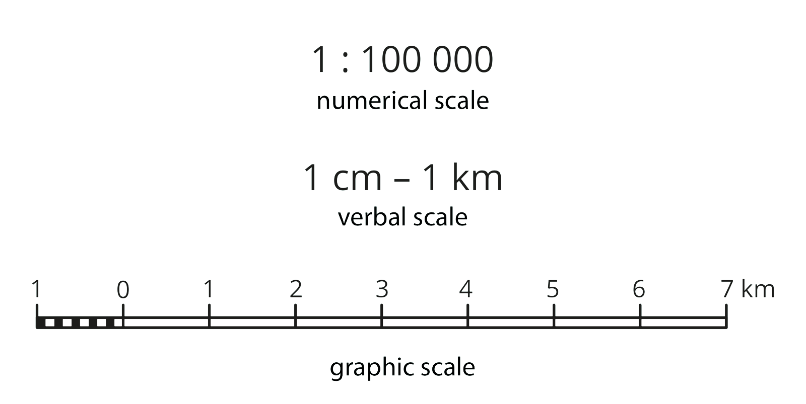
The presentation of any area on the mapmap requires its image to be reduced. The degree of such a reduction, i.e. the map scalemap scale, shows the ratio of the distance between two points on the map to the corresponding distance in the field. The horizontal distance in a straight line is taken into account, not the real distance, taking into account the terrain. This can be written down as follows:
Depending on the type of the notation, there are several types of scale. When we write it as a fraction, it is called the numerical scalenumerical scale. It may, for example, be in the form of 1:100000 or 1/100000. Sometimes, the second way of notation is called a fractional scale. In both cases, this scale informs that one section on the map corresponds to 100,000 identical sections in the field. The actual length of the section, which is 2 cm on the map with the above scale, is 2 x 100000 of the same two‑centimetre sections in the field, i.e. 200000 cm, 2000 m or 2 km. Thus, 1 cm on this scale corresponds to 100000 cm, 1000 m, or 1 km.
We can present it as: 1 cm – 1 km (or 1 cm → 1 km). The notation is read in the following way: one centimetre on the map corresponds to one kilometre in the field. Such a scale is called the expressed scaleexpressed scale.
Each scale can also be presented in a graphic form. We call it then the linear scalelinear scale.
In relation to maps made in appropriate scales, the terms small scale or the large scale are often used. It is easier to understand the differences between them when you remember that the scale is a fraction, so the higher the number in the denominator, the smaller the scale. Since the numerical value of scale 1:1000 is much greater than 1:100000000, it is easy to interpret that the first is large and the second is small.
If on a map drawn in the 1:75 000 scale we measured the path from home to school, and we obtained the result 4 cm, how long is the length of this road in the field?
If on a map with a scale of 1 cm – 250 m we measured the path from home to school, and we obtained the result 6 cm, how long is the length of this road in the field?
If we want to draw a map on a scale of 1:10 000, and we measured in the field the length of a football pitch, which is 110 meters, what length will this pitch have on the map?
The distance is 1500 meters. How many centimeters will it be on map with scale of 1: 100?
Types of maps
Due to the size of the scale, maps can be divided into three groups:
large‑scale maps (in scales larger than 1: 200 000, e.g. plans for building plots, city plans, topographic maps, tourist maps);
medium‑scale maps (from 1: 200 000 to 1: 1 000 000, e.g. car maps, overview maps, general geographical and thematic maps with larger scales);
small‑scale maps (scales smaller than 1: 1 000 000, e.g. overview maps, general geographical and thematic maps with smaller scales, continental maps, world maps).
What is the difference between small‑scale map and medium‑scale?
Put the numerical scales from the smallest to the largest in the correct order.
- 1: 150000
- 1: 2500000
- 1: 25000
- 1: 450000
- 1: 50000
- 1: 1800
Completing text individually.
The image of the Earth's surface is presented on the plane in an appropriate ................... The ratio of the distance on the map to the corresponding horizontal distance in the field is given by the ................... It shows how many times the actual distance has been .............. on the map. In relation to maps made in appropriate scales, the terms small scale or large scale are often used. The scale is a fraction, the greater the number in the denominator, the .............. the scale. Using the scale of 1cm - 1km we read that 1cm on the map is ............ in the field.
Combine the appropriate scale with the numerical scale.
1cm - 2000 km, 1cm - 20 km, 1 cm - 2 km, 1cm - 200 km, 1cm - 200 m
| 1: 200 000 | |
| 1: 20 000 000 | |
| 1: 2 000 000 | |
| 1: 200 000 000 | |
| 1: 20 000 |
Keywords
map scale, map, distance
Glossary
mapa – uproszczony obraz powierzchni Ziemi, innej planety lub ich części przedstawiony na płaszczyźnie w odpowiednio dobranej skali za pomocą umownych znaków i zgodnie z określonym odwzorowaniem kartograficznym
skala liczbowa – informuje, ile razy rzeczywiste rozmiary jakiegoś obiektu lub obszaru zostały pomniejszone lub powiększone; jeżeli obiekt pomniejszony jest 10 000 razy, to oznacza, że został odwzorowany w skali 1:10 000
skala mapy – stosunek wielkości liniowych rozmiarów fragmentu powierzchni, dla jakiego opracowano odwzorowanie kartograficzne danej mapy, do rzeczywistej wielkości tych rozmiarów
skala mianowana – skala mapy zapisywana jako porównanie dwóch odległości: pierwsza odległość to długość odcinka na mapie, a druga (wyrażona zazwyczaj w metrach lub kilometrach) to długość tego samego odcinka w terenie; przykład zapisu tej skali: 1 cm – 10 km, co oznacza, że odcinek o długości 1 cm na mapie odpowiada 10 km w terenie
skala liniowa – skala w postaci graficznej