Major geographic regions and population of the United States of America
that the United Stated is an economically developed country;
that the United States is an immigrant country founded mainly by immigrants from Europe and slaves brought from Africa;
that a region’s natural environment influences its economic development.
to show the great regions on a map of the United States;
to name the major population groups inhabiting the United States;
to name the reasons for the decline of the Native American culture.
Major geographic regions of the United States of America
The United States of America is the fourth largest country in the world, with a surface area of 9,526,5 thousand sq. km, and the third most populous one, with 322 million inhabitants in 2010. This vast country is made up of continental states that lie in the central part of the North American continent, between the 25th parallel north and the 49th parallel north. Two more states, Alaska in the northwest extremity of North America and Hawaii in the Pacific Ocean, are located outside the main part of the United States. One of the crucial features of the natural environment of the United States is the meridional layout of its major geographic regions, which differ in altitude above sea level and landscape. Terrain and climate variations influence also other aspects of the natural environment of each region. In the past, the natural boundaries of those regions created barriers to further settlement on the continent. Even today they have a significant effect on the economic development of certain areas.

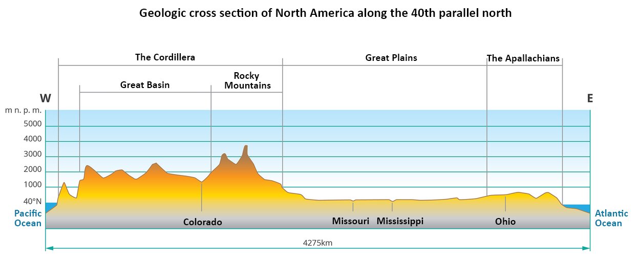
East and south coasts of the United States are covered by coastal plains: the Atlantic Plain with numerous lower sections of rivers, bays and marshlands in the east and the much broader Gulf Coastal Plain in the south. The central part of the Gulf Coastal Plain is where the growing Mississippi River Delta lies. The Atlantic Plain is bordered to the west by the Appalachians – fold mountains with glacial landforms in the northern part. The section going through the United States is about 2300 km long. The highest peak of the Appalachians is Mount Mitchell, located in the southern part of the range. Its elevation is 2037 m a.s.l.
To the west of the Appalachians there are Inner Plains also known as Central Plains. In the northern part of the region there are 5 Great Lakes, which are the largest freshwater reservoir in the world. In the middle part there is a karst carving with numerous caves. The northern part of the region was glaciated up to the valleys of the Ohio and Missouri rivers, the tributaries of the Mississippi River, which drains waters from this region to the Gulf of Mexico. Moving west, we encounter the Great Plains, also called Plains, stretching from the border with Canada to the border with Mexico. The terrain rises here gently to the base of the Rocky Mountains. It is dissected by numerous deep river valleys with a latitudinal course whose rivers drain water to Missouri and Mississippi. The western part of the country is occupied by the young Cordillera Mountains. To the east are the Rocky Mountains, and to the west along the Pacific there is a band formed by the Coastal Mountains, Cascade Mountains and Sierra Nevada. Between them there are plateaus and basins: the Colombian Upland, the Great Basin and the Colorado Plateau. The Cordilleras belt in the west of the USA is about 1700 km wide. The peaks of the Rocky Mountains and other bands reach over 4,000. m.a.s.l. Whitney's highest peak (4418 m above sea level) is located in the Sierra Nevada.
The territory of the United States lies in 4 different climate zones:
the north coast of Alaska is characterised by a polar climate, whereas its central part is dominated by a subarctic climate and the south coast by a cool temperate climate;
the latitudinal strip of land along the Canadian border is characterised by a warm temperate climate;
further to the south, the belt stretching from the Pacific Mountains to the Atlantic Plain lies subtropical climate zone;
the Hawaiian Islands, the Florida peninsula and the southern parts of the Gulf Coastal Plain are located in the tropical climate zone.
Population of the United States of America
The United States of America is the largest immigrant country in the world. People coming to live there originated from diverse national and ethnic backgrounds. Currently the US is inhabited by 322 million people, which makes for 4.4% of the world’s population.
The population of the United States is constantly growing, which sets it apart from other developed countries of the world. This growth is achieved thanks to a relatively high rate of natural infcrease and positive net migration. In recent years, about 1.2 million people have come to the US per year. The estimated number of illegal immigrants is 250 thousand.
Nowadays, the population of United States is composed of several large groups:
White population – 66.9%;
LatinosLatinos, i.e. people having their origins in Latin America – 14,4% (officially known as the Hispanic population since 2000);
African Americans – 12.8%;
Asians and Pacific Islanders – 4,5%;
Indigenous Americans and the InuitInuit – 1,0%;
others – 0.4%; this group includes people of various ethnic backgrounds who do not identify with any of the above groups.
One tendency of the US population structure that has been observed for decades is the constant growth of population originating from Latin America. Due to its ethnic diversity, American society is known as multicultural.
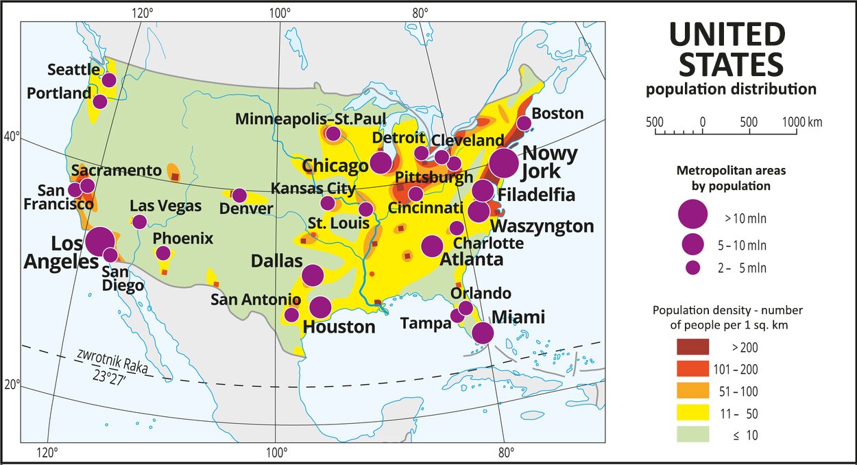
Nowadays, the urban population comprises about 81.6% of the entire population. Population density is significantly higher in the eastern and central parts of the country as well as on its western coast. The most sparsely populated areas are the Cordillera and the Great Plains.
In the United States there are 51 metropolitan areas and cities inhabited by more than 1 million people. The largest one is the New York–Northern New Jersey–Long Island metropolitan area with a population of 21 million. The second‑largest one is the metropolitan area of Los Angeles–Long Beach–Santa Ana inhabited by 14 million people and located on the West Coast.
The employment structure in the US is typical for an economically developed country.
Use what you have learnt to complete the exercises below.
Using data available on the internet complete the text with the correct words.
Guadalupe, second, emigrant, fourth, 48, immigrant, third, Indian, 50, Hawaii, Atlantic, third
The United States is the .................. largest country in the world. The mainland part of its territory consists of .................. continental states lying between the .................. Ocean and the Pacific Ocean, in central North America. Two more states – Alaska and .................. – are located outside that continuous area. The USA is the largest .................. country and the .................. most populous nation in the world.
Put the names of cities in the correct order, starting with the most populous one.
- Los Angeles
- Philadelphia
- Chicago
- Houston
- New York
Match the characteristic features to the United States regions.
old mountains characterised by glacial landforms, located in the north of the United States. They are approx. 2300 km long., the 5 great lakes located in the northern part of the region are the largest fresh water reservoir in the world. Its central part is characterised by a karst landscape with numerous caves., the growing Mississippi river delta is located in its central part, a vast area spreading from the Canadian border all the way down to Mexico. It is broken by numerous deep latitudinal valleys of rivers that flow into the Missouri and the Mississippi.
| Gulf Coastal Plain | |
| Appalachians | |
| Great Plains | |
| Interior Lowlands |
Summary
The United States of America has the fourth largest surface area of all countries in the world. The mainland part of its territory consists of 48 continental states lying between the Atlantic Ocean and the Pacific Ocean in the central part of North America. Two more states – Alaska and Hawaii – are located outside that continuous area.
The United States of America is the largest immigrant country in the world. People coming to live there originated from diverse national and ethnic backgrounds. It is now the third most populous country in the world.
Keywords
Inuit, Latinos, Gulf Coastal Plain
Glossary
Latynosi - określenie narodów zamieszkujących Amerykę Łacińską i ich potomków na całym świecie. Termin Latynos odnosi się raczej do stylu życia i specyficznej kultury niż do kategorii rasowych. Ludność pochodząca z Ameryki Łacińskiej – 14,4% .Od 2000 roku tę grupę ludności określa się jako Hispanies.
Inuici - grupa rdzennych ludów obszarów arktycznych i subarktycznych Grenlandii, Kanady, Alaski i Syberii.