E-resource GEOLOGY
Application of drilling tools and equipment during drilling
1. Film in the standard version.
Film dostępny na portalu epodreczniki.pl
The film presents a conversation between a drilling director and a field employee (a driller). They discuss the arrangements regarding the selection of drilling tools for the problems encountered during drilling. Film przedstawia rozmowę między kierownikiem do spraw wierceń, a pracownikiem terenowym (wiertnikiem). Wspólnie omawiają ustalenia dotyczące doboru narzędzi wiertniczych do problemów, które pojawiły się podczas wiercenia gruntów.
2. Film with subtitles.

Film dostępny na portalu epodreczniki.pl
The film presents a conversation between a drilling director and a field employee (a driller). They discuss the arrangements regarding the selection of drilling tools for the problems encountered during drilling. Film przedstawia rozmowę między kierownikiem do spraw wierceń, a pracownikiem terenowym (wiertnikiem). Wspólnie omawiają ustalenia dotyczące doboru narzędzi wiertniczych do problemów, które pojawiły się podczas wiercenia gruntów.
3. Film with subtitles and pauses. Listen and repeat after the speaker.

Film dostępny na portalu epodreczniki.pl
The film presents a conversation between a drilling director and a field employee (a driller). They discuss the arrangements regarding the selection of drilling tools for the problems encountered during drilling. Film przedstawia rozmowę między kierownikiem do spraw wierceń, a pracownikiem terenowym (wiertnikiem). Wspólnie omawiają ustalenia dotyczące doboru narzędzi wiertniczych do problemów, które pojawiły się podczas wiercenia gruntów.
4. Film with subtitles and narration.

Film dostępny na portalu epodreczniki.pl
The film presents a conversation between a drilling director and a field employee (a driller). They discuss the arrangements regarding the selection of drilling tools for the problems encountered during drilling. Film przedstawia rozmowę między kierownikiem do spraw wierceń, a pracownikiem terenowym (wiertnikiem). Wspólnie omawiają ustalenia dotyczące doboru narzędzi wiertniczych do problemów, które pojawiły się podczas wiercenia gruntów.
After watching the film “Application of drilling tools and equipment during drilling”, complete the sentences with the correct words/phrases. Use the word bank.
Po obejrzeniu filmu „Zastosowanie narzędzi wiertniczych i osprzętu podczas wierceń”, uzupełnij zdania odpowiednimi słowami/zwrotami. Skorzystaj z banku słów.
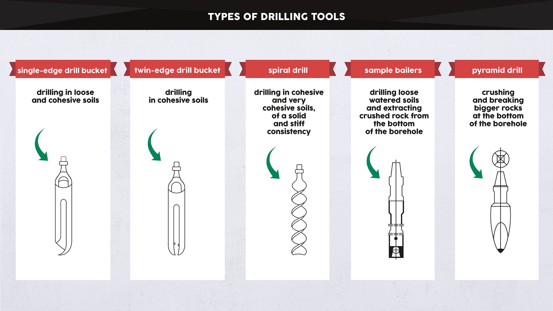
water-bearing levels, hard rock, water-bearing level, 72 hours, spiral drill, casing pipes, purification, single-edge drill bucket
Hydraulic connections of various ................................................ need to be closed.
We use a ................................................ to drill in loose soil.
We use a ................................................ to drill in cohesive soil.
A pyramid drill is used to crush .................................................
The filter needs to be placed within the .................................................
At the end of the drilling, the ................................................ are removed, starting from the smallest diameter.
Model measuring pumping takes .................................................
Before measuring pumping, you need to run ................................................ pumping.
After familiarizing yourself with the film “Application of drilling tools and equipment during drilling”, match the Polish words/phrases with their English equivalents.
Po zapoznaniu się z filmem „Zastosowanie narzędzi wiertniczych i osprzętu podczas wierceń”, połącz polskie słowa/zwroty z ich angielskimi odpowiednikami.
pyramid drill, subfilter pipe, casing pipes, ultrafilter pipe, filter, spiral drill, bailer, hydraulic connections, under balanced drilling, single-edge drill bucket
| połączenia hydrauliczne | |
| wiercenie bezpłuczkowe | |
| świder rurowy jednonożowy | |
| świder spiralny | |
| świder piramidalny | |
| szlamówka | |
| filtr | |
| rura podfiltrowa | |
| rura nadfiltowa | |
| rury osłonowe |
Collecting samples from a borehole

Film dostępny na portalu epodreczniki.pl
The animation presents methods of collecting soil and water samples during drilling, and their types. Materiał przedstawia metody pobierania prób gruntu i wody w trakcie wierceń, oraz ich rodzaje.
After watching the animation “Collecting samples from a borehole”, decide whether the sentences are true or false.
Po obejrzeniu animacji „Pobór prób z otworu wiertniczego”, zdecyduj, czy twierdzenia są prawdziwe, czy fałszywe.
| Prawda | Fałsz | |
| The collected samples are used for laboratory tests. | □ | □ |
| In engineering geology, we distinguish samples with a natural grain size and samples with natural humidity only. | □ | □ |
| Cohesive soils are collected for sieve analysis. | □ | □ |
| Cohesive soils are collected directly from drilling tools in order to establish the leading parameter, which is the plasticity index IL. | □ | □ |
| Soil samples are collected into plastic bags, jars or wooden geological boxes. | □ | □ |
| The collected water should be stored for three days before it is delivered to the laboratory. | □ | □ |
| Each sample label should contain information on: the subject of the carried out task, the place of sample collection and the depth of collection. | □ | □ |
| Water samples are collected from a stabilized groundwater table to a clean bottle of a volume of 1l. | □ | □ |
Geophysical methods of testing in boreholes

Film dostępny na portalu epodreczniki.pl
The animation presents the method of taking measurements using probes and parameters that can be obtained as a result of geophysical measurements: content of organic matter, mineral composition and porosity. Animacja przedstawia sposób wykonywania pomiarów za pomocą sond oraz parametry, które można uzyskać w wyniku pomiarów geofizycznych: zawartość materii organicznej, skład mineralny, porowatość.
Applying the geological and mining law during the liquidation of a borehole
The hypertext material presents a conversation between a client and a contractor of geological works. The conversation concerns the liquidation of a well.
Hipertekst przedstawia rozmowę klienta z wykonawcą robót geologicznych. Rozmowa dotyczy likwidacji studni.
Client: Good morning, I have an appointment to discuss the liquidation of my well. A water pipeline was laid in our town, and I won’t need the well anymore.
Contractor of geological works: Good morning. Please, have a seat.
Client: Time is of the essence to me. I want to build a garage there.
Contractor of geological works: Fortunately, this geological task is not very time‑consuming. The whole thing will take about six weeks.
Client: Why so long?
Contractor of geological works: The liquidation of a boreholeliquidation of a borehole should be carried out in accordance with the geological and mining law.geological and mining law. First, a geological work projectgeological work project for the liquidation of the borehole must be created.
Client: How long will it take?
Contractor of geological works: About a week, but we’ll have to wait about two more weeks for the approving decision.
Client: That’s not good.
Contractor of geological works: Later, we have to report the geological works,geological works, and after two more weeks we’ll begin filling in the borehole.
Client: And what will the work look like?
Contractor of geological works: The part that was once sand will be flooded with sand of the same fraction.fraction. Where there are cohesive soils, we’ll perform loaming.loaming.
Client: Will this be the end of the works?
Contractor of geological works: Unfortunately not. Other geological documentationOther geological documentation must be prepared for the completed works. And then just the water‑law reportwater‑law report from the liquidation of the water equipment.liquidation of the water equipment.
Client: I didn’t expect so much work. Those are additional costs for me.
Contractor of geological works: I’ll prepare the full price offer for tomorrow.
Client: I’m more interested in how the surface of the area will look. Won’t a depression be formed?
Contractor of geological works: Please, don’t worry. The section from 0 to 1m below the ground surface will be cemented.cemented.
Client: You’ve calmed me down. At the moment, money is my only worry.
Contractor of geological works: So we’ll try to prepare a special offer for you.
Client: I’d be grateful. In that case, see you later.
Contractor of geological works: We’ll arrange all the details tomorrow. Goodbye.
After familiarizing yourself with the hypertext “Applying the geological and mining law during the liquidation of a borehole”, put the dialogue in the correct order.
Po zapoznaniu się z hipertekstem „Zastosowanie prawa geologicznego i górniczego podczas likwidacji otworu”, ułóż dialog w odpowiedniej kolejności.
- How long will it take?
- First, a geological work project must be prepared.
- I didn’t expect so much work. Will it be expensive?
- Good morning. I have an appointment to discuss the liquidation of my well.
- I’ll prepare the full price offer for tomorrow.
- Will this be the end of the works?
- Why so long?
- Yes, I remember. Fortunately, this geological task is not very time-consuming. The whole thing will take about six weeks.
- Unfortunately not. Other geological documentation must be prepared for the completed works.
- About a week, but we’ll have to wait about two more weeks for the approving decision. Later, we have to report the geological works, and after two more weeks we’ll begin filling in the borehole.
Job offer for a geologist with a geological supervision certificate
The hypertext material is a job offer for a geologist with a geological supervision certificate. The requirements that the candidate must meet are presented.
Hipertekst przedstawia ofertę pracy dla geologa z uprawnieniami dozoru i nadzoru geologicznego, w której przedstawione są wymagania wobec kandydata.
Job offer for a geologist with a geological supervision certificate
The Engineering Geology Department will employ on full‑time a person with a higher education in the field of geology.
Requirements:
- the ability to take soil samples according to their purpose: samples with natural humiditysamples with natural humidity, samples with a natural grain sizesamples with a natural grain size, samples with an intact structuresamples with an intact structure, samples of crumb materials for sieve analyses, cohesive soil samples for rolling tests and soaking tests,
- the ability to select appropriate drilling tools and of planning the structure of a borehole,
- knowledge of letter symbols of drilled sediments: e.g. coarse sand CSacoarse sand CSa,medium sand MSamedium sand MSa, fine sand FSafine sand FSa, sandy gravel saGrsandy gravel saGr, etc.,
- knowledge of the signature markssignature marks of drilled sediments and the ability to draw geological profiles,
- the ability to interpret the results of light probe tests, draw probingprobing charts, and the ability to determine the density index IDdensity index ID, and the soil bearing capacity,
- the ability to recognize plasticplastic, packedpacked, cohesivecohesive, non‑cohesivenon‑cohesive, and loose soilsloose soils,
- the ability to locate the research area on the basis of a document map, the ability to read the location of sewage systems, heating pipes, power cables, gas pipes on the map in order to perform safe drilling.
Full‑time work, also outside the company’s headquarters.
Those interested are asked to send their CV in the attached form, along with all documents confirming their experience and qualifications, and consent to the processing of personal data for the needs of recruitment.
Please, submit your offers until 21.11.1018.
The offer opening date is 21.10.2018.
We reserve the right to contact selected candidates.
After familiarizing yourself with the hypertext “Job offer for a geologist with a geological supervision certificate”, match the Polish words/phrases with their English equivalents.
Po zapoznaniu się z hipertekstem „Oferta pracy dla geologa z uprawnieniami dozoru i nadzoru geologicznego”, połącz polskie słowa/zwroty z ich angielskimi odpowiednikami.
medium sand MSa, plastic soils, sample with natural humidity, sample with a natural grain size, fine sand FSa, coarse sand CSa, sample with an intact structure, density index ID, probing, sandy gravel saGr
| próba o naturalnej wilgotności NW | |
| próba o naturalnym uziarnieniu NU | |
| próba o nienaruszonej strukturze NNS | |
| piasek gruboziarnisty Pr | |
| piasek średnioziarnisty Pś | |
| piasek drobnoziarnisty Pd | |
| pospółka Po | |
| sondowanie | |
| stopień zagęszczenia ID | |
| grunty plastyczne |
Drawing up a borehole documentation card
The hypertext material presents a phone conversation between a field worker and an office worker of a geology office. The field worker informs the office worker about the drilled soils. The field worker gives the depth of the roof and the thill of the layer, the layer thicknessthickness and the types of soils: sands, clays, loams.
Hipertekst przedstawia rozmowę telefoniczną pracowników biura geologicznego. Pracownik terenowy informuje o nawierconych gruntach. Podaje głębokości stropu i spągu warstwy, miąższości warstw i grunty: piaski, gliny, iły.
Field worker: Hello, I’m listening.
Office worker: Hi, Mark. The customer is asking for the preliminary drilling results.
Field worker: OK. Just a moment, I’ll dictate them to you.
Office worker: Get away from the drill. I can’t hear you too well. I need to draw up the borehole documentation card.borehole documentation card.
Field worker: OK. So there’s soilsoil in hole number 1, from 0 to 0.4m below the terrain surface.
Office worker: Cl. What’s next?
Field worker: There are medium sands below. Their thillthill hasn’t been reached. We’ve drilled up to 3.0m below the terrain surface.
Office worker: So these are fluvioglacial sediments?fluvioglacial sediments?
Field worker: Yes, fluvioglacial pleistocene sedimentspleistocene sediments. We performed probing and the density index was 0.52.
Office worker: GLF, and ID equals 0.52. OK, now the second hole.
Field worker: In hole number 2, there are sandy clays 2.5m thick under the soil layer.
Office worker: So you drilled the roofroof at 0.4; and the thill at 2.9m below the ground? Are these soils of glacial origin?glacial origin?
Field worker: Yes, exactly. Soils of glacial origin with a liquidity index of 0.31.
Office worker: IL equals 0.31. And the terrain ordinates?terrain ordinates?
Field worker: The area is flat. Both holes are located 152m above sea level.
Office worker: Mark, tell me what colors I should use to draw the geological profile?
Field worker: The sediments formed in front of the glacier terminus, which build most of the proglacial stream valleys are marked in dark yellow. The sediments formed during the transgression, or regression of ice sheets are marked in dark brown.
Office worker: You haven’t dictated the water tablewater table level to me yet.
Field worker: And I won’t.
Office worker: Why not?
Field worker: Because there’s no water in the holes.
Office worker: That’s great! The investor will be happy to hear that. Thanks for the information and see you at the office.
Field worker: See you.
Gallery


Type a word

Zasób interaktywny dostępny pod adresem https://zpe.gov.pl/a/DWZUvov9N
Dictionary
szlamówka
uderzenia młota sondy
otwór
karta dokumentacyjna otworu
geofizyka wiertnicza
rury osłonowe
cementacja
piaski gruboziarniste Pr
grunty spoiste
kolumny rur osłonowych
przewodność
stopień zagęszczenia ID
głębokość wiercenia
narzędzia wiertnicze
geologia inżynierska
filtr
piaski drobnoziarniste Pd
osady fluwioglacjalne
frakcja
prawo geologiczne i górnicze
skrzynka geologiczna
profil geologiczny otworu
roboty geologiczne
projekt robót geologicznych
profilowanie geofizyczne
karotaż
badania geofizyczne
zasoby wód termalnych
geneza lodowcowa/glacjalna
obsypka
naziemna aparatura rejestracyjna
połączenia hydrauliczne
korelacja międzyotworowa
badania laboratoryjne
likwidacja otworu
likwidacja urządzenia wodnego
profil litologiczny
iłowanie
grunty luźne, sypkie
pompowanie pomiarowe
piaski średnioziarniste Pś
grunty niespoiste
geneza
inna dokumentacja geologiczna
grunty zwięzłe
grunty plastyczne
osady plejstoceńskie
sonda otworowa
sondowanie
wykres sondowania
pompowanie oczyszczające
świder piramidalny
oporność
skała
strop
łyżka wietrnicza
próba o naturalnym uziarnieniu NU
próba o nienaruszonej strukturze NNS
próba o naturalnej wilgotności NW
pospółka Po
analiza sitowa
szrafura
gleba
rodzaj gruntu
grunty
stan zwarty
świder spiralny
ustabilizowane zwierciadło wody podziemnej
stan twardoplastyczny
stratygrafia
pole naprężeń
rura podfiltrowa
rzędna terenu
miąższość
spąg
osetpompowanie próbne
świder rurowy dwunożowy
rura nadfiltrowa
wiercenia bezpłuczkowe
zwierciadło wody
warstwa wodonośna
poziomy wodonośne
operat wodno‑prawny
geofizyka otworowa