The scale of the plan and the map
Learning objectives
You will discover how to calculate the real distance between two places using the map or the plan.
Learning effect
You interpret the ratio, verbal and linear scales.
You convert the ratio scale to verbal one and the other way round.
You use the scale of the map or the plan to calculate the real distance between two places.
You use English to describe the method of calculating the real distance between two places depending on the map.
Prepare for the lesson: the ruler, the compass, the calculator. Revise what the scale of the mapmap informs about. Find out the information on the Internet.
The students answer the following questions:
What scale was used if the dimensions of the figure were four times enlarged?
What scale was used if the dimensions of the figure were two times reduced?
What scale corresponds to the real dimensions of the figure?
Today you are going to discover the methods of finding the real distancereal distance between two places depending on the map.
Answer the following questions:
What is a planplan?
What is a mapmap?
What is the difference between the plan and a map?
What does the scale of a map or a plan inform about?
Notice, that:
The planplan and the map are the graphical representation of an area or land by using the symbolic signs. The plan shows smaller part of the land so there are more details in it.
The scale on the map and the plane informs how many times the real distances were reduced to show them on the map or plan.
Scale of the map or the plan is the ratio between the distance of two points on the map and the real distancereal distance on ground. The linear distance in a straight line is considered excluding the topography. It can be written in the following way:
Decide how to write the scale of the mapmap or the plan. Give the appropriate examples.
Notice that the scale on the map can be presented in three ways:
The scale described by the quotient (it can be used the fraction as well) e.g. 1 : 2000000 is called the ratio scaleratio scale. It informs that one segment on the map equals 2000000 relevant segments on the ground.
The scale described by using the numbers and the units of length is called the verbal scaleverbal scale e.g. 1 cm - 2 km. we read it as 1 cm on the map is equal to 2 km on ground.
The scale presented graphically is called the linear (bar) scalelinear (bar) scale, it is also known as the graduation e.g.
Complete the task by converting the scale.
Convert the scales:
a) the scale 1 : 300000 into verbal scaleverbal scale,
b) the scale 1 cm - 25 km into ratio scaleratio scale.
Analyse the part of the city planplan of Augustów. Identify the scale the plan was made in. Use the plan to complete the following tasks.
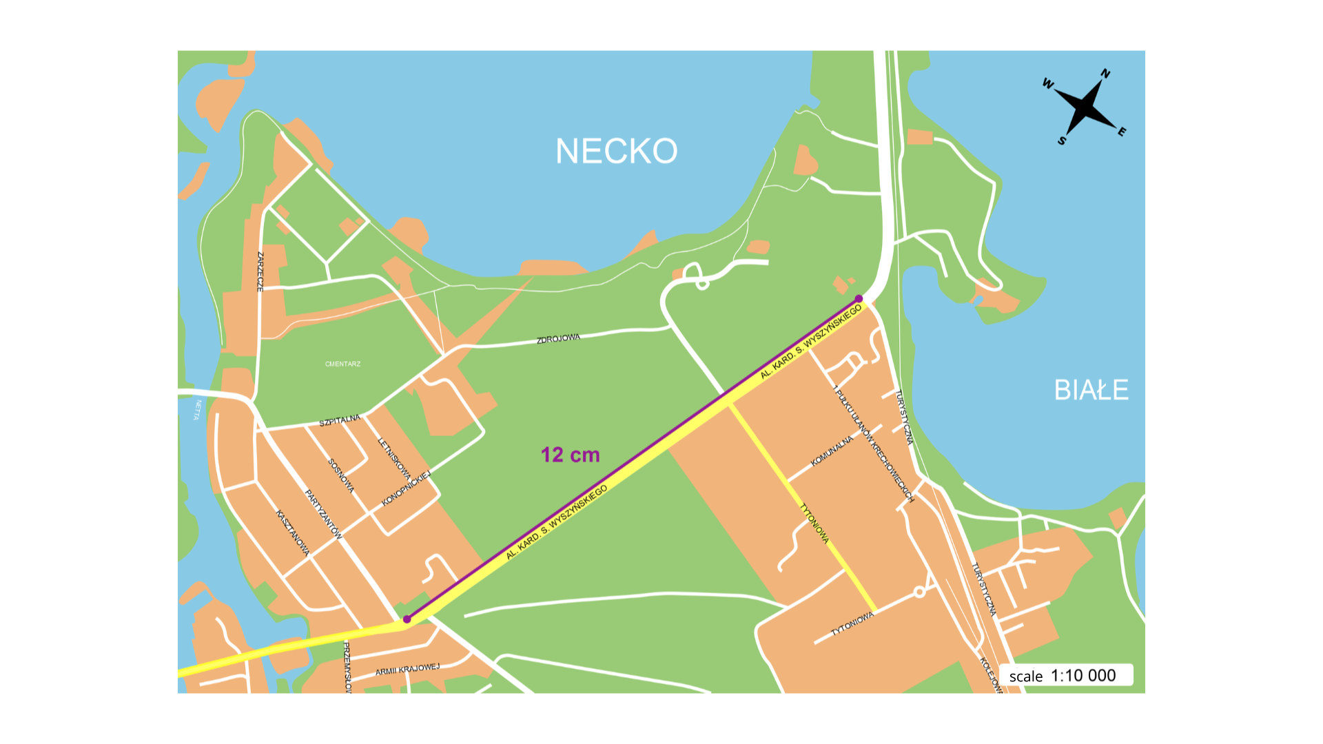
Depending on the information in the drawing calculate the real distancereal distance from the crossing of Kardynała Stefana Wyszyńskiego Avenue and Partyzantów Street to the crossing of Turystyczna Street. Present the result using centimetres, metres and kilometres.
On the plan with the scale of 1 cm – 150 m the distance from the school to the house is 7 cm. How much is the real distance? Give the result in metres and kilometres.
Open the atlas and look at the mapmap of Europe. Use the linear scale to specify how many kilometres on the ground equal 1 cm on the map.
Choose three European capitals which you would like to visit. Use the ruler in such a way you connect Warsaw and the chosen capital with the line. Then use the compass to measure how many unit segments of the linear scale are within the line between Warsaw and selected capital. Finally multiply the result by the number the scale informs about. Give the result in kilometres.
Open the atlas. Look for the administrative - road map of Poland. Calculate the real distance in a straight line between the following cities:
a) Gdańsk, Bydgoszcz,
b) Bydgoszcz, Łódź,
c) Łódź, Kraków,
d) Kraków, Zakopane.
You can use the calculator. Round the results to the nearest kilometre. After completing the task the groups presents their results. Answer the following question:
How many kilometres does the driver have to drive if he goes from Gdańsk to Zakopane via Bydgoszcz, Łódź and Kraków?
An extra task:
Open the atlas and look at the administrative‑road map of Poland. PlanPlan the journey from Lublin to Poznań via three cities. Calculate the real distancereal distance between these cities firs, then calculate the length of the whole route.
Remember:
There are three basic scales on the maps and on the planes: the ratio, the verbal and the linear (bar) scales.
The ratio scaleratio scale is written as a quotient ( can be in a form of a fraction) e.g. 1 : 2000000 (read as one to two million).
The verbal scaleverbal scale is written by using the numbers and the units of length e.g. 1 cm - 2 km (read as one centimetres on a map is equal two kilometres on the ground).
The linear bar is presented graphically.
To calculate the real distance between two places on the map one should measure the straight line distance between them and multiply the result by the number which is read using the scale of the map.
Exercises
If the scale of the map is 1 : 60 000 then 1 cm on the map is equal on the ground
- 60000 cm
- 600 m
- 0,6 km
- 0,06 km
The scale of the housing estate is 1 : 2000. The segment connecting Adam’s house with the shop has the length of 15,5 cm. Calculate the real distance in a straight way between these two places. Give the result in metres.
Imagine you have a map of the world in front of you. Your task is to calculate the real distance in a straight way between New York and Rome.
Describe step by step the method of calculating the real distance between these two cities.
Indicate which pairs of expressions or words are translated correctly.
- skala liczbowa - ratio scale
- skala mianowana - verbal scale
- skala liniowa - linear scale
- rzeczywista odległość - real distance
- mapa - enlargement
- powiększenie - reduction
- map
- ratio scale
- rzeczywista odległość
- skala liczbowa
- mapa
- linear (bar) scale
- skala liniowa
- verbal scale
- real distance
- skala mianowana
Glossary
skala liczbowa
Nagranie dostępne na portalu epodreczniki.pl
wymowa w języku angielskim: ratio scale
skala mianowana
Nagranie dostępne na portalu epodreczniki.pl
wymowa w języku angielskim: verbal scale
skala liniowa
Nagranie dostępne na portalu epodreczniki.pl
wymowa w języku angielskim: linear (bar) scale
rzeczywista odległość
Nagranie dostępne na portalu epodreczniki.pl
wymowa w języku angielskim: real distance
mapa
Nagranie dostępne na portalu epodreczniki.pl
wymowa w języku angielskim: map
plan
Nagranie dostępne na portalu epodreczniki.pl
wymowa w języku angielskim: plan
powiększenie
Nagranie dostępne na portalu epodreczniki.pl
wymowa w języku angielskim: enlargement
pomniejszenie
Nagranie dostępne na portalu epodreczniki.pl
wymowa w języku angielskim: reduction
rzeczywiste wymiary
Nagranie dostępne na portalu epodreczniki.pl
wymowa w języku angielskim: real dimensions
Keywords
ratio scaleratio scale
verbal scaleverbal scale
linear (bar) scalelinear (bar) scale
real distancereal distance
mapmap